Late Cenozoic Uplift in Colorado?
The traditional view
Epis and Chapin (1975) provided the most widely-cited study in support of Late Cenozoic uplift in the southern Rocky Mountains. Their argument hinges on two key pieces of data: 1) a low-relief, Late Eocene erosion surface extending through the Southern Rockies, and 2) the well-known Florissant fossil flora. The gist of their argument is this: The Late Eocene erosion surface indicates that most of south-central Colorado was a relatively dull, continuous landform reaching from the Great Plains to the Sawatch Range; when combined with the Florissant fossils, which seem to be typical of a relatively warm, wet climate, the data suggest that much of Colorado was flat and low-lying (less than 1 km above sea level) prior to the Oligocene. As the same region is highly mountainous and has valley elevations of more than 2 km, uplift has occurred. The inferred timing of the uplift in the Late Cenozoic is derived from sedimentological evidence and correlation to other study areas in the western U.S., such as the Colorado Plateau and the Basin and Range (eg., Christiansen and Yeats, 1992).
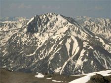
Shaded relief map of the southern Rocky Mountains. Pikes Peak is the prominent high point (purple) in the lower right. A significant portion of the Late Eocene erosion surface is the blue area in the center of the image (Gregory and Chase, 1994).
Some problematic assumptions
The story is relatively simple, but it is worthwhile to take a closer look at the assumptions built into the arguments of Epis and Chapin (1975) and other researchers. There is good evidence for large-scale erosion of the Rocky Mountains in the last 10 m.y. (Christiansen and Yeats, 1992), and it is reasonable to assume that erosion would not occur without some form of high topography. The assumption made by Epis and Chapin (1975) and subsequent studies (reviewed in Christiansen and Yeats, 1992) is that erosion was an immediate consequence of uplift. That is, if the data show erosion beginning between 5-10 Ma, then the timing of uplift, too, can be constrained to 5-10 Ma. This is the source of the interpretation of rapid, recent uplift in the Rocky Mountains. However, it is conceivable that uplift could occur without immediate large-scale incision, and several million years later something else–a change in climate, for example–could cause a dramatic increase in erosion. Erosion, unfortunately, is not well-understood even in the modern day, and so separating tectonically- and climatically-forced erosion is very difficult.
Elevation versus relief?
As a applied to the Late Eocene erosion surface studied by Epis and Chapin (1975), the geomorphological interpretations raise some interesting questions. There is an old idea in geomorphology that a low-relief surface in the geologic record is evidence of a low-elevation "peneplain," representing a mature landscape that erosion has been smoothing for some time. While the peneplain idea itself has been dismissed for the Late Eocene surface in Colorado, there still persists the assumption that a low-relief surface is most likely a low-elevation surface. Two prominent counterexamples exist in the modern world: the Tibetan Plateau and the Altiplano, both of which are regions of low relief and very high elevation in areas of significant tectonic activity. The form of Tibet and the Altiplano is due to crustal properties that do not seem to apply to the Colorado Rockies, but another possibility is that the climate of the late Eocene was such that favored the formation of a low-relief surface even at high altitudes (Gregory and Chase, 1994).
What else can be done?
Thus, geomorphology does not provide the answers, and some other method is needed to reveal just how high the southern Rockies were in the Late Eocene. Methods for determining paleoelevations are few and, almost without exception, quite indirect. Oxygen isotopes (Dettman and Lohman, 2000) and basalt vesicularity (Sahagian and Maus, 1994) have been suggested as possible paleoaltitude indicators, but most studies use paleobotany as a climatic indicator, and then infer elevation from the climate results. The paleobotanical methods for determining both climate and elevation are discussed with specific reference to how the diverse methods have been used to interpret and reinterpret the fossil flora of the southern Rocky Mountains.