Geologic Setting
The majority of the surface volcanic rocks in Baja California were formed during Paleogene and Neogene time. They are largely volcanic rocks related to the subduction of the Farallon Plate underneath the North American Plate, or by mechanisms related to the shutdown of subduction along the same boundary. In order to better understand why Baja California and the Gulf of California are situated as they are today, we will take a brief look at the evolution of western margin of the United States and northern Mexico.
To understand why the western margin looks as it does, we must look to past configurations of tectonic plates along the western margin and in the Pacific Ocean. Since the plates have moved relative to eaxh other through time, we seek a method for reconstructing them to their locations in the past. Two main methods exist for reconstructing the configuration of tectonic plates in the past. The two methods are global plate circuit reconstructions [Stock and Molnar, 1988] and fixed hot-spot assumption [Engebretson et al., 1985]. The former proves to be more reliable, as research has indicated that hot spots are not completely fixed.
Evolution of the Western Margin of North America
The plates with dominant control of the evolution of the western margin include the Pacific, Farallon (and its remnants), and North American plates. A configuration through time of these plates is depicted in Figure 1. Though most the boundary between the Farallon and North American plates is missing, because of subduction of the Farallon plate underneath the North American plate, the past interaction of these two plates is key to understanding the tectonics of the western margin of North America, and thus for the Gulf of California.
Models [Atwater, 1970] suggest that the Farallon plate was moving north east relative to a stable North American plate, subducting underneath North America. The implications of this subduction are widespread for western North America, but most are beyond the scope of this site. The orientation of the Farallon plate was such that the spreading ridge between the Farallon and the Pacific Plates first came into contact with the North American plate by ~30 Ma and had subsequently been split into a northern plate and southern plate [Lonsdale, 1991; Atwater, 1970]. The southern plate was again split into a northern plate and southern plate [Lonsdale 1991; Lonsdale and Klitgord, 1978]. The northern plate, a descendent of the Farallon plate, called the Cocos plate, is of main interest to our investigation into the evolution of the western margin of North America.
The Cocos plate continued the same motion relative to North America, and as it subducted underneath the North American continent, small microplates began to break off. The break off of these microplates was caused by the intersection of ocean spreading ridges between the Pacific plate and the Eastern cocos plate and the subduction trench to the west. As the microplates separated from the down-going Cocos plate, they were captured by the Pacific plate and eventually took on the same motion of the Pacific plate. The method for interpretting their capture is explained in the methodology portion of this site. The northeast motion of the Pacific plate relative to the North American plate is known to have been the same throughout Paleogene and Neogene time [Atwater, 1998]. The formation of microplates can be deduced from magnetic anomalies and fossil spreading centers of these unsubducted microplates that now sit on the Pacific plate. By many, microplate interactions with the North American plate have been attributed as a control for the opening of the Gulf of California.
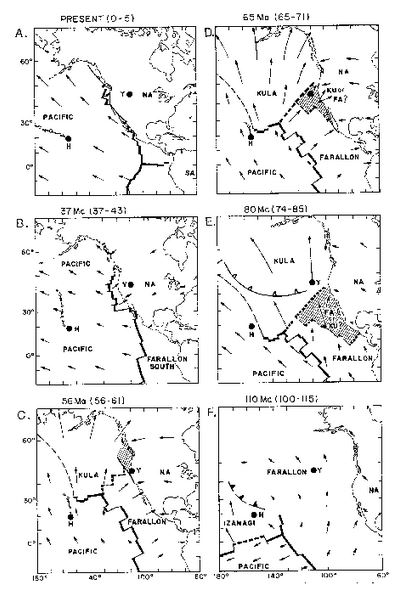
Figure 1. Simplified diagram of the interactions of the North American, Pacific, and Farallon plates through time. Bottom right marks the oldest. After Atwater (1989).
Microplate Capture
Microplates are important because they provide timing of the initiation of initiation of the formation of the North American-Pacific plate boundary for parts of the western margin. After these microplates are stranded from the subducting Cocos plate, they are subsequently transferred to the Pacific plate, and they have the same motion relative to the North American plate as the Pacific plate. It is widely accepted that the Cocos plate broke off small microplates off of the coast of Baja California, and that remnants of these plates are still present off the coast due to the transfer of their movement to the Pacific plate[Michaud et al., 2007]. The two microplates are the Guadalupe and Magdalena.
During Chron 5B (~15 Ma), the north end of the Pacific-Cocos spreading center, south of the Shirley transform fault (figure 2), began to enter the trench. When the Pacific plate came in to strike-slip contact with North America some 400 km south of the Pacific North America-Guadalupe triple junction, a linking shear zone developed [Lonsdale 1991]. This shear zone was ancestral to the modern day San Benito fault zone [Lonsdale 1991].
The timing of the capture of the Magdalena plate is slightly more confusing, as locations of the its fracture zones and fossil spreading centers are not as well constrained [Michaud et al., 2007]. Collision with of the spreading ridge with the continent is believed to have occurred around chron 5D (~12 Ma) [Lonsdale 1991]. Isolation of the Magdalena plate occurred along a fracture zone with ~70 km of right offset which had originated about 750 km south of the Shirley fracture zone (figure 3). The formation of the Magdalena plate initiated the formation of another strike-slip fault, the Toscos-Abrejos fault zone (figure 4) [Lonsdale 1991, Spencer and Normark 1979].
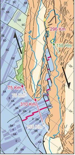
Figure 2. Left is the overall magnetic anomaly profile interpreation for the Gulf of of California and Baja California region. The youngest anomaly evident on the Guadalupe plate is ~ 15 Ma (north and green). The oldest anomaly within the Gulf of Califnornia is ~3.6 Ma. After Flethcher et al. (2007).
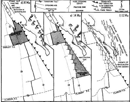
Figure 3. The Shirley fracture zone sites on the southern margin of the Guadalupe plate. Highlights the evolution of both the Guadalupe plate and Magdalena plate from 16-12 Ma. After Lonsdale (1991).
Capture by the Pacific Plate
Based on implementation the technique described on this site, it is evident that both the Magdalena and Guadalupe microplates were captured by the Pacific plate, and thereafter assumed the motion of the Pacifc plate relative to North America. The question of how this may have happened is explored in this section.
There have been many models proposed to explain the transfer of the Guadalupe and Magdalena microplates to the Pacific plate. One proposed mechanism is that some type of a slab-free zone or “asthenospheric window” developed beneath North America following its contact with the Pacific plate [Bohannon and Parsons 1995]. There are two main variants on the slab-free-zone theme. In one, the gap in the slab enlarges with time as the plate contact lengthens, the subducted lithosphere warms, and the slab sinks away [Bohannon and Parsons, 1995; Serveringhaus and Atwater, 1990]. In the other, the size of the slab-gap is limited by the conductive cooling and the formation of new lithospheric mantle material, but a northward migrating active zone persists inland and slightly south of the Mendocino triple junction [Bohannon and Parsons 1995; Furlong et al., 1989].
Another model proposed by Bohannon and Parsons (1995) is dubbed the “stall and deform” plate capture model. Essentially, the forces acting to subduct the slab are overcome by those resisting its subduction, largely because of the termination of spreading at the ridge. Thermal softening within the slab due to its young age, as well as differing strengths along its profile, act to break the upper part slab off from the lower part (figure 5). The upper part of the slab continues to move with Pacific motion relative to North America. Because the part of the slab still sits below North America, movement of the slab causes basal shear forces along the North American plate. It is thought that the surface expression of these forces is an ancestral San Benito fault zone, and the Tosco-Abrejos fault zone.
These models are not the only models to have been proposed for plate capture, and it is quite possible that the models above may not be the sole reason for microplate capture. It may be that there are multiple mechanisms acting to cause the capture of microplates.
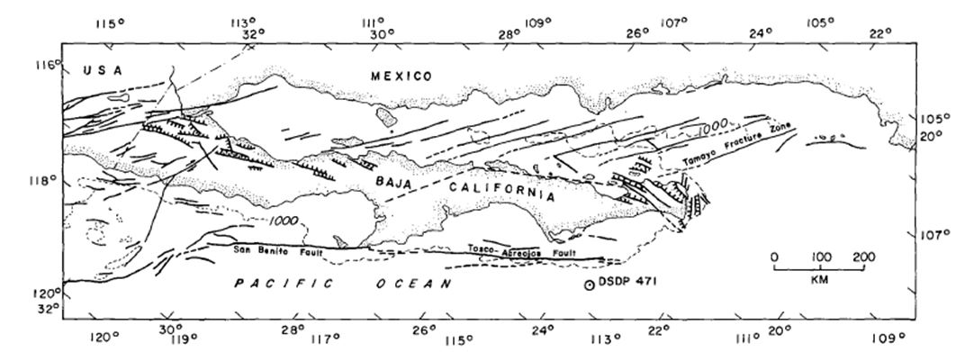
Figure 4. The Tosco-Abrejos fault sits off the western coast of the Baja California peninsula. Based on studies of the Magdalena fan, up to 150 km have occurred since its formation. After Spenver and Normark (1979).
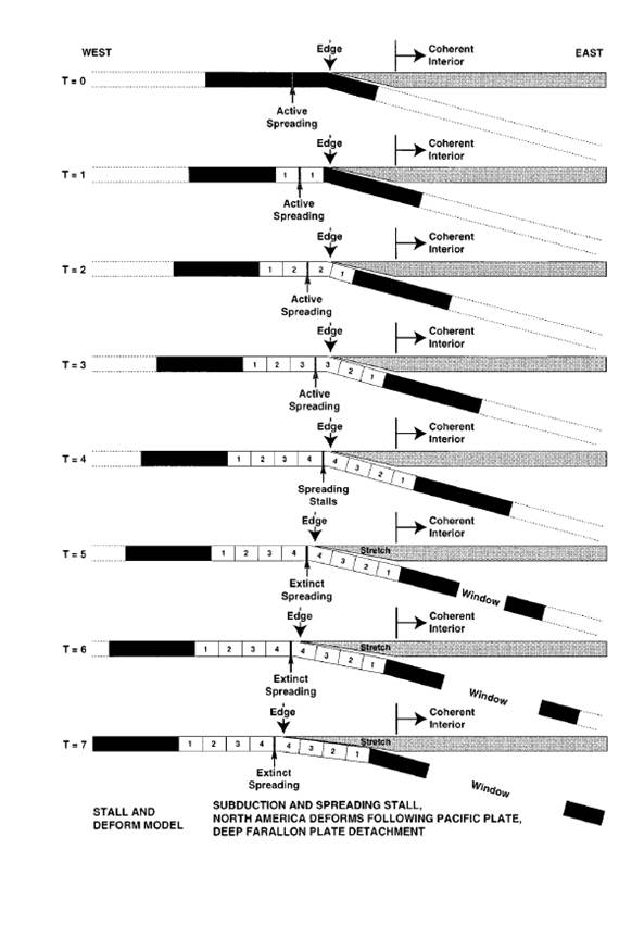
Figure 5. Stall and Deform model of plate capture. The model provides a way for the capture of microplates along the western margin of North American by the Pacific plate. One of many proposed models that attempts to explain the capture. After Bohannon and Parsons (1995).
Transfer of Motion into the Gulf of California
Because of the timing of the initiation of the development of spreading centers within the Gulf of California, as well as completed plate reconstructions, it is widely accepted that the movement between the Pacific and North American plates must have been accommodated elsewhere. Plate reconstructions have proposed that there is somewhere on the order of 250-300 km of movement between the two plates that cannot be accounted for in the Gulf of Mexico [Oskin et al., 2001]. An obvious solution would be that the movement was taken up along features outboard of Baja California. Studies on movement of the Tosco-Abrejos fault zone (figure 4) off the coast of Baja California, namely the Magdalena Fan, have shown that only ~150 km of this movement can be attributed to the fault zone, which is evidenced from the provenance of detrital zircons on the fan itself [Fletcher et al., 2007]. So where else might there have been shear that was accommodating movement between the two plates? Gans et al. (1997) conducted field work that shows that they can attribute up to 40 km of shear on individual faults along the coast of Sonora, Mexico. This still leaves a considerable amount of missing movement between the two plates, but it gives us an idea of how the movement was partitioned before the opening of the Gulf of California.
Based on the oldest magnetic anomaly at the mouth of the Gulf of California (figure 2), it is evident that the Gulf must have started to spread by ~3.6 Ma [Demets, 1995], but spreading of the Gulf of California over the past ~3.6 Ma alone cannot account for the total amount of movement that has occurred within the Gulf. This indicates its opening must have started sometime between the capture of the Magdalena plate (~12 Ma) and the initiation of spreading (3.6 Ma). To further evaluate the timing of opening, Oskin et al. (2001) used volcanic tuffs that were bisected by the opening of the Gulf of California. They used two tuffs, ages 12.3 Ma and 6.0 Ma, to assess the movement. When they compared the locations of the two tuffs they found that there had been little or no movement in the time period between the emplacement of the tuffs, and that all the movement that had displaced the tuffs must have occurred since 6 Ma. This constraint provides an upper bound for the initiation of the opening of the Gulf of California. Therefore, based on evidence from magnetic anomalies and structural offsets the initiation of the opening of the Gulf of California must have happened sometime between 3.6-6.0 Ma based on magnetic anomaly and structural interpretations.