
![]()
Tandem satellites monitor glacial melting
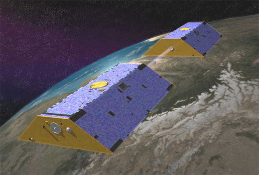
Dorsi works with GRACE, or the Gravity Recovery and Climate Experiment, a satellite system capable of sensing changes in water storage both above and below ground. Using GRACE data, he found that Asia’s high mountain glaciers are shedding more than 30 billion tons of water every year, enough to raise global sea levels 0.85 millimeters in a decade.
But quantifying the exact contribution of Asian glacial melt to sea level rise is tricky, he said. “Landlocked basins in South and Central Asia may store large amounts of runoff currently draining from the high mountains, and this could prevent runoff from contributing to sea level change,” said Dorsi.
How can GRACE detect changes in water storage? Orbiting the planet in tandem, the twin satellites sense tiny variations in Earth’s gravity field. Aquifers and ice fields add mass to the planet, creating pockets of stronger gravitational pull. Regions with stronger gravity fields tug on the satellite pair, increasing the speed of the first, and then the other, altering the normal distance between them. Researchers use these changes in the distance between the satellites to determine how much water has been lost from one region and added to another. ![]()
Sciences at the University of Colorado at Boulder.
“Satellites offer researchers a way to capture information from remote areas around the globe,” said Dorsi. They are a particularly important tool for studying regions where ground measurements are sparse and complex terrain and limited infrastructure complicate field work efforts, he said.
In South and Central Asia, more than half a billion people rely on glacier-fed streams for drinking water, irrigation, and power generation. A changing climate could put much of the region’s water supply at risk.
That’s why researchers, including CIRES graduate student Sam Dorsi, are now keeping an eye on Asia’s glaciers from space. Dorsi is working towards a doctoral degree in Atmospheric and Oceanic