Shade 32 and related codes: Overview
What is "shaded topography"?
Many pretty physiographic maps combine local relief in the form of shading (changes in the lightness of an image) with elevation in the form of color
(combined hue and saturation, mostly). In certain circumstances this
is the best way to convey a feel for the Earth's surface. While usually
this is applied to topography, there is no reason it cannot be applied
to other functions, and indeed maps where the colored variable is seismic
acceleration or geology or gravity anomalies can be quite interesting.
Here's a "traditional" shaded topo map for the southern Sierra Nevada:
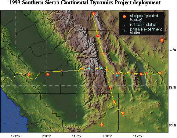
Location map of 1993 Southern Sierra Continental Dynamics Project; Sierra is near center (between 118 and 119 degrees west); Owens lakebed is just east of crossing of refraction lines. Death Valley is deep (darkest green) valley in the eastern part of the map. (Clicking on map will get you bigger, full color JPEG image).
Over the past couple of years I have wanted to be able to make shaded
topographic and similar maps on my Mac without resorting to a GIS (many of
which cannot make very good looking images). The first attempts, and most
reliable codes, used Spyglass Transform (although similar codes like
NCSA DataScope might work as well), which only makes 8-bit images.
This will work on a Mac or Sun (and probably PC).
The 8-bit limitation is frustrating as the approach used results in banding of topography
and/or shading. I recently have managed to get a 32-bit (well, 24-bit)
color pixmap made using a code I specially wrote for the Mac called Shade 32.
The image above uses the output from that code (dithered to 8-bit for GIF format).
Disclaimers and conditions of use
Much of this software is fairly primative. I cannot be responsible for any
bugs or other problems caused by errors in these codes.
Although distributed freely, I retain copyright to this software. The software
may be freely shared but cannot be redistributed for a price (other than
the cost of copying) without my express written consent.
If you encounter bugs, please let me know so I can squash them or at
least share the troubles with others. Bug reports will be added to this
page if and when I become aware of them.
Be nice--I am getting no financial compensation for this and no real
boost to my career. If you use these codes to produce an image used
in publication, I would appreciate acknowlegement and a copy of the
publication, if possible. That's all I get out of sharing this stuff.
So what's here?
There are three separate pieces to this puzzle, any one of which might
be of use:
 TopoToAlbersFull
- Extracts topography from either Topo30 or ETopo5 databases (preferably
on National Geophysical Data Center's Global Relief Data CD-ROM)
and projects the data into an Albers equal-area projection. Output is a packed 2-byte (short) integer binary file. Not elegant--a tty-style interface.
 Shading with Transform
- Codes to take packed 2-byte integer files and shade them, to combine 2 files
to make a "shaded topography" file to be used with Transform, to
convert output HDF files into packed integer files. Generally unelegant
interfaces on these codes--old style tty interfaces.
- See an illustrated summary of the processing to make shaded topography
type files solely within Transform,
with several nice images and links to example HDF files. This is
pretty much identical to how these (external) codes work.
- See the brief description of how these codes work
- Download Binhex version of Transform-related mapping codes archive (1,411,330 bytes, 12 May 1995)
- Download MacBinary version of Transform-related mapping codes archive (1,038,720 bytes, 12 May 1995)
 Shading with Shade 32
- Shade 32 is a "normal" Mac application written in FutureBasic (unlike
the fortran codes above) that will combine a binary integer files with either
another packed integer file and a palette OR a PICT image to make a shaded
topographic-style PICT file. Will save the image as a 32-bit PICT.
***This program
is basically an ALPHA-type product. System crashes or even corruption
of the system file might be possible. Please read the documentation***
Craig H. Jones
CIRES, Campus Box 216
University of Colorado at Boulder
Boulder, Colorado 80503
cjones@mantle.colorado.edu
Return to C.H. Jones home page
Craig Jones, cjones@mantle.colorado.edu
