Maria
Fold and Thrust Belt
Geologic
History
Geologic
History
- 40Ar/39Ar step-heating
- References
Introduction:
What is the Maria Fold and
Thrust Belt, and why is it important?
The Maria Fold and Thrust Belt (MFTB) is a thick-skinned fold and
thrust belt of Mesozoic-age crustal shortening that stretches West-East
from southeastern California to west-central Arizona (Spencer and
Reynolds, 1990). It is characterized by generally south-vergent folds
and top-to-the-south thrusts that place Proterozoic basement rocks over
highly-deformed Paleozoic and Mesozoic sedimentary and volcanic strata
(Spencer and Reynolds, 1990). This makes it differ from other parts of
the Andean-style Cordilleran Orogen, in which deformation generally
occurred via East-West shortening in North-South-trending belts.
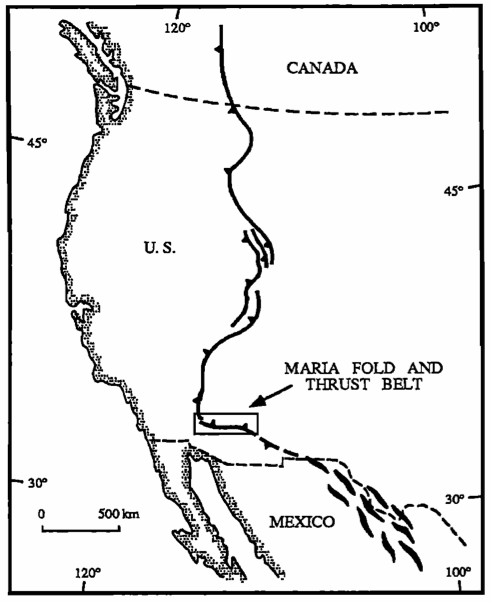
|
Left: The
Maria Fold and Thrust Belt is oriented orthogonally to the structures
of the rest of the Sevier Belt. From Knapp and Heizler (1990). Right: The
Maria fold and Thrust Belt is located in Southeastern California and
western Arizona, as indicated by the box with the lines running
diagonally through it. Figure from Reynolds et al. (1989).
|
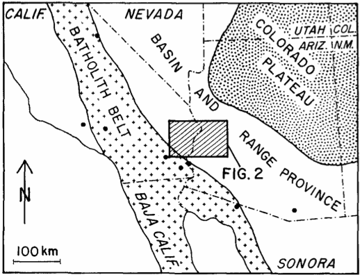
Present-day Geography
Rocks deformed in
the Maria Fold and Thrust Belt can be found in around a dozen
present-day ranges
across the Mojave and Sonoran deserts of western Arizona and
southeastern California. According to Spencer and Reynolds, 1990
(Figure 1). These include the:
|
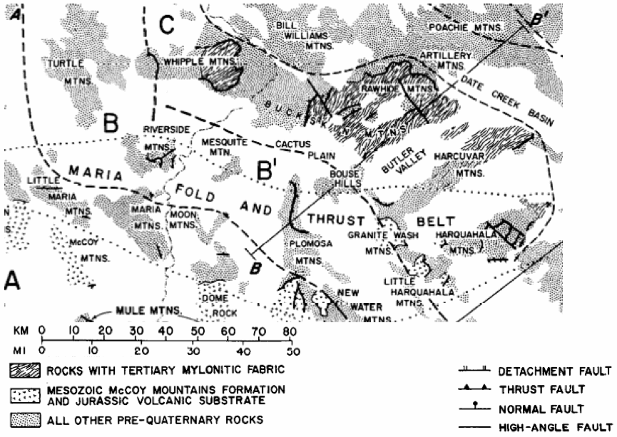
Generalized geologic map
of the Maria Fold and Thrust Belt, adapted from Spencer and Reynolds
(1990). Click for a larger version.
|
- Bearskin Mountains
- Coxcomb Mountains
- Big Maria Mountains
- Dome Rock Mountains
- Granite Wash Mountains
- Harquahala Mountains
- Little Harquahala Mountains
- Little Maria Mountains
- Mesquite Mountain
- Moon Mountains
- New Water Mountains
- Palen Mountains
- Plomosa Mountains
- Riverside Mountains
In addition to these, some additional ranges are sometimes included in the Maria Fold and Thrust Belt.
- Buckskin Mountains
- McCoy Mountains
- Mule Mountains
- Rawhide Mountains
The
south-dipping Mule Mountains thrust, oriented opposite many of the
north-dipping MFTB thrusts, is sometimes considered its own entity, as
are the Buckskin and Rawhide Mountains, which saw a large amount of
Tertiary extensional deformation. The McCoy Mountains are the type
locality for the McCoy Mountains Formation, which is associated with
MFTB deformation, but is often not considered to be part of the MFTB
proper.
Geologic
Setting
The region of the present-day Maria Fold and Thrust Belt was first
formed in Proterozoic time. After its formation, its story was one of a
quiet
portion of the stable North American continental lithosphere, steadily
accumulating sediments. This lasted until a Late Triassic through Early
Triassic uplift. Later in the Mesozoic,
the Cordilleran orogeny formed the complex patterns of deformation
associated with the MFTB.
Proterozoic:
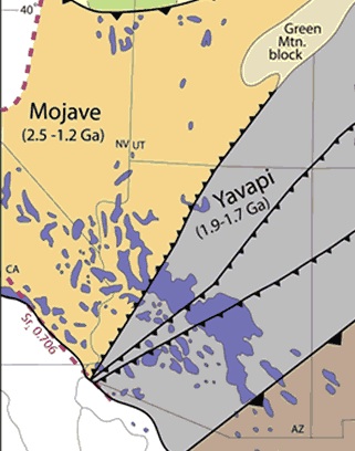 |
The Mojave and Yavapai Provinces are the Proterozoic basement rocks of the Maria Fold and Thrust Belt. (Modified from USGS.)
|
The
Maria Fold and Thrust Belt lies both in the Mojave Provence and in the
transition zone between the Mojave Provence and the Yavapai Provence
(Duebendorfer et al., 2006, Figure 1: after Wooden and DeWitt, 1991).
The Mojave and Yavapai Provinces are tectonostratigraphic terranes:
that is, they contain consistent and related suites of rocks. They,
along with the Mazatzal Province of southeastern Arizona and New
Mexico, constitute the major tectonostratigraphic terranes of the
American Southwest.
The Mojave Provence is the oldest of these three tectonostratigraphic
terranes. It is poorly-known because (1) it is discontinuously exposed
in the cores of mountain ranges, (2) its rocks are often out of place
because they lie in the upper plates of Mesozoic thrust faults with
tens to hundreds of kilometers of displacement, and (3) many of these
rocks are highly deformed and metamorphosed, resulting in the
destruction of their original lithologic and geometric relationships
(Baldridge, 2004).
In spite of these difficulties, geologists have deciphered a history
for the southern part of the Mojave Provence, which is where the Maria
Fold and Thrust Belt lies. Samarium-neodymium work shows that the
earliest portions of the Mojave Provence were extracted from the mantle
around 2.6 Ga. These dates, now found in magmatic rocks, is likely from
sedimentary detritus that was subducted and re-erupted in a volcanic
arc (Baldridge, 2004). The oldest zircon ages here are 2.3. Ga. These
supracrustal rocks were intruded by granodioritic to granitic magmas
between 1.76 and 1.64 Ga. During this period of magmatism,
between 1.74 and 1.72 Ga, the Mojave Provence accreted to the Yavapai
Provence. Between 1.71 and 1.70 Ga, the rocks of the Mojave province
were transformed into complex assemblages of gneiss and migmatite
during high-pressure low-temperature metamorphism associated with the
Ivanpah Orogeny (Baldridge, 2004). It was during this time that the
transition zone formed between the Mojave and Yavapai
tectonostratigraphic terranes.
Beginning about 1.6 Ga, the Mojave Provence and the rest of Laurentia
entered a period of tectonic quiescence that lasted approximately 100
million years. Although activity later resumed in the Yavapai and
Mazatzal Provinces to the South and East, the Mojave Provence did not
see major deformation for the remainder of the Proterozoic. (Baldridge,
2004)
Paleozoic:
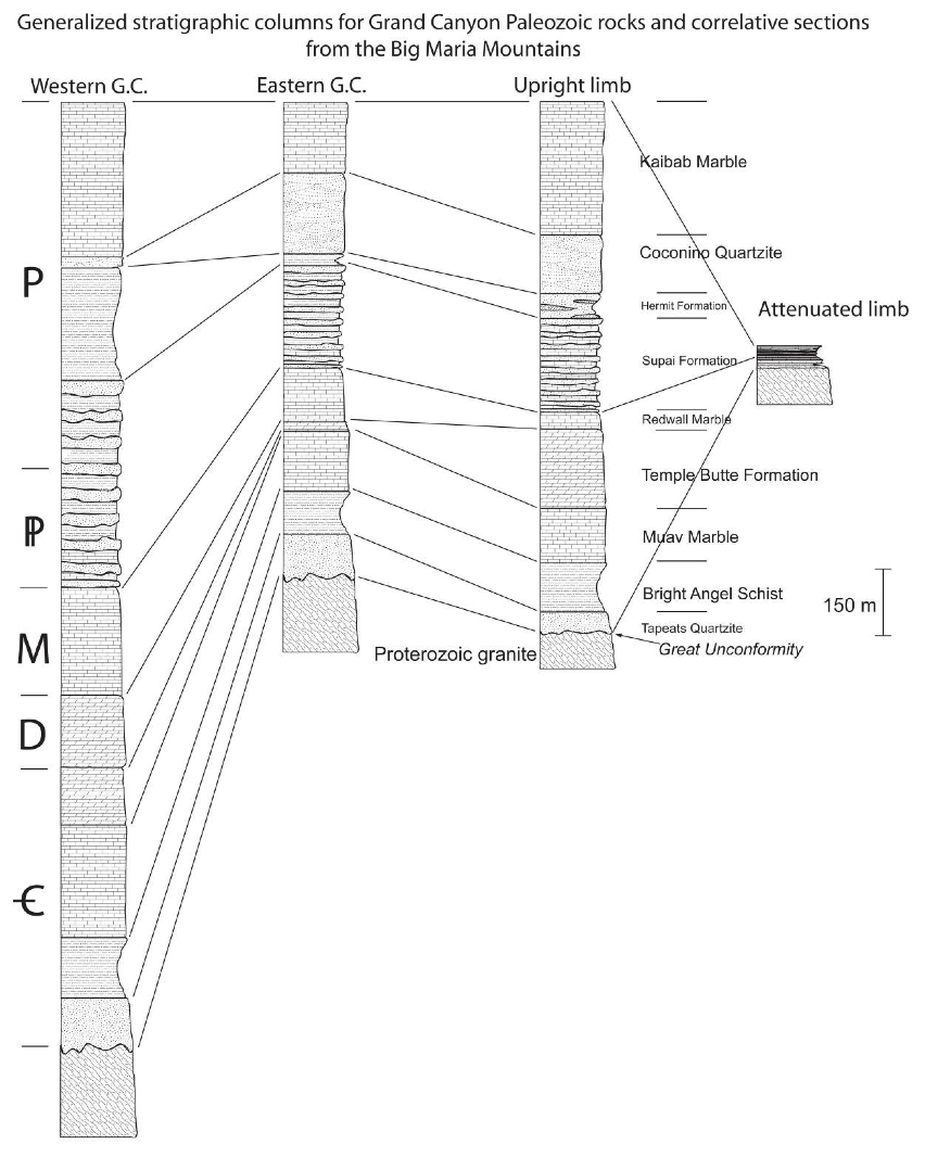 |
Left two columns are from the
Grand Canyon, and right two columns are from the Big Maria Mountains.
Thicknesses in the Big Maria Mountains are modern, not original
depositional. Figure compiled and constructed by Salem (2009) based on
data collected by Beus and Morales (2003) and Salem (2005).
Stratigraphic correlations were described by Hamilton (1982).
|
At the dawn of the Paleozoic, the region that would become the Maria
Fold and Thrust Belt was a quiescent shallow sea underlain by the North
American craton. The Paleozoic stratigraphy of the Maria Fold and
Thrust Belt is the same as that which is found in the Grand Canyon, as
they were in the same region and depositional environment: In fact,
these rocks are found as far from the Grand Canyon as southwesternmost
Arizona, USA, and Sonora, Mexico. At the bottom is the Upper Cambrian
Tapeats Quartzite. On top of this, from bottom to top, are the Bright
Angel Schist, the Muav Marble, undifferentiated dolostones, the Temple
Butte Formation, the Redwall Marble (which may include a broader age
range of metamorphosed limestones than does the Redwall in the Grand
Canyon proper), and the Pennsylvanian-Permian Supai Group. Above the
Supai Group are the Hermit Schist, Coconino Quartzite, Toroweap Marble,
and Kaibab Marble; the Toroweap and Kaibab are typically
undifferentiable and simply are called the "Kaibab" in the MFTB.
(Hamilton, 1987; Salem, 2009.)
The continental margin of Late Paleozoic (Mississippian to Permian)
North America tells a more active story. From the start of the
Paleozoic until the Mississippian, the continental margin of the
Western US was a passive margin that underwent shallow marine
sedimentation. In early Mississippian time, this passive margin became
an active margin. The Antler (Early Mississippian), Havallah, and
Sonoma (Late Permian to Early Triassic) terranes accreted in that order
to the western margin of North America, and overthrust one another in
sequence (Burchfiel and Davis, 1972, 1975; Dickinson et al., 1983).
This added a large amount of material to the western margin of North
America.
At some point between and including the Pennsylvanian and the Triassic,
the southwestern margin of North America was truncated. This truncation
removed terranes that had accreted prior to it, and prevented terranes
from accreting after its initiation. Burchfiel and Davis (1975)
suggested that this was due to either rifting or transform faulting
around the Permo-Triassic boundary to early Triassic time, following the
Sonoma Orogeny. This truncation event would have removed the accreted
terranes and exposed the North American craton on the continental
margin. Stone and Stevens (1988), Stevens et al. (1997), and Stevens et
al. (2005) argue that this truncation event was caused by the
left-lateral Mojave-Sonoran Megashear, which translated the
southwestern edge of North America southeastward to the
Caborca-Hermosillo region of Mexico. They also place the event much
earlier, during Pennsylvanian time. Though neither Stone and Stevens
(1988) nor Stevens et al. (1997) state how this would relate to the
Permo-Triassic Sonoma Orogeny, the change of this margin from a
convergent boundary to a transform one presumably would have prevented
the Sonoma Orogeny from reaching the Southwest.
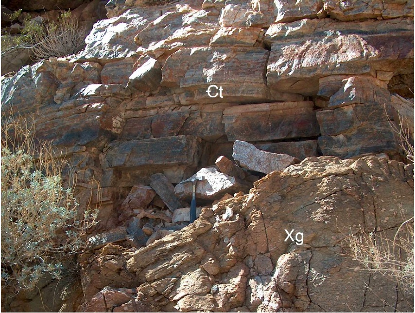 |
The Great Unconformity in the
Big Maria Mountains. Cambrian Tapeats Quartzite (Єt) lies unconformably
above Proterozoic Granite (Xg). Photo by Anthony Salem (Salem, 2009).
|
Mesozoic:
Lying above the well-known Paleozoic section is the Mesozoic sequence
of the Maria Fold and Thrust Belt. Lying above this is the Triassic
Buckskin Formation, which correlates with the Moenkopi Formation
further East, and the Triassic-Jurassic Vampire Formation, correlative
to the Chinle. The Jurassic Aztec Quartzite lies atop the Vampire
Formation; it has been correlated with and named after the aeolian
Jurassic Aztec Sandstone of southern Nevada, which in turn is
correlative with the Navajo Sandstone of the Colorado Plateau. However,
it is more likely correlative with the Page and Carmel Sandstones.
Above these sedimentary strata lie a sequence of Jurassic volcanic
rocks of the Dome Rock Group; these volcanics are associated with
widespread Jurassic arc magmatism that extended from British Columbia,
Canada, to northern Sonora, Mexico. Jurassic plutonism also occurred,
but these plutons are unlikely to be correlated with the Jurassic
volcanism, and some may be Cretaceous in age. Later in time, the
Jurassic-Cretaceous McCoy Mountains Formation was deposited as >7 km
thick siliciclastic wedge to the south of the MFTB. (Salem, 2009)
The Triassic Buckskin Formation is the stratigraphically lowest
Mesozoic unit in the Maria Fold and Thrust Belt (Salem, 2009). It
comprises anhydrite-bearing schists and calcareous sandstones, and is
named for the Buckskin Mountains of western Arizona (Reynolds, 1987).
Its maximum thickness is approximately 600 meters at Palen Pass (Salem,
2009). Its basal unit is a green gypsiferous schist and sandstone, and
its upper unit is a green to orange calcareous sandstone. Reynolds et
al. (1989) correlated it with the Triassic Moenkopi Formation of the
Colorado Plateau and elsewhere in the western United States, which
contains similar (though unmetamorphosed) lithology and unconformably
overlies the Permian Kaibab Limestone (Salem, 2009). Pelka (1973) and
Stone and Kelly (1989) likewise correlate it with the lower two members
of the Palen Formation.
The Triassic-Jurassic Vampire Formation comprises a lower conglomerate
unit and an upper unit of volcaniclastic sandstones (Reynolds, 1987).
The conglomerate consists of angular to rounded clasts of heterogeneous
composition, which indicates sediment input from a nearby source that
had a diverse lithology (Reynolds, 1989). The gray-green sandstone unit
has volcanically derived clasts. Together, these units constitute the
400 meter thick Vampire Formation (Salem, 2009). It is correlative to
the Chinle Group of the Colorado Plateau, and unconformably overlies
units that range in age from Proterozoic through Triassic. This
unconformity, coupled with the basal conglomerate, is evidence for Late
Triassic-Early Jurassic uplift. This is possibly due to the onset of
active-margin tectonics further west, as the Cordilleran magmatic arc
initiated during Late Triassic time (Reynolds et al., 1989; Salem,
2009; Stewart et al., 1972; Asmerom, 1988). Further evidence of uplift
and volcanism exists in an influx of volcanic ash into the Chinle
Group, Triassic-age volcanic rocks in southeastern Arizona, and
Triassic-age plutonism in southwestern Arizona and southeastern
California (Busby-Spera, 1988; Asmerom et al, 1988; Salem, 2009).
The Jurassic Aztec Quartzite is an erg with a maximum thickness of 300
meters in the Palen mountains. It indicates a return to stable cratonal
conditions. Though it is typically correlated with the massive
Navajo/Aztec Sandstone erg that blanketed much of the western US during
Early Jurassic time, U-Pb dates on interbedded volcanic rocks at Palen
Pass give an age of 174±8 Ma (Middle Jurassic). This indicates that it
is more likely correlative to the Page or Carmel Sandstones of the
Colorado Plateau (Fackler-Adams et. al., 1997; Salem, 2009).
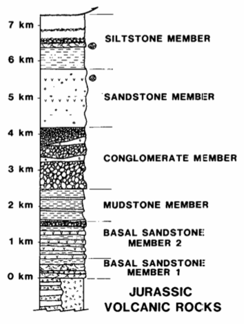 |
Generalized stratigraphic
column of the Late Jurassic–Cretaceous McCoy Mountains Formation and underlying
Jurassic Rhyodacites. From Harding and Coney (1985).
|
Arc magmatism during Jurassic time resulted in the explosive eruption
of
rhyodacitic felsic volcanics (Harding
and Coney, 1985; Barth et al., 2004). These units include the Planet
Volcanics of the Buckskin Mountains (Reynolds et al., 1987) and the
Dome Rock Group of the Palen Mountains and vicinity (Tosdal et al.,
1989), which are correlative with one another. They are 1260 meters
thick in the northern Palen Mountains. They comprise two members: a
lower greenish-gray micaceous schist that
is likely correlative with rhyodacite tuffs and tuffaceous sedimentary
rocks in the Palen Mountains, and a upper unit correlative with
rhyolitic ignimbrite, lava, and a hypabyssal quartz porphyry in the
Palen Mountains
(Salem, 2009). The presence of these
volcanics indicates a resurgence of tectonic and magmatic activity in
the area, and foreshadows Cretaceous deformation in the Maria Fold and
Thrust Belt. Indeed, Tosdal et al. (1989) note that they are part of
the Cordilleran magmatic arc that extends from British Columbia in the
North to Sonora in the South. U-Pb ages for the Dome Rock Group are
174±8 Ma at their base, and are 162±3 Ma and 155±8 Ma nearer to their
top, placing them in Middle to Late Jurassic time (Salem, 2009).
Aerially extensive Jurassic-age plutonism sweeps through southwestern
North America and date to ~160 Ma (Tosdal et al., 1989). Felsic plutons
comprise three major members in the MFTB: a dark green
hornblende-bearing diorite, a light gray granodiorite with
centimeter-scale euhedral lavender-color feldspars, and a leucocratic
granite. In addition to this is a set of fine-grained mafic intrusive
rocks that are presumed to be intruded at the same time (Salem, 2009).
Above the Jurassic
volcanics, the
7.3-km thick Jurassic-Cretaceous McCoy Mountains Formation was
deposited. The
McCoy Mountains Formation is siliciclastic, and consists of six
distinct members. It is often weakly metamorphosed, and its top is
never exposed. This formation is local to the Maria Fold and Thrust
Belt, and therefore is very different from the other Formations in
Utah,
Colorado, Arizona, and elsewhere in the southwestern United States.
It is likewise dissimilar to the exotic terranes to the West, and
is relatively less-well known. Its depocenter is the McCoy Basin, to
the South of the MFTB. (Barth et al.,
2004; Harding and Coney, 1985; Salem, 2009).
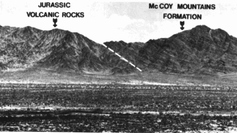 |
Contact between the
Jurassic arc rhyodacites and the Cretaceous (perhaps late Jurassic at
the base) McCoy Mountains Formation. View is to the East, from the
Palen Mountains, so North is to the left. Contact dips ~40º to the
south. From Harding and Coney (1985).
|
Detrital zircon data place the McCoy Mountains
Formation at a maximum depositional age of 116 Ma near the bottom of
the formation, and 84 Ma near its top. It is possible that its basal
sandstone is Jurassic in age, but at least 90% of the Formation was
deposited during the Cretaceous (Barth et al., 2004).
The McCoy Mountains Formation was deposited in the McCoy–Bisbee Basin.
This basin was an extension of the opening of the Gulf of Mexico, and
its formation was aided by thermally-softened lithosphere due to the
arc magmatism occurring in the Southwest at that time (e.g., Salem,
2009). In the Southwest, it is interpreted by Salem (2009) to be a Late
Jurassic–Cretaceous rift system. The Jurassic and earlier Cretaceous
portions of the McCoy Mountains Formation deposited in this extensional
setting.
The later Cretaceous portions of the
McCoy Mountains Formation are interpreted to be deposited in the
foreland basin of the actively-deforming Maria Fold and Thrust Belt to
the north and behind
active magmatic arc of the Cordilleran orogen to the West. This
deposition was also synchronous with East-West-shortening Sevier
tectonism North of the MFTB (Barth et al., 2004).
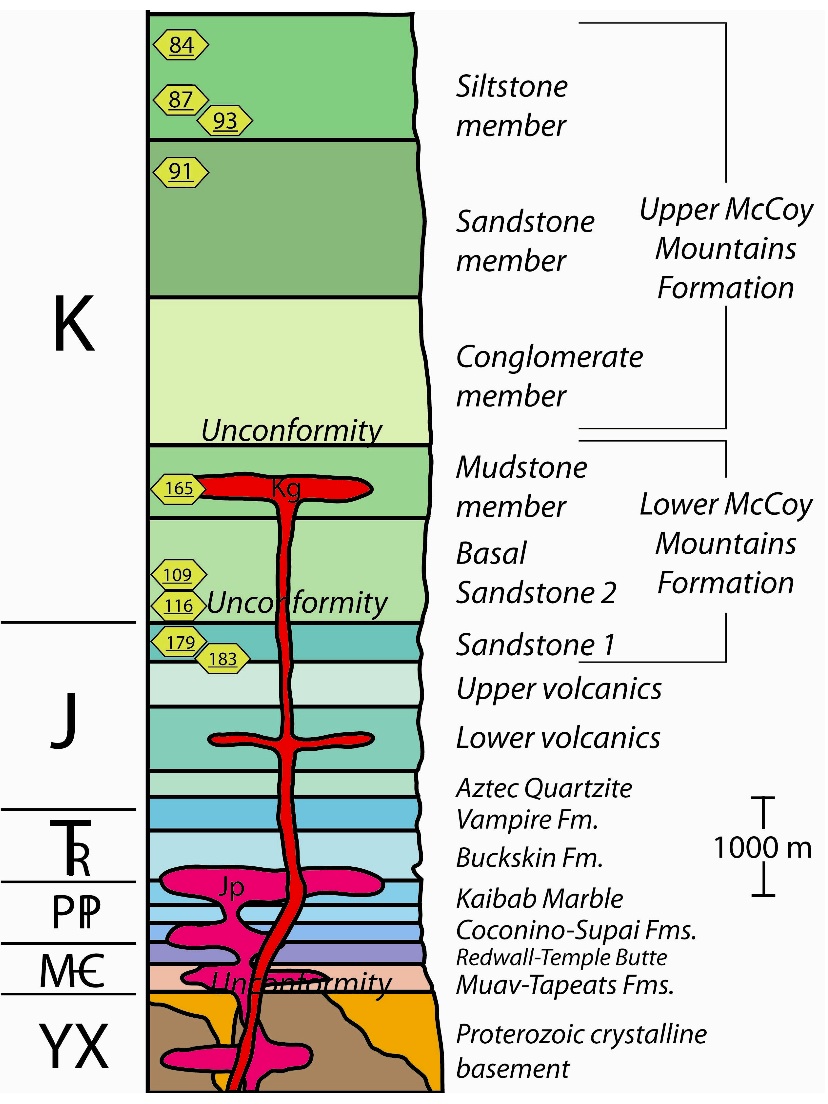 |
Generalized stratigraphic
column of the pre-Tertiary rocks of the Maria Fold and Thrust Belt and
McCoy Basin. Numbers in yellow hexagons are published detrital zircon
ages from Barth et al. (2004). Figure from Salem (2009), Figure 2.4.
|
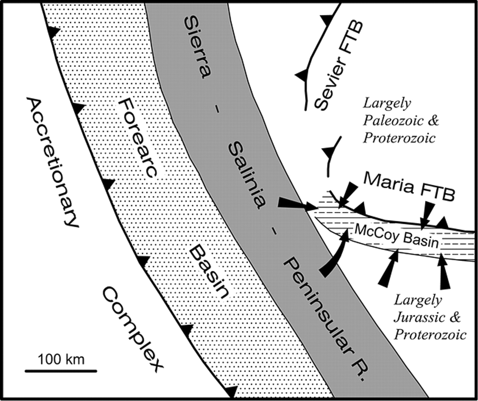
Tectonic Setting
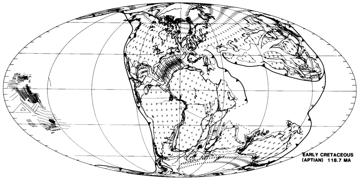 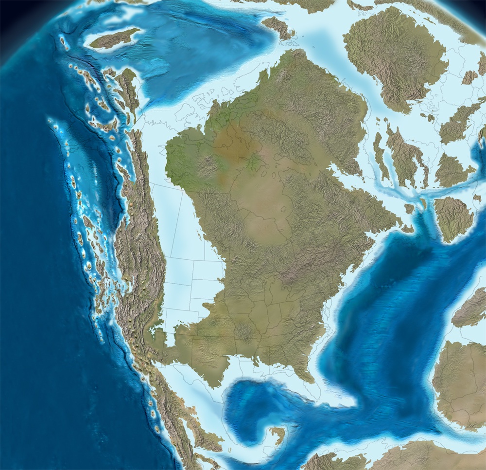 |
Left:
Aptian tectonic reconstruction by Scotese (1991). Note the east-dipping
subduction zone on the western margins of North and South America that
runs nearly from pole to pole. Right: North American paleogeographic
reconstruction by Ron Blakey (NAU Geology) also from Aptian time (115
Ma).
|
During Mesozoic time and extending into the Cenozoic, a broad
east-dipping subduction zone bounded the western margin of the Americas
and extended nearly from pole to pole. (This same subduction zone
existed earlier, but its geometry was different due to the changing
positions of the continents.) Subduction along this margin caused
volcanism, and the accretion of island arcs and exotic terranes via
this tectonic conveyor belt deformed both North and South America.
In Aptian time (Heller et al., 1986), subduction along the west coast
of North America initiated the Andean-style Sevier Orogeny. The Sevier
Belt formed in the foreland of the Sierra Nevada arc, and consists
of large-scale east-vergent thrusts (Heller et al., 1986) and
west-dipping, east-vergent folds. Its hinterland records high-grade
metamorphism and plutonism associated with synconvergent extension; in
this, it is unlike the Andes. (Salem, 2009)
Between approximately 80 and 40 Ma, the Laramide Orogeny deformed much
of western North America (Salem, 2009). Laramide-age deformation
reached as far inland as Colorado, Wyoming, and western South Dakota
(the Black Hills). This is attributed to the shallowing of the angle of
Farallon Plate subduction into a "flat slab". The end of the Sevier and
the onset of the Laramide flat slab subduction likewise changed the
style of convergence around the MFTB.
Evolution
of the Maria Fold and Thrust Belt
 |
Theorized depositional tectonics of the McCoy Mountains Formation. From Barth et al. (2004). Click for larger image.
|
Prior
to deformation, the rocks that constitute the Maria Fold and Thrust
Belt were part of the stable North American craton (Spencer and
Reynolds, 1990; above sections). Between
90 and 80 Ma (middle Late Cretaceous time), deformation in
thick-skinned fold and thrust belts caused regional heating of the
crust (Knapp and Heizler, 1990). These structures strike generally east-west and accommodate north-south-directed shortening.
This deformation is hypothesized to be related to the Sevier Orogeny (Salem, 2009), which
lies
in North-South-trending bands of East-West crustal shortening in a
classic wedge shape (e.g., Dahlen and
Suppe, 1988) that thickens to the west. This orogenic wedge consists of
Paleozoic and Upper Proterozoic continental margin sedimentary rocks
that have been displaced eastward onto the North American continent.
This Sevier Belt shortening parallels the north-south plate boundary of
east-west convergence between the North American and Farallon Plates.
This makes logical sense: east-west compression along a north-south
boundary creates north-south bands of east-west shortening.
However,
MFTB structures trend orthogonally to the rest of the Sevier
Orogeny. They lie east-west and accommodate north-south crustal
shortening. Even considering the bend in the Farallon-North American
plate boundary
around southern California, MFTB structures are still at least 45º away
from the angle of convergence. Salem (2009) and earlier researchers cited therein hypothesize that the McCoy
Mountains Formation was deposited in a roughly east-west-oriented rift
basin as an extension of the opening of the Gulf of Mexico, and that
this rift basin created a pervasive lithospheric weakness that strongly
influenced the orientation of the MFTB.
The MFTB is also unique in that it experienced basement
involved ("thick skinned") deformation
(Burchfiel and Davis, 1975). A likely explanation for this lies in the
truncation of the margin of the American Southwest. Whether due to a
Pennsylvanian Mojave-Sonoran Megashear (Stone and Stevens, 1988;
Stevens et al., 1997; Stevens et al., 2005) or to a Permo-Triassic to
Triassic event (Burchfiel and Davis, 1975, p. 373), the zone of
thickened crust where the Antler, Havallah, and Sonoma terranes
accreted was removed (or not allowed to form, in the case of the Sonoma
Orogeny and Stone-Stevens hypothesis). This hypothesized truncation
likely stretched from Central
California to at least the Trans-Mexico volcanic belt (Burchfiel and
Davis, 1975), and left cratonal rocks exposed at the continental
margin. These
then deformed as the Farallon Plate subducted under western North
America. Because of how thin this cratonal sedimentary cover was,
deformation involved the Precambrian basement and resulted in the
exhumation of multiple
crystalline nappes in the cores of many of the small mountain ranges in
which the MFTB is exposed (Knapp and Heizler, 1987).
40Ar/39Ar step-heating analyses show two
distinct phases in the thermal evolution of the MFTB (Knapp and
Heizler, 1987). In the middle Late Cretaceous, 90–80 Ma, thick-skinned
folding and thrust faulting caused a regional heating event. Although
this heating signal is not apparent until ~90 Ma, Salem push the timing
of MFTB initiation back to ~97 Ma based on the the age of detrital
zircons in collected by Barth et al (2004) in the upper McCoy Mountains
Formation. Salem (2009) interprets the upper McCoy Mountains Formation
to be retroarc foreland basin and shows that this deposition is indeed
syndeformational by comparing these depositional ages to ages of
crustal deformation in the MFTB. This deformation may be further
bracketed occur before 86 Ma, as it appears to have occurred prior to
86–85 Ma plutonism (Barth et al., 2004), although detrital zircon work
by Salem (2009) suggests middle crustal deformation started after ~86
Ma and continued until at least 84 Ma. Exhumation
continued at a rate of 5–10ºC/Ma through latest Cretaceous and early
Tertiary time, either representing some continued MFTB activity (Knapp
and
Heizler, 1987) or erosion of the uplifted MFTB, and ended at around
60–54 Ma (Late Paleocene / Early Eocene time).
Maria Fold and Thrust Belt deformation was accompanied by
syntectonic
deposition of much of the McCoy Mountains Formation in an East-West
trending
basin that lies to the south of the MFTB. As MFTB deformation waned and
migrated southward, it created penetrative cleavage and open folds in
the McCoy
Mountains Formation. The onset of this deformation is constrained to be
earlier than 73.5 ± 1.3
million years old by uranium-lead dating of zircon in a granodiorite
intrusion. This southward-extending MFTB deformation ultimately formed
the Mule
Mountains Thrust system between 79 and 70 Ma (Barth et al., 2004).
In
a much more recent work (PhD dissertation) by Salem (2009), the author
shows evidence for three major phases of deformation that can be linked
to the tectonic history of the MFTB. He links the D1 and D2 events
(~97–84 Ma) to Sevier-related southeast-directed thrusting and crustal
shortening along with transpressional deformation along a ESE-striking
fault that lies between the MFTB and the McCoy Basin. This
basin-bounding (and likely originally rift-related) fault accommodated
both shortening (with the Maria Uplift being thrust over the McCoy
Basin) and right-lateral strike-slip motion. D3 fabrics are dated to
74–67 Ma and associated with Laramide shallow-angle subduction that
more directly interacts with the base of the North American lithosphere
and causes SSW–NNE deformation. These D3 fabrics are temporally
correlated with peak metamorphism at ~70 Ma. Towards the end of D3
deformation, overthickening of the cratonal crust in the MFTB resulted
in northeast-southwest directed extension that removed supracrustal
rocks and exhumed middle crustal rocks. Although this model has
yet to be challenged and tested by the scientific community, it
provides a new and broader framework in which to view the MFTB.
 |
Salem's (2009) interpretation of the tectonic evolution of the MFTB From Sevier- to Laramide-style convergence.
|
The
Aftermath: Cenozoic
Extension in the Colorado River Extensional Corridor
After
the extensive Cretaceous crustal shortening in the MFTB, the region was
structurally quiescent until Miocene time. At this point, extension in
the Colorado River Extensional Corridor resulted in large amounts of
strain being accommodated along basal detachment faults. Crustal blocks
slid against these faults. This extensional unloading resulted in the
uplift and emplacement of metamorphic core complexes throughout much of
the MFTB and the infilling of Tertiary-age synextensional sedimentary
basins (Spencer and Reynolds, 1990).
This is important for modern geological investigations because other
than the Mesozoic folds and thrusts of the Buckskin and Rawhide
Mountains, all of the exposed structures of the MFTB are exposed in the
the lower plates of detachment faults and their metamorphic core
complexes (Spencer and
Reynolds, 1990).
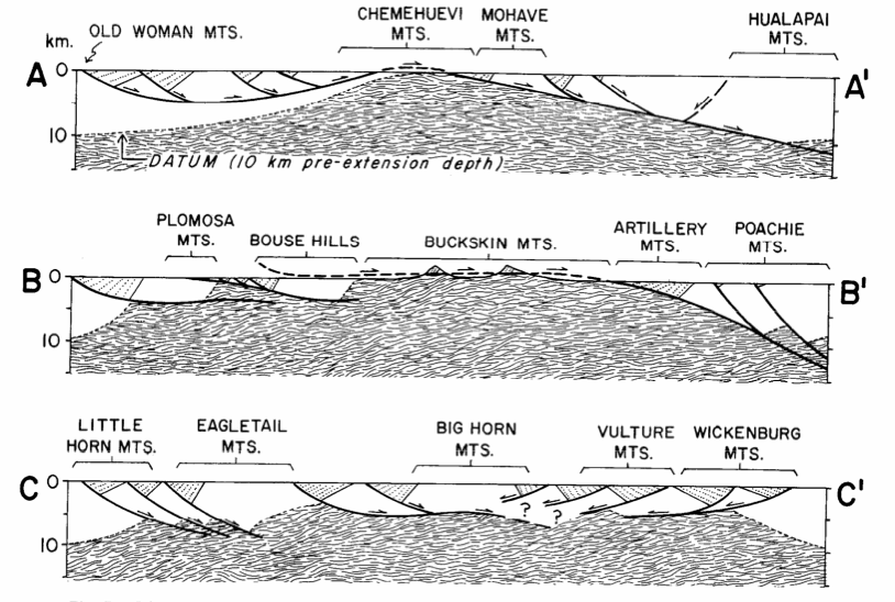 |
Examples of extensional
styles in the Maria Fold and Thrust Belt. Often, extension is
accommodated by small block slip and rotation along a throughgoing basal
detachment fault. This detachment faulting is often associated with
emplacement of metamorphic core complexes. From Spencer and Reynolds
(1990).
|