Paleoelevation of the Sierra Nevada
One approach to finding paleoelevation is to examine oxygen isotope composition
on the lee side of a mountain range, and infer an increase in relief when a
decrease in d18O appears in the isotopic
signal. Chamberlain and Poage (2000) and Poage and Chamberlain (2002) performed
isotope analysis on authigenic smectite in the western Basin and Range. They
postulated that a decrease in d18O with
time would indicate developing relief of the Sierra.
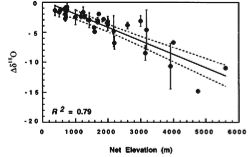
Measurements of present-day changes in isotopic composition (Dd18O)
of surface waters along a change in relief, mostly collected in North America,
South America, and Europe, are well described with an isotopic lapse rate of
about 0.21‰/100 m (Chamberlain and Poage, 2000) (Fig. 1). This relationship
can be used as a proxy for paleoelevation from isotope data, assuming that isotopic
fractionation processes of the past are similar to those of present day.
Figure 1: Surface water Dd18O as a function of net elevation. Samples were collected from the Americas, Asia, and Europe. Note the decrease of Dd18O with increasing elevation. Best fit line is solid, 95% confidence interval dashed. Figure from Chamberlain and Poage (2000).
Chamberlain et al. (1999) showed that authigenic clay minerals represent the isotopic composition of surface waters at the time of clay formation. Thus, a change in isotopic composition with time recorded in these clays should indicate a change in source and/or amount of precipitation. Using isotopic compositions of smectites and geochronology of interbedded ash layers, Poage and Chamberlain (2002) inferred the age of the present relief of the Sierra Nevada. To limit variation in isotopic composition due to changes in precipitation source, they collected samples in regions that receive the majority of their precipitation in the winter, when storms track from the Pacific over the Sierra Nevada (Fig. 2).
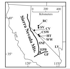

Figure 2: Sample location map (left), and atmospheric
circulation patterns (right) from Poage and Chamberlain (2002). Note that all
samples except EPB were composited into a central Sierra sample. EPB served
as the southern Sierra sample. Also note storm tracks to the study area generally
originate in the Pacific and cross the Sierra.
If the development of topography occurred during the time span observed, one
would expect to see a marked decrease in d18O
for two reasons. First, storms carrying moisture must travel further to reach
the area (concenration effect), and second, storms may cool as they travel over
high topography (temperature effect). However, isotopic data shows a slight
increase of about 0.25 ‰/Ma in d18O
east of the central Sierra Nevada (Fig. 3), and a larger increase of about 0.5
‰/Ma in d18O east of the southern
Sierra Nevada (Fig. 3). These data indicate that the Sierra Nevada have been
at or above their present elevation for at least 16 Ma in the central part of
the range, and 14 Ma in the southern part of the range.
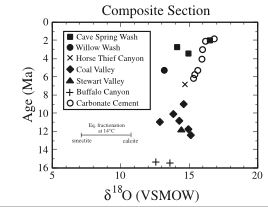
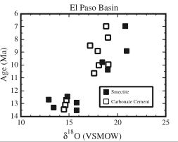
Figure 3: d18O results for the central Sierra (left) and southern Sierra (right). Increase in d18O with time indicates possible weakening of rain shadow and elevation loss (Poage and Chamberlain, 2002).
Factors affecting isotopic composition include changes in surface temperature, changes in the location and isotopic composition of the precipitation source, seasonality of mineral formation, and the decrease in temperature along an elevation gradient (Chamberlain and Poage, 2000). However, Chamberlain and Poage (2000) argue that changes in isotopic composition across an elevation gradient are much larger than changes due to the other factors listed above. In order to rule out the possibility of other variation as the cause of the differences in isotopic composition, one may calculate the expected d18O for a given scenario, and compare it to the data. Poage and Chamberlain (2002) present expected Dd18O for increased elevation of the Sierra Nevada over various amounts of time, and one calculation for climate change. None of these calculations show an increase in Dd18O with time, and, perhaps most importantly, the climate change calculation can not explain the variation in their data. Thus, it appears that the data show a rain-shadow effect over the past 14-16 Ma, and do not support late Cenozoic surface uplift of the Sierra Nevada.
One complication Poage and Chamberlain (2002) do not address is the development of a rain shadow on the lee side of a mountain range. When relief increases, the amount of precipitation reaching the lee side of the range decreases, and d18O becomes enriched (Dansgaard, 1964). Thus, the increase in d18O may indicate a developing rain shadow, rather than a decrease of relief.
Paleoelevation of the Rocky Mountains
Back to Title page
Back to Introduction
Back to Oxygen isotope methods