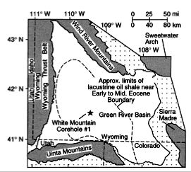
Figure 4: Green River basin and core location map (Norris et al., 1996).
Paleoelevation of the Rocky Mountains
Another set of studies using oxygen isotopes to determine paleoelevation was carried out in the Green River basin of southern Wyoming (Fig. 4). Like the Sierra Nevada, there are at least two views for the timing of Rocky Mountain surface uplift. One group of studies seems to indicate the Rocky Mountains were low until relief developed in the Miocene (i.e., Burchfiel et al., 1992). However, another group of studies indicates high relief in Wyoming throughout the Cenozoic (i.e., Wolfe et al., 1998; Dettman and Lohmann, 2000). The two studies summarized below examined d18O measured on lacustrine carbonates of Eocene age to determine if depleted d18O values indicated snowmelt had drained into the basin, and thus suggest that high peaks surrounded the Green River basin since early to mid Eocene.
Figure 4: Green River basin and core location
map (Norris et al., 1996).
Norris et al. (1996) used core samples of microbial carbonates in lake sediments
of the Green River basin to study the d18O
signal of early to middle Eocene age (Fig. 4). Data from the carbonates showed
d18O values around -4‰ PDB on average,
but showed spikes of depleted d18O as
low as about -15‰ (Fig. 5). Carbonates with d18O
around -15‰ PDB would be in equilibrium with water of d18O
about -13 to -20‰ SMOW (Norris et al., 1996).
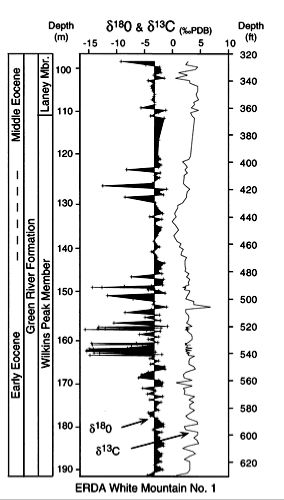
Figure 5: d18O as a function of depth and age. Note the very negative values of d18O at depths of approximately 125-130 m and 148-165 m, which may indicate an influx of snowmelt to the Green River basin (Norris et al., 1996).
These much depleted samples were interpreted as evidence for periods in which
snowmelt reached the basin(Norris et al., 1996). They argue that this snowmelt
must be runoff from surrounding peaks, rather that snowmelt from basin elevation.
Palms of Eocene age, found near the lake, suggest a mean annual temperature
greater than about 5oC (Greenwood and Wing, 1995), which is too warm
for significant snow accumulation (Norris et al., 1996). Further, it is believed
that the lake was in a closed basin (Norris et al., 1996). Norris et al. (1996)
reasoned that if snowfall significant enough to produce melt water to reach
the lake and produce the d18O signal occurs
where the mean annual temperature is about 0oC, and assuming a lapse
rate and mean annual temperature of 6.5oC/km and 18oC,
respectively, mountains with significant snowfall would have been at least 2800
m above the lake, or paleoelevations of ~3000 m or greater.
One uncertainty in the data presented by Norris et al. (1996) may be carbonate
alteration during diagenesis, which can lead to anomalous, depleted d18O
signals. However, because the depleted d18O
signal occurs in many different rock types which did not experience deep burial
during diagenesis, Norris et al. (1996) believe the isotopic signal represents
snowmelt rather than diagenetic alteration.
In a second study, Morrill and Koch (2002), using samples from the same core
as Norris et al. (1996), looked for the effects of alteration on d18O.
They found that unaltered shells of Eocene age indicated d18O
of the lake water was about -7 to -12‰ SMOW, but altered shells indicated
more depleted d18O values (Morrill and
Koch, 2002). Although Morrill and Koch (2002) point out that their samples may
have missed the short-lived fluxes of snowmelt inferred by Norris et al., they
favor the view that lake waters were not significantly depleted in d18O,
and reason that the oxygen isotope signal is insufficient for assessing paleoelevations
around the Green River basin.
The studies carried out in the Green River basin summarized above illustrate the uncertainties in d18O methods, and how two different conclusions can be reached using samples from the same locality.
Back to Title page
Back to Introduction
Back to Oxygen isotope methods