Rio Grande Rift Gravity
 Regional Gravity
This
figure shows the long wavelength Bouger anomaly from a University of Texas,
El Paso and DNAG gravity data. There is a gravity low that trends
SW-NE oblique to both the rift and Jemez lineament. The low
velocity feature also follows this trend and correlates to the transition
zone between the Rio Grande Rift and the Colorado Plateau (Slack et al
1996) and the SKS splitting measurements
of the rift (Gao et al 1997). This direction contrasts with the N-S crustal
thinning, heat flow and topographic features. It is though that this may
be the tectonic expression of an earlier phase of extension (Slack et al
1996).
(Figure from Slack
et al 1996)
Back to Index
Gravity Along the Seismic
Profile NW Espanola Basin, Abiquiu

The observed Bouger Anomaly
(+ symbols), regional (dashed line) and calculated gravity are shown along
the Abiquiu profile. The solid line is the sum of the calculated and regional
anomalies. The model is based on contraints on geologic observations and
the seismic profile. Density
is in kg/m^3 and was estimated from seismic P-wave velocities (Baldridge
et al 1994).
Constraints in the model
use thicknesses of formation at major fault outcrops and the assumption
that the El Rito Formation is horizontal and from the seismic profile thicknesses
of units. There is some disagreement between the gravity model and the
seismic profile at the western end (Balridge et al 1994).
(Figure from Baldrige et al 1994)
Back to Index
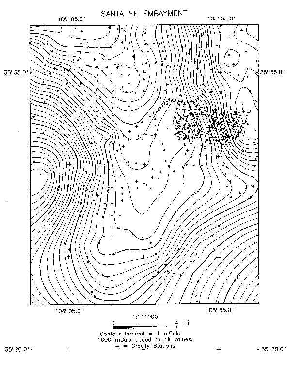
Gravity of the Santa Fe Embayment,
Espanola Basin

The figure shows the observed
Bouger anomaly for the Santa Fe Embayment. The 932 gravity stations (+
symbols) were collected during SAGE 1998 and
1997 field season, from Cordell 1979 and others. The 1998 contribution
of 336 gravity stations, were taken using G-962 and G-22 Lacoste and Romberg
gravimeter and a Scintrex CG-3/3m autograv.
The Santa Fe Embayment is
located in the sorthern portion of the Espanola Basin. The basin is bounded
to the east by the Sangre de Cristo Mountains, which are made of Precambrain
basement (1.6 - 1.8 by). The western edge of the basin is bounded by the
Jemez volcanic field that included the Valles Caldera.
Back to Index
Depth to Basement of the Santa Fe
Embayment, Espanola Basin
A depth to interface was performed
using well data constraints and outcrops of the Precambrian surface. The
results show something interesting in that what was expected was a general
opening of the embayment to the north as the observed Bouger map alludes
to. Though this figure shows that there might have been a lake present
to the embayment moving south.
It is unknown whether the
basement topography has been imaged or rather the Paleozoic/Mesozoic boundary.
The density contrasts between the basement and the sedimentary rocks are
relatively small. Go to a table of physical properties.
Back to Index


