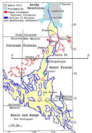
A rift is an area where there is an elongated topographic depression over an area that has been extended. The Rio Grande Rift consists of a series of north-south asymmetrical basins that are oppositely hinged. These basins extend from Leadville Colorado to Chihuahua Mexico, a distance of more than 1000 km. The northern basins consist of half graben accommodation zones, while the southern rift resembles the basin and range in the style of deformation. The rift separates the physiographic provinces of the Colorado Plateau from the Great Plains (Olsen et al. 1987).
The Rio Grande Rift is located along a north-trending zone of past deformation during the Paleozoic (Ancestral Rockies) and during the Tertiary (Laramide orogenies). This tends to complicate geophysical signatures of the rift.
Volcanism in the Rio Grande Rift has been minor compared to other continental rift systems. The Jemez lineament represents the tertiary volcanics during rifting and is considered to follow past weaknesses in the lithosphere. It has a northeastern trend that intersects the rift in northern New Mexico at the Jemez mountains. Within the Jemez mountains is the Valles caldera complex. Basaltic volcanism has occured in the Jemez mountains between 15 Ma and 10 Ma with the possibility for the latest being at 7 Ma (Aldrich 1986).
Rifting proceeded in two distinct episodes. The first began as early as 30 Ma and continued till about 20 Ma. The latest period of extension resumed about 10 Ma and has continued active rifting until about 3 Ma.
(Figure adapted from Baldridge et al 1995)

Rifting may occur through 3 different mechanisms shown to the right. The first method is where the hot asthenosphere forces up the lithosphere creating uplift and increased volcanism. The second method involves forces at the edges of the lithosphere pulling itself apart. There tends to subsidence and thinning of the crust. The asthenosphere then rises to fill the void left by the thinned lithosphere. The third mechanism involves a piece of the lithosphere delaminating or peeling away from the crust causing upwelling of hot asthenosphere to the base of the crust (Olsen et al 1987).
(Figure adapted from Olsen et al 1987)
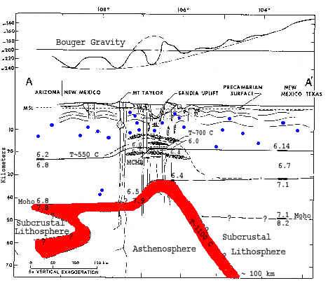
This is a cross section of the Albuquerque - Belen Basin showing the upwarp of the moho parallel to the surface of the rift. The thickness of the lithosphere varies from the Colorado Plateau on west through the rift and to the east in the Great Plains. The thickness under the Colorado Plateau is about 45 km and under the Great plains there is 50 km, while under the rift axis there is only about 33 km of lithosphere (Olsen et al 1987).
The blue dots represent seismicity of the rift. The numbers at the boundaries, seismic velocity. Beneath the axis of the rift there is believed to be mid crustal magma bodies, represented in the figure by black ellipses. Seismic velocities are sensitive to temperature, higher temperatures mean slower velocities. There are low Pn values (7.6 - 7.8 km/s) below the rift which implies that the asthenosphere may be in contact with the base of the crust. Lower crustal P wave velocities are also low (6.4 - 6.5 km/s), this suggests high crustal temperatures (Olsen et al 1987).
At the top of the figure is the Bouger gravity anomaly across the rift and the regional gravity. What it shows is that there is a gravity negative over the rift next to gravity highs at the sides. Gravity is sensitive to density variations. There will be a gravity high over materials that are very dense (ie. volcanics, precambrian basement) and a gravity low over materials that are less dense (ie. sediments and onconsolidated material).
(Figure from Olsen et al 1987)

The SAGE Program (Summer of Applied Geophysical Experience) is an educational organization dedicated to teaching undergraduates and graduate students about field geophysics in a research focused way. The SAGE program has operated for 17 years investigating the Rio Grande Rift. Students investigate the structure and tectonics of the rift. They also have investigated an environmental restoration site at the Los Alamos National Labratory (LANL) and a groudwater investigation in the Espanola Basin. Students have the opportunity for hands-on experience with different geophysical techniques, including seismic reflection and refraction, magnetics, electromagnetics and gravity. SAGE is sponsored by the LANL branch of the Institute of Geophysics and Planetary Physics, University of California and partially supported by NSF's Research Experience for Undergraduates Program.