Gregory Tucker

Ph.D. Geosciences, Penn State, 1996
Professor, Department of Geological Sciences
E-mail: gtucker@cires.colorado.edu
Office: Benson 246D
Phone: 303-492-6985
Web: Tucker Research Group
Research Interests
Landscape evolution, tectonic geomorphology, impacts of climate change on hillslope and fluvial systems, numerical simulation of landform development.
Current Research: Measuring fire impacts with laser technology
Forest fire impacts can be felt long after the flames have been quenched. Loss of forest-floor litter and changes to the soil can enhance runoff during heavy rains, potentially leading to flooding. Greater runoff, in turn, carries ash and sediment downhill and downstream, potentially contaminating water supplies, filling reservoirs, modifying stream geometry, and altering aquatic habitats. Vulnerability to runoff and erosion can persist for months to years following an intense fire, yet our knowledge of the sources of eroded material is limited by the difficulty in measuring sediment sources and sinks. In the past, researchers have had to rely on sediment trapping and similar methods to gauge the erosional yield following a wildfire; these methods, in addition to being highly labor intensive, provide only sparse, integrated measurements of soil loss.
CIRES Ph.D. student Francis Rengers and I ran a field experiment in measuring post-wildfire erosion with groundbased laser-scanning technology. The study followed the 2010 Fourmile Canyon Fire, Colorado’s most costly wildfire at the time. Working with a U.S. Geological Survey team, who installed rainfall- and runoff-monitoring equipment on a ridge several miles west of Boulder, Colorado, our team used a high-precision laser scanner to obtain detailed terrain measurements. We collected five surveys over 20 months.
The surveys revealed several surprises. Although the most obvious sign of erosion was scour of the site’s main channel, the majority of sediment actually derived from widely distributed erosion of a relatively thin (several-centimeter) soil layer. Over the 20-month period, sediment yield gradually decreased, while surface roughness increased as erodible soil patches were depleted. The correlation between runoff force and erosion was surprisingly subtle; instead, the erosion patterns were notably correlated with soil thickness and terrain smoothness. Overall, the study demonstrates ground-based laser scanning can document spatial patterns of post-fire erosion efficiently, non-destructively, and with centimeter- scale precision. The results will provide rich fuel for the next generation of post-fire runoff and erosion models.
Publications
Click here for a complete list of published works »
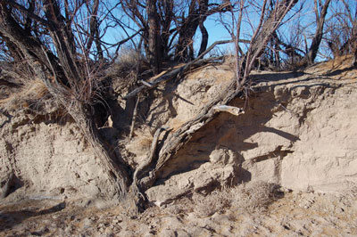
Riverbank erosion has re-exposed these buried saltcedar trunks in the floodplain of the Rio Puerco, New Mexico. Photo credit: Greg Tucker.
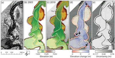
A typical segment of the Rio Puerco arroyo: a) Quickbird II satellite; b) shaded relief map of 2005 lidar data set; c) shaded relief map of 2010 lidar; d) ground-elevation differences between 2005 and 2010, with cool colors showing positive topographic change (aggradation), warm colors showing negative change (erosion), and arrows indicating sections of the arroyo wall that collapsed as large blocks; and e) map of differencing uncertainty. Image credit: Mariela Perignon/CIRES; reproduced from Perignon et al. 2013.