 |
|
A winning proposal for the Innovative Research Program, 2007: Using Radio Transponder Tagged Clasts to Test Fluvial Sediment Dispersion TheoryInvestigators: D. Nathan Bradley and Gregory E. Tucker Introduction Contaminant transport and dispersion occur in environments ranging from the troposphere down to aquifers. A mathematical description of the motion of contaminants is critical to accurate hazard prediction and effective remediation. Many environmental pollutants travel in the solid phase, adsorbed onto sediment grains and transported by streams. For example, during the cleanup of the Rocky Flats Nuclear Weapons Plant, researchers found that plutonium and americium were not traveling in solution, but instead adhering to mineral grains and being transported by streams (Clark et al, 2006). Despite the critical environmental role of waterways, our understanding of the dispersion of fluvial sediment grains is rudimentary. We propose to develop a novel method of tracking sediment in order to test a recently developed hypothesis about the nature of fluvial sediment dispersion. Verifying this hypothesis will contribute to a quantitative description of contaminant transport and represent a step towards a statistical model of sediment transport that is important to applications such as cosmogenic radionuclide budgeting and grain weathering. Some form of the familiar advection-diffusion equation (ADE) is typically applied to describe the transport and dispersion of contaminants, but there is evidence that this approach is not always adequate. Studies of the dispersion of pollutants through heterogeneous aquifers have shown that the ADE often does a poor job of predicting the spatial distribution of the contaminant and the temporal evolution of the contaminant plume. Figure 1a shows the spatial concentration of a chemical tracer in a heterogeneous aquifer from the Macrodispersion Experiments (MADE) conducted at Columbus Air Force Base in Mississippi in the 1990's. The tracer plume exhibits a peak concentration and a long leading tail that are very poorly described by the ADE. This type of behavior is typical of transport in heterogeneous porous media and is known as anomalous dispersion (Herrick et al., 2002). Anomalous dispersion occurs in a variety of dispersive systems and there are theoretical and empirical reasons to believe that anomalous dispersion of sediment grains may be common in stream networks. 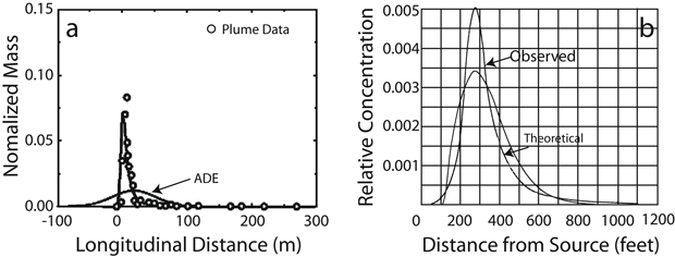 Figure 1. a) The spatial concentration of a chemical tracer in a heterogeneous aquifer. Modified from Herrick et al. (2002). b) Tracer concentration profile from Sayre and Hubble's (1965) study of the dispersion of radioactive sand in the N. Loup River, NB. In both examples, the ADE-based model underestimates the peak concentration and the concentrations in long leading tail of the plume. In the 1960's, the USGS tracked the motion of radioisotope tagged sand in the North Loup River, Nebraska. Their results are very similar to those from the MADE tracer tests. Figure 1b shows one tracer concentration profile from Hubble and Sayre (1965) along with their model. The observed concentrations differ from the model in the same way that the MADE results differ from the ADE-based model. The peak and the downstream tail of the plume both contain a higher fraction of the tracer material than the models predict. These models would under-predict the hazard from a highly toxic contaminant. Hypothesis and Objectives Recent theoretical work (Bradley and Tucker, 2006) also supports the hypothesis that fluvial sediment dispersion may be similar to the anomalous dispersion of contaminants in groundwater if the likelihood that some particles become trapped in sedimentary deposits for long periods of time is sufficiently high. If this is the case, a mathematical description other than the ADE may be required to adequately predict the distribution of a contaminant. The simplest and most direct way to test this hypothesis is with a time series of the positions of uniquely identifiable tracer particles. Because anomalous dispersion is most evident in the tails of the spatial distribution, an experiment like this requires thousands of tracers and a high recovery rate. Until recently, this has been difficult in a long-term study because tracers such as magnetically tagged stones must be dug out of the streambed to be identified (e.g. Ferguson et al., 2002). The recovery process is time consuming and it disturbs the system we wish to study. Passive Integrated Transponder (PIT) tags are a relatively new technology that have been used extensively to monitor migrating fish but only recently as tracers in fluvial systems. A PIT tag is a passive radio transponder encased in small (~3 cm) cylindrical glass case. When the antenna on the detection system passes nearby, the electric field generated by the antenna induces a current in the tag that gives it enough power to transmit its unique identification number to the receiver. Depending on the size of the antenna, the detector has a lateral range of about of 1m and can detect buried tracers down to a depth of about 1m. Manufacturers estimate that PIT tags will function for 50 years (Lamarre et al., 2005). We propose a one-year pilot study of the feasibility of using PIT tagged clasts as tracers of fluvial sediment dispersion. We will implant PIT tags in about 1,000 rocks and release them in Half Moon Creek, a small gravel bed river that drains Mt. Elbert and Mt. Massive, southwest of Leadville, Colorado that has been extensively studied (Mueller and Pitlick, 2005). We will obtain the necessary detection equipment and re-locate the tracers after each high-flow event over the course of the study. From this pilot, we will evaluate 1) the optimal technique for preparing a large number of tagged particles, 2) antenna design and tuning and other strategies for maximizing recovery rates, and 3) strategies for surveying the tracer position in the most efficient manner. Works Cited
|