 |
|
A winning proposal for the Innovative Research Program, 2008: A new method to test the accuracy of channel erosion rates determined from cosmogenic radionuclidesInvestigators: Scott W. McCoy and Gregory E. Tucker - CIRES & Dept. of Geological Sciences Objective: We propose a novel test of a method for measuring rates of channel incision over thousand-year timescales. The method uses the gradual accumulation of cosmogenically produced radionuclides (CRNs) in near-surface rock as a measure of the speed of surface lowering. The assumptions required in applying this method to active bedrock channels have never been tested. The test we propose takes advantage of a one-of-akind independent data set of channel incision rates near active earthquake faults in the Italian Apennines. Background: A central focus of geomorphology has been the explanation of the diverse suite of observed landforms in terms of the physical processes that have created them. Much of the recent progress has come from the development of geomorphic transport laws 1. These physically based rules express mathematically how a particular process moves mass down slope and changes the elevation of the surface of interest. By explicitly representing the dependence of mass transport on the parameters controlling the process (e.g. channel gradient or water discharge) it is possible to explore how changes in external variables such as land use, climate or tectonics would be manifested in the landscape. Studies have shown that the sculpting of dramatic ridge-valley topography in mountain ranges mainly derives not from rivers, but rather by the occasional, violent surges of rock and mud known as debris flows2. Yet there is not an agreed upon geomorphic transport law for what controls the rate of channel incision by debris flows. This makes it very difficult to predict how steep portions of a landscape will respond to changes in climate and tectonic variables or what the consequence of changing land use would be. Recently workers have published speculative geomorphic transport laws for debris flows3, but they remain untested due to the lack of necessary data. Field measured erosion rates are essential to validate and further develop debris-flow geomorphic transport laws. Unfortunately, in these steep debris flow channels the common methods of using dated remnants of the previous channel location are not possible due to lack of preservation. The only other viable method to obtain the erosion rate at a point is to use rates determined from the concentration of CRNs in the bedrock of the active channel. This method has not been favored due to the difficulty in constraining how the accumulation of CRNs in the bedrock has been affected by shielding due to an unknown history of sediment cover. We are aware of only two studies4,5 that have used this method on bedrock channels, and both studies simply assume that the sediment cover has been negligible over the past 102-103 years due to the current channel being devoid of sediment. We would like to test this assumption. If it can be shown that this assumption is valid is steep, actively incising channels, we would have grounds to move forward in using this method in similarly steep and active settings where the erosion rate is not known. What is Innovative? This will be the first time that active channel erosion rates derived from CRNs have been validated with an independent measure of erosion rate that averages over similar time scales of 102-103 years. This validation is possible due to two features of our proposed field site in the Italian Apennines. First, the debris flow channels are in local equilibrium with the rate of base level lowering due to throw on the normal faults that they cross. Equilibrium is implied by the smooth channel profile over the fault and lack of preserved scarp in the channel. This indicates that the local rate of channel incision is equal to the throw rate on the fault. Second, Palumbo et al6. precisely documented the slip history over the last 12 ka using 36Cl on the Magnola fault (figure 1a). In addition, our colleagues are currently in the process of collecting similar data for five additional faults. This fault displacement data provides unprecedented documentation of slip history over precisely the time scale that it is possible to measure erosion rates using in situ CRN (102-103 years). This unique match of timescales makes it possible to test the accuracy and precision of our proposed CRN determined erosion rates. Research Plan: We will measure channel erosion rates, in catchments with massive bedrock where there are clear signs that debris flows are the dominant erosion process by using methods that measure the surface concentrations of CRNs to determine erosion rates. The catchments where we will be making these measurements are limestone so the primary target will be the CRN 36Cl. The production pathways and production rates for 36Cl in calcite are well understood and documented7. Our sampling strategy for this pilot study will be to take three samples in close proximity to the fault from each of the five channels where highresolution throw rate data have been obtained. The three CRN determined erosion rates will then be compared to those determined from the fault throw data and to each other to check for accuracy and reproducibility. From our reconnaissance work the reaches where the channel crosses the fault are steep and have no sediment cover, so sediment cover in the recent past is unlikely (figure1b) and these channels meet the assumption we are trying to test. 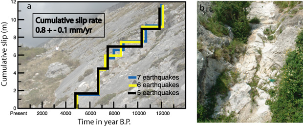
Figure 1. a) fault slip history from Palumbo et al.6 overlaid on a picture of the dated scarp. The graph shows three alternative interpretations of their data; despite the +/-1 uncertainty in the number of earthquakes, the fault slip history is exceptionally well constrained. Similar data will be available for 5 other faults within the next ~6 months. b) Photograph of an example reach where bedrock sampling would take place. Importance: If we can demonstrate that through appropriate site selection CRN-derived active channel erosion rates are accurate and reproducible, we and others will have grounds for using this unconventional technique in a full-scale study of channel erosion rates across similarly steep and active channel networks. A subsequent full-scale study of debris flow channel erosion rates would provide the data that is necessary to better understand how steepland evolves. References
|