
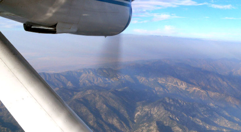
Photo courtesy Raul Alvarez, NOAA
CIRES Fellow Mike Hardesty and colleagues
studied
ozone levels in the Los Angeles Basin
Drifting dirty air
City air ends up in pristine mountains, neighboring states
By Jane Palmer
The most striking feature of Asia's Himalaya Mountains — their breathtaking height — makes Himalayan glaciers far less vulnerable to melting than their lower-elevation counterparts.
It's cold at 18,000 feet and above. Really cold. All the time.
That may seem perfectly obvious, said CIRES Fellow Richard Armstrong, but the basic facts appear to have eluded many people.
What happens in Los Angeles doesn’t stay in Los Angeles—at least when it comes to air pollution. When CIRES Fellow and NOAA scientist Mike Hardesty and his team flew the Twin Otter research aircraft over the mountain ranges east of the Los Angeles Basin, they found the city’s ozone, a product of industrial emissions and vehicle exhaust, lifted up into the tree-decked hillsides.
“One might think the pollution is going to be all on the Basin floor down below,” said Hardesty, one of the five-member flight team that included CIRES scientist Christoph Senff and NOAA scientists Andy Langford, Raul Alvarez and Robert Banta. “But you can also have high ozone in those nice forest parks on the slopes around L.A.”
Surrounding forests and mountains are not the only regions tainted by
L.A.’s poor air quality, Hardesty said.
Based on their measurements and calculations, the scientists believe the elevated plume could have been responsible for high ozone levels at Canyonlands and Mesa Verde nearly 1,000km to the east. “So we are actually seeing the influence of the L.A. region in Utah and Colorado,” Hardesty said.
The team travelled to Los Angeles during summer 2009 to look at the flow patterns of air from the L.A. Basin and to prepare for CalNex 2010 (see The lowdown on CalNex). On several four-hour flights above the boundary layer—the layer of air immediately above the Earth’s surface—the scientists used an array of cutting-edge instruments to map out the ozone and aerosol structure within the Basin.
Lidar measurements (see Understanding lidar) over the San Gabriel Mountains revealed some ozone funneled out of the boundary layer into the free troposphere—a phenomenon known as the mountain chimney effect. As the sun heats the mountain ridges, the air around them becomes warmer than the typical air temperature at the same elevation. This heated air then rises, pulling up air from below and some of the ozone with it.
As this pollution funnels into the free troposphere, winds can carry it to other states, Hardesty said. “In terms of the states having to conform to EPA regulations, some are very anxious to know how much of the air pollution is imported,” he said. “You can’t do much about the stuff that comes in.”
The team followed up their study with further experiments as part of CalNex 2010. During both the 2009 and 2010 studies, the Twin Otter also boasted a new instrument to measure a variety of pollutants, including nitrogen dioxide, a key contributor to ozone formation. “By looking at the precursors as well as the ozone, we have a nice synergistic experiment that lets us look at some of the sources,” Hardesty said.
In 2010, the team also added a small Doppler lidar to measure the winds in the boundary layer below the aircraft. Specifically, the team hopes to put some hard numbers on the movement of air pollutants flowing both up the sides of mountains and through the passes. “We have demonstrated that lofting happens,” Hardesty said. “What we want to do next is quantify how much pollution lofts up into the free atmosphere during air pollution episodes.”