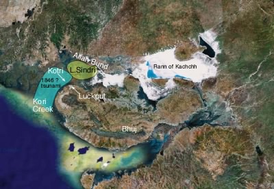
19th June 1845 Lackput earthquake
Mrs. Derinzy's letter to Captain Nelson 1846 The Nelson letter, extracted below (see pdf) is incorrectly cited as Nelson (1846). On the last page of the Q.J. Geol. Soc. 1846 (page xii) under the entry for meetings of December 17th the true author is found to be Mrs. Derinzy who at an undisclosed date wrote the letter to Captain Nelson of the Royal Engineers: It was read in extract form on December 17th. "Extract from a Letter concerning a Depression lately produced in consequence of an Earthquake in Cutch, by Mrs Derinzy."

The archivist at the Geol. Soc. has found no record of the original letter, which presumably contains further information not considered of interest by the President in 1846 The extract starts with the puzzling remark about McMurdo (this must be a different McMurdo from the MacMurdo who was the British Resident in 1819 at the time of the Allah Bund earthquake, who died of cholera in 1820). Further research is needed to determine the relationship between Derinzy, McMurdo and Nelson described in this extract. Mrs Derinzy was possibly the wife of Lt Col. Bartholomew Vigors Derinzy (d.1862 aged 73, Gentl. mag. 12, 1862). Nelson may have been the geologist Richard John Nelson (1803-1877, Royal Engineers) who wrote on Bermuda geology and gun carriages etc.
Q. J. Geol. Soc. 2, 103, (1846 )
3. Notice of an earthquake and a probable subsidence of the Land in the district of CUTCH near the mouth of the KOREE, or Eastern branch of the INDUS in June 1845. Extracted from a Letter to Capt. NELSON, RE
[Communicated by the President]
"One of Capt. McMurdo's guides was travelling on foot to him from Bhooj. The day he reached Luckput there were shocks of an earthquake, which shook down part of the walls of the fort and some lives were lost. At the same time as the shock the sea rolled up the Koree (the eastern) mouth of the Indus, overflowing the country as far westward as the Goongra river (a distance of twenty English miles), northward as far as a little north of Veyre (forty miles from the mouth of the Koree), and eastward to the Sindree Lake. The guide was detained six days (from June 19th to 25th during which time sixty-six shocks were counted. He then got across to Kotree, of which only a few small buildings on a bit of ground remain. Most of the habitations throughout the district must have been swept away, the best houses in Scinde being built of sun-dried bricks, and whole villages consisting only of huts made of a few crooked poles and reed mats. The guide travelled twenty miles through water on a camel, the water up to the beasts body. Of Lak nothing was above water but a Fakeer's pole (the flagstaff always erected by the tomb of some holy man); and of Veyre and other villages only the remains of a few houses were to be seen.
There are said to be generally two earthquakes every year at Luckput. The Sindree Lake has of late years become a salt marsh."
Platt [1962] gives a muddled summary of the above which is best ignored. (He infers the guide to be traveling toward Bhuj, Nelson to be the writer and a subordinate of MacMurdo (they were the same rank), and assumes without justification that the dates refer to 1819. In fact MacMurdo was in Bhuj in June 1819 and died in 1820. The passage clearly describes the guide travelling from Bhuj to Veyre to join McMurdo (no 'a') allegedly 19-25 June 1845 and we currently have no reason to doubt this.
.

The following archives researched by Stacey Martin remove remaining uncertainties about the reality of this June 1845 event, although the original source is given in neither of the accounts..
The Englishman and Military Chronicle, Friday, 1 August 1845 [Quoting the Gentleman's Gazette, July 19]. "Letters from Cutch mention that there had been an earthquake at Luckput bunder, which had had the remarkable effect of deepening,
no less than twelve feet, the Eastern branch of the Indus, which passes by that town. This branch, is will be remembered, was
formerly navigable but was choked up by the Earthquake of 1819, as described by Sir Alexander burnes in his Memoir of the Indus. Fourteen or fifteen houses were thrown down at Luckput by the shock, and between the 15th and the 25th ultimo, other frequent slight shocks were felt."
The Bengal Hurkaru & India Gazette, 26 August 1845 Translated from the Duancindu, for the "Bombay Courier"
A correspondent at Kutch in Bhooj informs us of an earthquake lately felt at Luckput Bunder by which 15 or 20 houses were
destroyed. The river Indus has by this earthquake been widened to the Scindian frontier near Quettah (?possibly Sundo?) and a portion of the river, which had been choaked (sic) up by the earthquake of 1819, has now been become navigable.