Summary
of 1819 Allah Bund Earthquake materials from Burnes(1828)
Full Memoir html pdf Full supplementary Memoir html pdf Map pdf
Burnes,
A., (1828) A memoir and supplementary Memoir of a map of the Eastern Branch
of the Indus. Fol., Bombay. (The original document is listed by T.H. D. LaTouche
on page 73 of his 1917 Bibliography of Indian Geology and Physical Geography, Geol. Surv. India, Calcutta pp 571. The number of
pages of the original folio and its location, are not given, but it is probable that the ms. lies in
the Asiatic Society of Bengal and was borrowed and transcribed at Oldham's
request in 1924, by Alexander Heron,
then DG of the GSI).
The
following extracts are relevant to the 1819 Allah Bund earthquake, copied from
the 70 page typescript deposited by R. D. Oldham in the Geological Society of
London in 1924. (Geol. Surv. Lond.
archive reference LDGSL 767). The
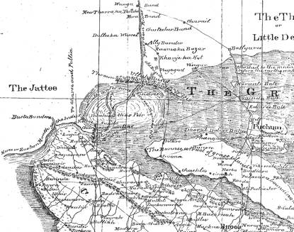
NW corner of this map is shown below, and later, a simplified version. Two 2007
GoogleEarth maps are shown of the
previously ignored, Kaera or Kaeera nulla.
Click on maps for larger views:
Memoir: March
1827, Camp at Lucput
I
am not aware of the breadth of the channel at Ullah bund previous to 1819 but
it is at present only 120 feet, and this, with only a depth of 15 feet--
The
Ameers of Sind acknowledge the right of the Cutch Government to a nulla called
"Kaeera", which
is above Ullah bund, and the place where they collected taxes to the very day
of the earthquake in 1819 [Note:
It is a singular fact that the boat belonging to the Tanna at Sindree was left dry in this nulla the
day after the earthquake and, from there being no water to float it out, has
been broken up and sold].
The distance from Lucput to Ullah bund is by water upwards of fifty miles,
though it is much less in a straight line. The river is, at the narrowest part
about 100 yards wide and at the widest, which is Sundo about two miles; opposite Lucput it is nor more than 250 yards and at Ullah
Bund it is only 40
yards. Its depth varies from two
to three fathoms of water in all places except Sundo where it is only two feet
at low, and three, at high tide. Its banks throughout are low and muddy and
above the Misree Peer
(which is about ten miles from Lucput) intersected by numerous nullahs some of
which are from six to eight feet deep. The two principal ones are Kotro on the south side and Chungasir on the north, both within two miles of
each other and remarkable as being close to what formerly was a ford across
this branch of the Indus.
Sundo extends up and down the River for a distance of two
miles and lies a little higher up than Chungasir. The
River is here about two miles broad, that is the channel, for the water expands
on both directions and the appearance is no longer that of a River, but of
a sea and instead of nullas to impede the approach to the banks we have a sheet
of water on both sides about half a foot deep, covering a clayey soil and
extending many miles both to the east and west. The earthquake is also
said to have made this alteration as it was before it equally deep and no wider
than other parts of the River.
Sindree is situated on the Eastern Bank of the river and is a
ruined fort of 150 feet square with four towers and built of burnt bricks. Three of the towers had fallen down and
the only one now standing (and it is in a precarious way) is the northwestern
on which there is a flag staff.
The walls have been two feet thick but this is impossible to say how
now. The tower that stands is
about 18 feet high and is near the gateway which was on the west side. There is not a vestige of a house
remaining and the interior of the fort has become a tank and is filled with
salt water, in which there are fish. The only dry spot near the place is where
the walls actually stand and which is kept so by the bricks being piled on one
another. The river runs close under its walls and it must have been a very
valuable position for the government to collect its taxes when the road between
it and Cutch, as well as Sind, was open.
A
black speck on the horizon to the northeast at about a distance of 5 miles,
points out the position of Ullah Bund, the embankment thrown up by nature in the earthquake of 1819,
previous to which period there was not a single trace of it. It runs due East
and West and is said to extend twelve miles Eastward and about two
Westward. It is about 10 feet above the level of the River which is at present
from 12-15 feet deep and; is composed of soft clay and covered all over with
shells and has quite the appearance of having been broken through by some
torrent. At present the opening is only from 30-40 yards wide but there are marks
of the current having extended during the swell some 200-300 yards to the
Westward, while the Eastern side now presents a bank of ten perpendicular feet
and looks as if it had been cut by manual labour. The bed of the River is the
same as the banks, clay, and the whole soil around appears to be a mixture of
it and sand.
A short distance
above bund is Kaera nulla, a position where the Cutch Government collected taxes before the
earthquake and the extremity of their territory on the North. The merchandise
was crossed over it in small boats and the beasts of burden that carried it to
the nulla, swam across and, being again laden, proceeded to Sindree. At this
(from the dry land on both sides of it) the stream again resumes the appearance
of a River and though narrow is quite navigable even at this late season of the
year (March).
There
was even at a very late period i.e. 20 years ago, the remains of an extensive "wand" at Chungaseer and the natives still point out the site of a village
on Sundo which they pretend to know by the remains of some trees.

Simplified map
of NW corner of Burnes April 1828 map in which he depicts the Allah Bund
concave south
Supplementary
Memoir: Lucput August
1828
At Ullah Bund the river is without alteration except at
its mouth where it is certainly wider and which is to be accounted for by the
west bank being partly washed away as, instead of sloping up, it is now, like
the eastern one, perpendicular. I
sailed two miles higher up than when last here and found the water to decrease
gradually from two and a half fathoms [7.5m] to four feet [1.3m], and
ultimately terminate in half that quantity [0.6 m] which I was informed
continued up as high as Chuteetur, which is above Ally
bunder and twenty miles
up where the water comes from the Goonee river, and to which the Doondees, or
flat bottomed boats, could now approach.
The
greater distance which I ascended the river gave me a clearer view of the
effects of the Nora as the flood of November 1826 is so
called. The banks on both sides
are of clay, and as the river comes directly from the north almost without
windings, and the sides are perpendicularly cut by the violence of the current,
I can compare it to nothing so correctly as a canal, nor does its breadth when
a little way up destroy the resemblance, being only sixty feet wide, as I found by actual measurement.
I
might have extended my journey farther up but as I had reached the shallow
water and fallen in with a boat from Raoma Ka Bazar, the first Scindian village, I judged it more prudent
to say for myself non amplius ibes
than to encounter any of the subjects of the Ameers and, jumping on shore, I
retraced my steps to the Ullah bund.
This
natural mound so called runs east to west and is certainly the most singular
effect of the great earthquake of 1891. It does not appear to the eye more
elevated in one place than another, and is a flat tract about eight to ten feet
above the level of the water with a surface of saline soil covered with decayed
tamarisk bushes, having, its elevation excepted, all the appearance of other
parts of the Runn. I found,
however, that the mound extends farther than I had before stated for I have
been credibly informed by many natives that it stretched as far east nearly as Puchum
island, a distance from the river of
24 miles, and crosses the road over the Runn from Loona to Raomo Ka Bazar, a
distance 16 miles south of the latter place, where it is about a mile broad,
and during the wet weather even made a halting place.
To
the westward it is said to extend to Gharee, a distance of 18 or 20 miles which
would make its total length nearly fifty miles. It is impossible to define so correctly its breadth as it
meets the land, but all describe it of the same nature as that in the
neighborhood of the river till near Khanje-Ka-Kot within two miles or so of the
Raoma Ka Bazar, which 16 miles
distant from the mouth of Ullah Bund, where the country is cultivated.

GoogleEarth
February 2007 image of the entrance to the Allah Bund.
While
traversing the bund, I discovered the remains of an artificial mound on the
eastern side of the river about 2 miles from the mouth of the Kaeera nulla which runs into the river at Ullah bund, and which I learnt was another memorial of that
public spirited and enterprising chief Futtih Mahommed, it having been thrown
up in his reign to prevent the south westerly winds blowing the water on the
road to and from Cutch to Sindree and impeding thereby the passage of
merchandize during the monsoon.
The late alterations have of course
destroyed it and this road between Cutch and Sind cannot now be said to be open
in the rainy season. The old road
is underwater and the circuitous one from Loona is always closed upon rain
falling during the southwesterly winds.
The shallow part
of the river called "Sundo" where the channel widens to two miles is still
without alteration. It may be recollected that I pointed this out as the
effects also of the earthquake for, previous to it, it was as deep as
other parts. It seems to me that it has been brought about entirely in the same
manner as Ullah bund only with a less concussion of nature and of insufficient
force to eject it from the water. It is this barrier alone which prevents
"dingies" from ascending either of these branches of the river for,
Sundo excepted, there is sufficient water at all other places and I am assured
that it is only its existence which keeps this sort of craft below
Luckput. As it, however, lies in
the channel by which any great body of water from Sind would escape to the sea,
it is not improbable that it may hereafter be deepened, it is not shallower now than when left
first by the earthquake of 1819.
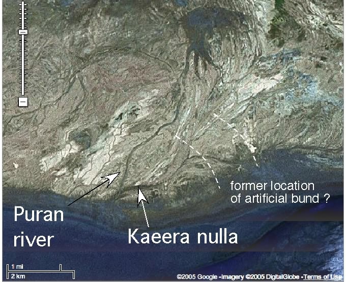
This
GoogleEarth image brackets a range of locations where Burnes observed an
artificial dam blocking the Kaera or Kaeera nulla from flooding the road to
Vigakot prior to the 1819 earthquake. It is possible the dam lay south of the
present northern shore of Lake Sindri. The channel Burnes sailed 2 miles up in
August 1828 trends ≈N for one mile but then veers NE for a further mile. Although he describes the channel as a
staight canal he omits mention of this bend.