Chronology of accounts related to the 16 June1819 earthquake in Kachchh (Allah Bund, Kachchh mainland and Sindh region).
Dates in bold indicate the rare site visits to the Allah Bund.
1808 Captain R. M. Grindlay sailed past Fort Sindri, made a sketch of it, and then headed north of the (apparently non-existent) Allah Bund. He noted that Fort Sindri was located on the sandy east bank of a 2 km wide stream across which a ferry plies. He noted nothing of interest north of Sindri (see discussion ) until he arrived at Aly Bunder, an artifical dam far north of the Allah Bund that separated the salt water to the south from the impounded freshwater to the north, and which he describes as being the northen limit of the Rann of Kachchh.
1809 Captain J. MacMurdo appointed British Resident with headquarters in the port of Mandvi. See Ghosh S. K (1976) for short biography of MacMurdo.
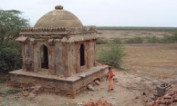
16 June 1819 Earthquake at 4 pm destroyed numerous masonry forts in Kachchh. The earthquake raised the bed of the Narra at a feature that became known as the Allah Bund 5 miles north of Fort Sindri (Allah Bund = the natural Dam of God, to distinguish it from Aly Bundar, the artifical dam of Aly). It also created a tsunami, and a depression that filled with salt water from the tsunami. Survivors perched on the one surviving ruined tower of Fort Sindri at the center of this lake were rescued by boat and carried southward to the Kachchh mainland. A submerged region of elevated Rann resembling the Allah Bund was formed north of Lackput near Sundo. Macmurdo and others wrote numerous reports to the Government in Bombay (eyewitness and news paper accounts transcribed from India Office records).
1820 (20 Jan) Macmurdo completed an article on the earthquake published first in the Literary Society of Bombay, and reprinted as "Papers relating to the earthquake in India in 1819". Philosophical Magazine and Journal, 63, 105-119 and 170-177, 1824. (download 1824 pdf ) . A summary article was printed in Vol. 3 (120-124) of the Edinburgh Philosphical Journal April-Oct, 1820 (download 1820 pdf.)
1820 (28 April) Macmurdo dies of cholera. (His tomb bears the inscription In Memoriam, Captain James Macmurdo, first British Political Resident in Cutch, Died of Cholera at Warnu, on 28th April 1820).
1825 Burnes appointed to Kachchh and (1825-8) makes map of Kachchh region 4"=1 mile as "an amusement". The map was completed in March/April 1827 and a simplified version of the map (Burnes' map of Kachchh ) is reproduced by Oldham (1926).
1826 November Flood on Indus overflows headwaters, bursts upstream dams, overtops the raised channel through the Bund and fills Lake Sindri with fresh water.
1827 March. Alexander Burnes first visit. He observed vertical banks 10' above river level, river 5 ' deep, width of channel 30 yards. See 1828 report.
1828 August. Alexander Burnes second visit: He now observes the channel "much enlarged". He writes his March 1827 & August 1828 observations in August at Lackput and uses parts of this ms for his later articles. This original (linked here with a hand-written introduction by R. D. Oldham written in 1924) is far more descriptive than his later summaries and contains important insights on the changes to Sundo, Sindri and the Allah Bund. He attached a simplified version of this report as an Appendix (pdf) to his 1832 Memoir Travels into Bockara, which is the account read by most investigators.
1829 June. The East India Company orders Lord William Bentick to open the Indus for trade. A large mission led by Pottinger is prepared to visit the Amirs of Sindh.
1831 December Lt. Edwarde DelHoste travels from Mandvi (21Dec 1831) to Hyderabad (26 Jan 1832) via Lakhpat (Jan 10 1832 outbound, and 11 May 1832 return) with the Pottinger mission. His report is precise and informative along the route throught the Indus delta. He confirms earthquake damage in Kachchh and relates his observations to Burnes' reports, confusing Aly Bandar with the Allah Bund neither of which are visited by the mission.
1834 Grant(1837 pdf) mapped the Kachchh mainland and viewed Fort Sindri from Lakhpat, 40 km to the south. Grant's account mentioned uplift at Sundo, and the overturn of precariously balanced rocks at Baboa Hill near Lackpat. [p. 311 Large blocks of shelly limestone composing the summit of the hill, are found scattered about its sides and base........some fell during the earthquake of 1819]. small map large map
1836 Lyell describes the 1819 earthquake using McMurdo's and Burnes' accounts.
1837 Carless(1838) makes the first accurate map of the Indus delta including Koree creek and Lakhpat but does not visit the Allah Bund or Lake Sindri. (see annotated extract and map)
1838 Grant, at Lyell's request, sends a surveyor to Fort Sindri and to the Allah Bund. Grant sends these data to Lyell but does not publish. Lyell published the plate of ruined Fort Sindri (which was later re-drafted and modified by de_Ballore 1924 published posthumously, along with a mislabelled version of Baker's leveling section across the Allah Bund)
1841 Burnes assassinated in Kabul
1844 25 June to 30 July Baker maps the slope of the river bank and bed from Lake Sindri to Mora Bund. For three days (8-10 July) he leveled from his starting point at the Mora Bund southward at 6 miles/day, but the remaining 19 miles from Aly Bunder to the Allah Bund and Lake Sindri was levelled in one day only, on 11 July 1844. He measured the surface near the Mora Bund and the crest of the Allah Bund both to be 20.5 feet above the level of Lake Sindri.
19 June 1845 Lackput Earthquake. Mrs Derinzy writes to Nelson about a mainshock/aftershock sequence (66 aftershocks) and tsunami near Lakhpat in 19-25 June 1845. A paragraph of this is published by the Geol. Soc of London in 1846 after which most people erroneously attribute the letter to Nelson 1845. (. pdf ) The earthquake is described also in Gentlemans Magazine but accounts of this earthquake are sparse.
1851 Le Grand Jacob marched from Mandvi to Lakhpat and described the 1845 earthquake sequence [but indicates its date erroneously as June 1844. Oldham (1926) identified this as an error in LeGrand Jacob's translation of the Jeth Samvat date. Also Baker makes no mention of a recent earthquake during his 25 June-30 July visit in 1844]. LeGrand Jacob mentions the destruction to the fort at Lakhpat in 1819 and 1845, and the 1819 destruction of the fort at Tera (50 km SE of Lakhpat).
1854 Raikes S. N., assistant political agent 1854 indicates height of Bund is 18 feet. Cited by Oldham (1926). Sel. Rec. Bombay Govt. Rep XV, New Series, 1855 p.46. Raikes compiled a summary of articles on Sindh (!!12 Mb pdf) which mentions the 1819 earthquake briefly. It is of interest because he states clearly that forts (eg Lakhpat) damaged by the 1819 earthquake were not reconstructed in 1819. ie the damage now visible at Lakhpat is the result of two earthquakes (1819 and 2001) and suggests Intensity VIII max.
1856 Surveyer Mr. Da Costa traveled by boat from Lakhpat to Sindri.(cited by Oldham, 1926)
1860 Frere visits the Rann of Kachchh (.html extract from his 1870 publication )
1866 Tremenheere (pdf 1867) writes account of river systems of the lower Indus.
1868 December Wynne (published 1872.pdf) sees copy of Baker's section. He fails to sail from Lakhpat to Sindri in December that year. A month later (January 1869) he walks/rides to Sindri from Nara (the village on the north shore of Kachchh), but apparently does not visit the Bund. See Wynne's pages discussing on Allah Bund.
1870 Frere publishes "Notes on the Rann of Cutch and Neighbouring Region" J. R. Geog. Soc 40,181-207 (1870) and "On the Runn of Cutch, and Neighbouring Region H. Bartle, E. Frere Proc. R. Geog. Soc. Lond., 14(2), pp. 120-124 (1869 - 1870). See .html extract.
1880-4 The Survey of India maps the Rann of Kachchh and Allah Bund. See .pdf of Allah Bund portion, and Kachchh portion.
1882 R.D. Oldham edits his father's notes on earthquakes in India (Oldham. T, 1882) and publishes it as a Memoir.
1898 Oldham (1898.pdf) finds copy of Baker's section in Bombay and publishes it, but erroneously reports the total relief in the text as 20 feet (28 years later, in 1926 he notes the error and states it as 30 feet). The copy Oldham found was probably that belonging to Wynne where he describes the crest of the Mora Bund and Allah Bund being identical and the ground starting about 4 miles north of the "Sindree depression, when it commences to rise to the Allah Bund, gaining there a height of about 19 feet".
1907 Sivewright(1907.pdf) describes Sindh and the possible origin of the Rann of Kachchh in a rambling report, in which he includes leveling in the Little Rann, very far from the Allah Bund. It includes hearsay information on river channels NE of Hyderabad that stopped flowing for several days after the 1819 earthquake "Cutch and the Ran", Robert Sivewright, Geographical Journal, Vol. 29, No. 5 (May, 1907), pp. 518-535 plus "Cutch and the Ran: Discussion" Admiral Field, J. W. Evans, R. D. Oldham, C. E. Yate, Athelstane Baines, Mr. Heawood, Dr. Owens, Mr. Sivewright. Geographical Journal, Vol. 29, No. 5 (May, 1907), pp. 535-539.
1910 Reid cites the Allah Bund earthquake as an example of elastic rebound.
1924 Montessus de Ballore (1924.pdf, posthumous) erroneously doubled the height of the Bund when redrafting Oldham''s version of Wynne's Copy of Baker's section. (see .html discussion)
1926 Oldham (1926.pdf) 44 years after first writing about the 1819 Allah Bund earthquake in his father's 1882 chronology of Indian earthquakes, and 28 years after finding Baker's map in 1898, Oldham published a definitive memoir summarizing most of the above. He is apparantly unaware of Reid's 1910 article.
1962 Platt(1962) discusses the formation of the Rann of Kachch and contains a summary of Oldham 1926 (with errors).
1964 Raikes, R. L. (1964) discusses the case for repeated flooding of the Indus as a cause for the end of the Harappan Civilization. Uses the Allah Bund as an example of river impoundment by earthquakes.
1998 Bilham (1998.html) uses Baker's 1846 data to calculate a mechanism for the 1819 event.
1999-2001 Rajendran and Rajendran(2001) visit the Allah Bund and find maximum relief of 5 m, and claim the Bund to have been formed in 3-4 events in the past 1-2ka years based on preserved terraces, and dated materials in trenches north of the Allah Bund.
2007 Team from Ahmedabad visits the Allah Bund and finds no terraces, but significant evidence for erosion-induced inverted topography. The Allah Bund is now characterized by subdued relief.