Indian Plate collision
Theory and observation confirm that the Indian Plate is moving towards Asia at 4-6 cm/yr, rotating slowly counterclockwise as it does so, and slowing in velocity as a result of penetration into Asia, and the rise of the Tibetan plateau. The collision rate along the Himalayan plate boundary, which is responsible for great Himalayan earthquakes, is approximately 16-20 mm/yr [5]. In contrast, deformation within India occurs at a rate that is almost imperceptible, but certainly less than 3 mm/yr [6].
Tectonic stress near Jaitapur
The seismic setting of the India's Arabian Sea coast is influenced by two major stress fields: a NNE/SSW flexural stress field of long wavelength resulting from India's collision with southern Tibet, and a potential energy field caused by the 4 km of vertical relief between the Arabian sea floor and the continental edge of India (Gaur and Bilham, 2012). The first is responsible for focusing shallow N/S compressive stresses at latitudes near Jaitapur, and the second for imposing E/W tensile stresses similar to those that accompanied the initial rifting of India from Gondwana 160 My BP. These stresses are complimentary along the western coast of India, changing imperceptibly with time.
Earthquakes in the subcontinent are infrequent. Bilham and Gaur (2012)highlight the brevity of historical seismic catalogs that consequently provide an unreliable guide to future seismicity. They suggest that the flexural setting of Jaitapur is such that earthquakes of similar magnitude to Latur (M6.3) or Koyna (M6.5) could occur nearby, should local faults of sufficient length to host moderate earthquakes exist. The Nuclear Power Corporation of India considers this unlikely.
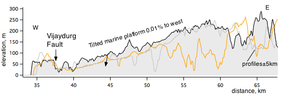
The Jaitapur coast consists of a raised and warped marine terrace, with significant fluvial dissection. The marine terrace has been offset more than 20 m by the Vijaydurg fault, prominent on SRTM imagery as a 35-km-long normal-fault, down to the east, with an unknown length offshore. Erosion of its east-facing fault scarp is immature indicating that slip has been relatively recent. Scaling laws associate a fault length of 35 km with M6.5 earthquakes.
If the visible fault scarp postdates emergence of the marine terrace which it has offset, and if the date of most recent emergence is 50,000 years, a slip rate of 0.5 mm/yr is indicated. If Mw>6.5 earthquakes on the fault result from slip of 1 m they would recur every 2000 years. No earthquake has occurred in the past 500 years.
The scientific question to be addressed is whether the Vijaydurg fault is truly inactive as is now assumed. The matter is discussed by Gaur and Bilham, 2012.
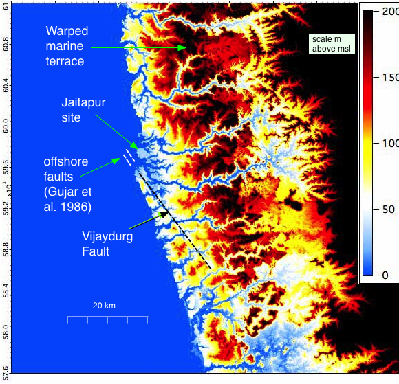
Submarine faults have been mapped offshore within 3 km of the proposed site by NIO, India's National Institute of Oceanography (Gujar et al., 1986) but it is not known how far north these extend. The absence of paleoseismic trenching of the Vijaydurg fault renders its current activity speculative.
Tsunami?
The 20 m elevation of the proposed Vijaydurg site renders it immune to modest tsunami from the Makran coast. A local tsunami source, however, should be considered (offshore faulting and sediment slumping). The proposed power plant lies on the hanging wall of the Vijaydurg fault, which would be lowered during a major earthquake, aggravating run-up, as occurred along the Tohoku coast in 2011.
A significant tsunami is recorded at dawn 11 Sept 1524 offshore Dabul some 100 km north of Jaitapur. The following is from Logan (1888).
"On 11th (or 21st) September 1524 Vasco da Gama as Viceroy of India arrived at Goa with 3000 men in 14 ships. On reaching land at Dabul and with the wind becalmed during the watch at daybreak, the sea trembled in such a manner, giving great buffets to the ships, that all thought they were on shoals, and struck sails, and lowered boats into the sea with great shouts, and cries and discharge of cannon. On sounding they found no bottom, and they cried to God for mercy because the ships pitched so violently that the men could not stand upright and the chests were sent from one end of the ship to the other. The trembling came, died away, and was renewed each time during the space of a Credo. The subterranean disturbance lasted about an hour, in which the water made a great boiling up, one sea struggling with another. When daylight was fully come, they saw the land."
See Bendick and Bilham, 1999 for a second account in which de Gama is alleged to have recognized the effects of an earthquake. "Buffeting" and "trembling" are typical of accounts of ships that sense seismic waves through the ship's hull. The hour long duration of these shocks is typical of a mainshock aftershock sequence, and the lurching and shifting of cargo amid disturbed seas are typical of a near-shore tsunami, but in this case the fleet appears to have been in deep water. Thus although the evidence seems to favor interpretation as a significant (M>7) local earthquake, it is possible that alternative explanations may exist (Zhang, 2003). although none have been discussed in the site investigations currently published (December 2012).