
Long baseline tiltmeters using horizontal water pipes up to 500 m long are operated in several locations: Pinion Flat Observatory, Long Valley California, Washington State, Pozzuoli Italy and in the Guerrera region of Mexico.
Slow Earthquakes in Washington State Three biaxial tiltmeters are currently recording surface deformation caused by slow slip events beneath Seattle. The tiltmeters consist of 300-500 m long buried water pipes with sensors that monitor the water level with a resolution of approximately 0.05 micron. View the data from these instruments at www.geodesy.org . Click on New Biaxial Tiltmeters in the Pacific Northwest . For data up to an hour ago click on "Monitoring of the 2008 ETS" . Note the scale is in nanoradians (0.001 microradian). The earth tide has an amplitude of approximately 100 nrad east west.
Long Valley California Long Valley tiltmeter data sampled at 10 minute intervals may be viewed at the USGS long Valley web page. Alternatively a backup data logging system is operated by CU; data with 15 minute samples are stored with a latency of up to 2 hours at DataGarrison (use the log in geo and the password hobo. ) The data are named from the vaults: West, Northeast and South and values are listed in microns. In 1998 a slow slip event occurred on the graben fault in the caldera floor. The proximity of this normal fault to the tiltmeter (see map) distorts the measured tidal tilt-field through strain-tilt coupling.
Pozzuoli Tiltmeters monitor inflation of the Phlegrean Fields in Naples. Data sampled at 15 minute intervals are stored at DataGarrison (use the log in geo and the password hobo. ) The data from the Northwest and Southeast sensor of a 91 m long tiltmeter can be dowloaded and differenced to determine tilt within 2 hours of acquisition. Data are listed in mm.
A tiltmeter measures rotation of the earth's surface relative to a horizontal datum defined by gravity. The renowned physicist, Michelson, noted in 1919 that the most favorable arrangement to obtain high sensitivity to tilt and to obtain immunity from temperature perturbations, is to use the equipotential surface defined by water in a buried half-filled water pipe.
Tilt of the Earth's surface causes the water in long baseline tiltmeter to flow to maintain an equipotential surface within the pipe. The equipotential datum has zero drift except where mass changes occur near the tiltmeter, as for example, may occur near the magma chamber of an active volcano.
Tilt is measured by monitoring the changing depth of water at each end of the water pipe using sensitive float transducers. Tilt is the difference in height divided by the length. In most water pipe tiltmeters the length is ≈500 m, and tilts can be measured to an accuracy of better than 1 µm. Hence tilts smaller than1 nanoradian (1 nrad) can be measured (equivalent to detecting a height change of a tenth of an inch between San Francisco relative to New York). The electronic range of the water level sensors is typically ±20 mm providing a tilt measurement range of 80 microradians (µrad). The picture below shows the new float sensors on a test bed. Each sensor uses a glass/gold-plated float with one degree of vertical freedom. The water level is sampled 5 times a second and digitally filtered to 64s before transmission once per minute to a central computer via a 16 bit radio modem link.
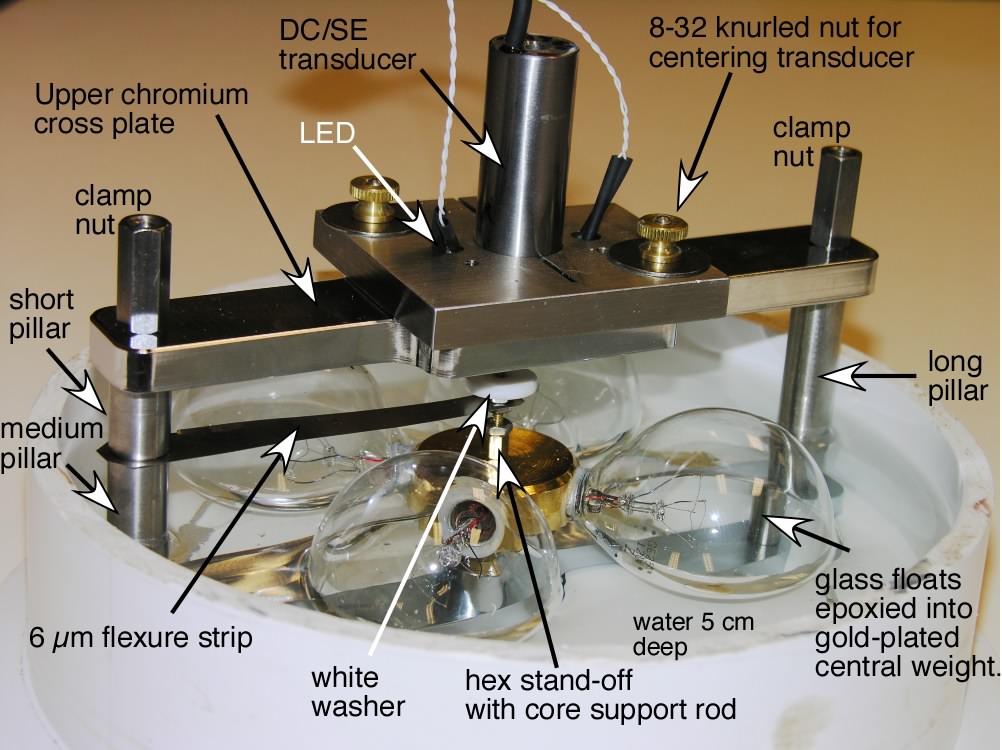
Other designs for tiltmeters have been devised from time to time but none are immune to thermal signals as the configuration devised by Michelson. Uniform temperature changes do not effect the tilt signal because they raise or lower the water level equally at each end. Moreover, local variations in temperature result in convection in the water that do not perturb the measurement points at each end. The temperature of each transducer is measured precisely to correct the observations for secondary effects. The pipe is sealed and is therefore immune to pressure fluctuations in the atmosphere. Slow leaks in the air or water paths have no effect on the tilt signal. The pipe is buried at 1.5-2.5 m depth.
To reduce sensitivity to surface effects like rainfall, snow loading and soil expansion or contraction, the measurement of water height is made relative to the upper surface of a deep, stable monuments. These consist of helical piles - rigid steel tubes with a single- or multiple-turn helical vane at their base, driven 20-30 m into the subsurface. Helical piles were designed initially to support the multi-ton loads of bridges spanning wide rivers. They are now used routinely to stabilize house foundations and hillsides.
The two design disadvantages of the Michelson tiltmeter are that the pipe must be installed approximately horizontal, and the fundamental resonant frequency in the pipe is 20-25 minutes (PVC pipes of 15-20 cm diameter are commonly used). The resonance period is close to critically damped in a 15 cm pipe, but Michelson tiltmeters are unable to detect short period horizontal accelerations, or tilts at seismic periods.
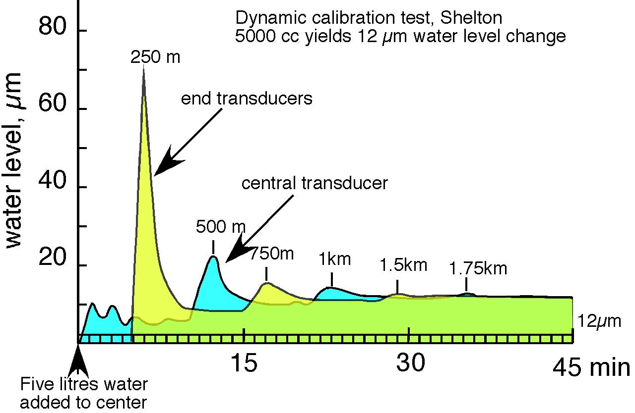
Several methods of calibration are possible. The transducers are calibrated prior to installation, but their relative calibration can be tested by adding a volume of water at the center of the pipe and measuring the eventual change in water level. It takes approximately 35 minutes for tsunami-like oscillations to cease and for the new water level to be established. The fundamental resonant mode is 24 minutes. 5 litres of water produces a 12 µm increase in water depth.
Initial results from the Shelton tiltmeter can be downloaded as a Keynote talk presented at the Fall American Geophysical Union Meeting in 2005.