Sierra Nevada EarthScope Project (SNEP)
An NSF research highlight!
The REPORT
OF THE ADVISORY COMMITTEE FOR GPRA PERFORMANCE ASSESSMENT FY 2007 highlighted
SNEP as the significant earth science highlight in the NSF's goal of improving
research infrastructure: "Imaging
of a Foundering Lithosphere (0454524; 0454535; 0454554) Drs. Hersh Gilbert
of Purdue University, Craig Jones of University of Colorado, Tom Owens of University
of South Carolina, and George Zandt of University of Arizona analyzed NSF's
EarthScope seismic data to identify a region where the mantle lithosphere is
currently being stripped from beneath the Sierra Nevada batholith. As our understanding
of processes related to the removal of mantle lithosphere improves, the important
role played by lithospheric removal in continental deformation becomes increasingly
apparent. Along the central portion of the western foothills of the Sierra,
small earthquakes occur deep within the crust. These events may result from
stresses associated with the lithospheric removal process. Resolution of EarthScope
data has allowed a significant advance in understanding of the tectonics of
mountain building and plate interactions. "
Who:
above is list of PIs/co-Is (in bold) and their postdocs and students. SNEP
participants are also working with the Sierran
Drips CD Project. We have also had help in the field and lab from IRIS
interns Amanda Thomas and Scott Burdick (whose
primary work was SNEP) and Christina
Viviano and Monica Guerra (whose primary work was
elsewhere) in 2005 and Will
Levandowski (2006; he joined up with CU in 2008) , USC undergraduates Katrina
Byerly, Nickles Badger, and
Will Huff , CU graduate students Joya Tétreault,
Gaspar Monsalve, Tom de la Torre, Chris
Harig, USC
staffers Charlie Groves,
Philip Crotwell, U of A graduate students Andy
Frassetto,
Josh Calkins, Arda Ozacar ,
and CU volunteer Kristen Marano. Derry
Webb from PIC helped in the field and
many others at PASSCAL also
have helped. (I think that is 26 people who have been in the field under the
SNEP banner....)
SNEP mailserv is
at South Carolina (along with list archives).
What, When, and Where:
~48 broadband seismometers were deployed from spring 2005 to September
2007 from about Kings Canyon National Park north to Honey Lake and west
from the Central Valley into the Great Basin.
Analysis responsibilities are distributed with certain institutions taking
the lead on different approaches:
| Ambient noise tomography |
Univ. South Carolina |
| Body wave tomography |
Univ. Colorado, Boulder |
| Bulk crust from receiver functions |
Univ. South Carolina |
| Crustal receiver function anisotropy |
Univ. Arizona |
| Deep local earthquakes |
Purdue Univ. |
| Receiver function CCP imaging |
Purdue/Univ. Arizona |
| Regional waveforms |
Univ. South Carolina |
| SKS/S-wave splitting |
Univ. South Carolina |
| Sp receiver functions |
Univ. South Carolina |
| Teleseismic attenuation |
Univ. Colorado, Boulder |
| Teleseismic surface waves |
Purdue Univ. |
Known problems, Phase I: (removal): 53, GPS removed by bear, 62 whole packer pulled by bear. (July service): 75 panel crushed; 65 GPS rare lock after 3/06, 14 GPS failed 1/2/06. (June '06 service): 64 was down much of winter, 55 sensor was
way out of center, both noisy on horizontals??, 45, 46 and 56 down significant
time (45 panel lost), 56 panel was partially loose, 86, 24 heavily damaged,
43 lost parameters and int batt dead, 23 battery dead (green box failure?),
63 junky sensor and flooded, 23 bad green box. (May '06 service) 52, 74, 22, 12,
84, 95, 67, 66, 57, 47, 36 all had problems at some level. flooded sites were
12, 52, 53, 95; others GPS and/or power problems. (over winter) 34 disk filled;
(Jan) 42 stolen (replaced); 11 flooded (moved). 51,52,71 had leveling problems
during high rain. Some east side GPS problems; (Oct '05) 74 opened by bear (lost
power but recovered OK when reconnected); 21 has high frequency noise (no obvious
solution), seems to have tilting problems (repeatedly loses horizontals), 22 had 6 second (?) timing error; repaired 8/3/05, 64 might need extra panel.
Phase
II problems: Pullout, September 2007: 65-GPS died 07.056 (vault flooded and DAS died 07.133; sensor pins corroded) 87-GPS dead after 07.187 A8-Ch 3 dead 07.142, DAS stops dumping 07.178 B5-sensor or A/D noise after 07.176 C6-vault uncovered, noise on horizontals C8- GPS died after 24 hours and station down at 07.151 G5-Ch 1 dead after 07.246 May 2007: 12-powered
down, short in sensor cable, 24-dead after one dump 55-plug
pulled 87-GPS
died 06.283 97-disk full 98-minor power outage
towards end? A7-GPS out for 53 days B5-power
system down after 07.068 B6-coherent noise on horizontals B7:
power system failures after JD 94. E7-outages JD 30-60. January
2007: F9, very low sunlight, hole in DAS vault
lid-now two panels and batteries, new lid; D4, D5, C4, E5, E4 frequent
tilt-out of horizontals (autocentering frequency improved). GPS at E6 appeared
to be misbehaving-replaced. Bear damaged B5 (repaired). C3 flooded;
moved to shed above ground. 12 had no power--pin sleeve in
solar panel cable was pushed back into connector. E7 was in
the dark; panel moved 60' farther north. Disk problems from Jan. run disks
from G9, E9. Power outages noted 96, E5,
E4, E7, A4, F9 (more minor outages elsewhere). Stations we
didn't try to visit (19): G7, F8, C8, C6, B6, A5, 87, 86, 85, 75,
65, 64, 55, 34, 24, 14, 84, 74, and 63. So 33 of our 52 stations were visited.
Other maps
Map of SPE and SNEP2005 deployments on geologic base, with ES stations as
of April 2006 (click for pdf version):

Map of all Sierran portable passive deployments, 1988-2007, and US Array stations:
(click for larger version) (need to adjust for final SNEP deployment)

Why:
To better understand the physics of removal of mantle lithosphere and the
consequences of such tectonism.
Meetings:
- Seismology planning meeting, Tucson, late January, 2005
- Sierran Drips workshop, October 20-22, 2005, Park City, UT
- IRIS
Workshop, Jun 8-10, 2006.
- Joint SNEP/Sierra Drips CD meeting, Sorensen's
Resort, Hope Valley, CA, October 8-10, 2006.
- SNEP special session at 2007 Fall AGU (session
T31 : Foundering Lithosphere: Observations and Implications, with a Focus
on the Sierra Nevada)
- Fall meeting with Sierra Drips CD, Tucson, Arizona, 2-4 November 2008.
- Final workshop for Sierra Drips, Boulder, Colorado 8-10 November 2009.
Proposal documents:
The
2004 Earthscope proposal
Animation of Sierran uplift histories (a figure from Jones et al)--shockwave.
Fieldwork:
Field materials now on an archive page
Photo websites:
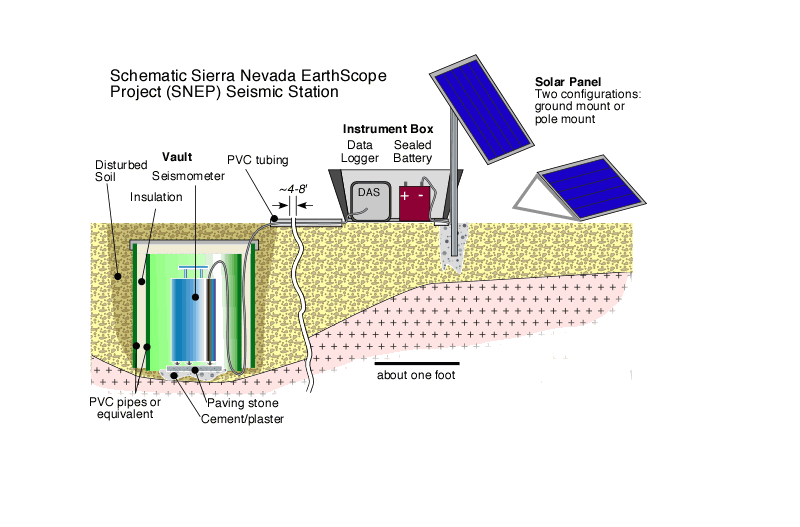
Cartoon of installation
| Date |
Event |
| December 2007 |
AGU meeting, San Francisco |
| November 2-4, 2008 |
workshop with Sierran Drips CD project members, Tucson |
| Fall, 2009 |
workshop with Sierran Drips CD Project, Boulder, Colorado |
| December 2010 |
Deadline for papers to special issue of Geosphere. |
Resources:
Maps:
GMT files: (and a simple
script to build a station map)
- SNEP evenly spaced (45 sites)
- SNEP plus Bigfoot in area
- US Array stations (from website, as lon, lat, ID)
- Trinet (CIT/SCEC) stations (so. CA) (lon, lat, station ID, station text, elevation)
- Trinet stations with BHZ channel (almost same as above) (so. CA)
- UNR broadbands reporting to IRIS (lon, lat, ID) (Nevada, eastern CA)
- UC Berkeley broadbands (lon, lat, elev, id, network id, station text, channels,
on year, on JD, on time, off year, off JD, off time)
Publications:
- Jones, C. H., Reeg, H., G. Zandt, H. Gilbert, T. J. Owens, J. Stachnik, P-wave tomography of potential convective downwellings and their source regions, Sierra Nevada, California, Geosphere, 10 (3), doi:10.1130/GES00961.1, 2014
- Levandowski, W., C. H. Jones, H. Reeg, A. Frassetto, H. Gilbert, G. Zandt, and T. J. Owens, Seismological estimates of means of isostatic support of the Sierra Nevada, Geosphere, 9(6), 1552-1561, doi: 10.1130/GES00905.1, 2013.
- Gilbert, H., Y. Yang, D. W. Forsyth, C.H. Jones, T.J. Owens, G. Zandt, and J.C. Stachnik, Imaging lithospheric foundering in the structure of the Sierra Nevada, Geosphere, 8, p. 1310-1330, doi:10.1130/GES00790.1, 2012.
- Frassetto,
A., G. Zandt, H. Gilbert, T.J. Owens, and C. Jones, Lithospheric Structure
of the Sierra Nevada from Receiver Functions and Implications for Lithospheric
Foundering, Geosphere, vol. 7 (4) pp. 898-921, doi: 10.1130/GES00570.1, 2011. (DOI not working; Geoscienceworld link)
- Frassetto, A., G. Zandt, H. Gilbert, T.J. Owens,
and C. Jones, Improved Imaging with Phase-Weighted Common Conversion Point
Stacks of Receiver Functions, Geophysical Journal International,
doi: 10.1111/j.1365-246X.2010.04617.x, 2010.
- Gilbert,
H., C. Jones, T. J. Owens, G. Zandt, Imaging Sierra Nevada lithospheric
sinking, EOS, 88 (21), pp. 225 & 229, 22 May, 2007.
- Jones, C. H., H. Gilbert, G. Zandt, T. Owens, The Sierra Nevada EarthScope Project: A first report from the broadband FlexArray, IRIS Newsletter, 2006 volume, issue 3, pp. 12-14. (small or large pdf version of full newsletter from IRIS)
In process:
S-wave paper, local earthquake paper (both hopefully showing up in 2019).
Theses:
- Levandowski, W., Geophysical investigations of the origins and effects of density variations in the crust and upper mantle beneath the western and central United States, 2014
- Reeg, H., Seismic structure of the crust and upper mantle of the Sierra
Nevada, California, M.S. thesis, Univ. Colorado, 139 pp., 2008
- Frassetto,
A., Teleseismic studies of the North American Cordillera: Evaluating the
changing structure, composition, and fabric after subduction, Ph. D. thesis,
Univ. Arizona, 2009 (info link)
Abstracts:
AGU, San Francisco, Dec. 15-19 2008--see list of presentations of potential
interest to SNEP
- Frassetto,
A., H. Gilbert, G. Zandt, T. J. Owens, and C. Jones, Seismic character
of the crust and upper mantle beneath the Sierra Nevada, Eos
Trans. AGU, 89(53), Fall Meet. Suppl., Abstract S32B-05, 11:20
am
- H.
Reeg., C. H. Jones, H. Gilbert, T. J. Owens, and G. Zandt, Tomographic
observations connecting convective downwellings with lithospheric source
regions, Sierra Nevada, California, Eos
Trans. AGU, 89(53), Fall Meet. Suppl., Abstract S32B-06.11:35
am
- T.
J. Owens, I. D. Bastow, N. Badger, G. Zandt, C. Jones, and H. Gilbert,
Shear wave anisotropy beneath the Sierra Nevada: Implications for lithospheric
foundering and mantle flow, Eos
Trans. AGU, 89(53), Fall Meet. Suppl., Abstract S33B-1956
,
PM poster
- Ryan,
J. C., A. Frassetto, O. Hurd, G. Zandt, H. Gilbert, T. Owens, and C. Jones,
Focal Mechanisms for Deep Crustal Earthquakes in the Central Foothills
and Near Yosemite National Park in the Sierra Nevada, California, Eos
Trans. AGU, 89(53), Fall Meet. Suppl., Abstract S33B-1957,
PM poster
- Levandowski,
W., H. Reeg, C. H. Jones, G. Zandt, T. J. Owens, and H. Gilbert, Constraints
on lithology of downwelling lithosphere from the Sierra Nevada, California, Eos
Trans. AGU, 89(53), Fall Meet. Suppl., Abstract U51B-0044,
AM poster
- Gilbert,
H., Y. Yang, D. W. Forsyth, C. H. Jones, T. J. Owens, and G. Zandt, Bounds
of foundering in the southern Sierra Nevada, Eos
Trans. AGU, 89(53), Fall Meet. Suppl., Abstract U54A-04,
4:45
pm
GSA, Houston, October 2008
- Zandt,
G., H. Gilbert, C. Jones, and T. J. Owens, Insights on Lithospheric Delamination
from the Sierra Nevada Earthscope Project (SNEP), Geol. Soc. Am
Abstr. Prog., 40 (6), p. 396, abstract 263-7, 2008.
IGC, Oslo, August, 2008
AGU, San Francisco, Dec. 2007
-
Badger, N. B., I. D. Bastow, T. J. Owens, G. Zandt, C. H. Jones, and H. Gilbert, Shear wave anisotropy beneath the Sierra Nevada range: Implications for lithospheric foundering and upper mantle flow, Eos Trans. AGU, 88 (52), Fall Mtg. Suppl., Abstract T33A-1149, 2007.
-
Reeg, H., C. H. Jones, H. Gilbert, T. Owens and G. Zandt,Teleseismic Travel-Time Tomography of the Sierra Nevada and its Foundering Lithosphere, Eos Trans. AGU, 88 (52), Fall Mtg. Suppl., Abstract T33A-1150, 2007.
-
Zandt, G., H. Gilbert, A. Frassetto, T. Owens, and C. Jones, Insights on Lithospheric Foundering from the Sierra Nevada Earthscope Project (SNEP) , Eos Trans. AGU, 88 (52), Fall Mtg. Suppl., Abstract T31E-01, 2007.
AGU, Acapulco, 22-25 May 2007
AGU, 11-15 December 2006
- Byerly, K., T. J. Owens, H. Crotwell, J. Julia,
H. Gilbert, G. Zandt, C.
H. Jones, Bulk crustal properties of the Sierra Nevada, Eos
Trans. AGU, 87(52), Fall Meet. Suppl., Abstract S43A-1358,
2006.
- Bastow, I. D., T. J. Owens, G. Zandt, C. Jones, H.
Gilbert, J. Julia, SKS splitting analyses from the Sierra Nevada Earthscope
Project: Insights into lithospheric foundering, Eos Trans. AGU, 87(52),
Fall Meet. Suppl., Abstract S43A-1361, 2006.
- Gilbert, H., C. Jones,
T. Owens, G. Zandt, Observations of lithospheric foundering, Eos Trans.
AGU, 87(52), Fall
Meet. Suppl., Abstract S54A-01, 2006.
- Frassetto, A., I. D. Bastow, O. Hurd,
G. Zandt, H. J. Gilbert, T. J. Owens, and C. H. Jones,
Crustal anisotropy, deep crustal earthquakes, and the Moho hole beneath
the west-central Sierra Nevada, California, Eos
Trans. AGU, 87(52), Fall Meet. Suppl., Abstract T52B-02,
2006.
- Hurd, O., A. Frassetto, G. Zandt, H. Gilbert, C. Jones,
and T. J. Owens, Deep Crustal Earthquakes and Repeating Earthquakes in
the West-Central Sierra Nevada, Western USA, Eos Trans. AGU, 87(52),
Fall Meet. Suppl., Abstract S43A-1360, 2006.
- Levandowski, W., C. H. Jones, Receiver functions from medium aperture
broadband beams and the Moho of the Sierra Nevada, California, Eos
Trans. AGU, 87(52), Fall Meet. Suppl., Abstract S54A-03,
2006 (won best student presentation, seismology section)
IRIS Meeting, June 8-10, 2006, Tucson, AZ
- Zandt, G., "Southern Sierras", 2:05-2:25 June 8. Powerpoint is
here and note there
are 2 movies needed as well in the same directory.
- US Array posters 10:30 am - 12:00 noon
AGU, 5-9 December 2005
- Burdick,
S., Zandt, G., Gilbert, H., Jones, C., Owens, T (2005) Moho Structure of
the Central Sierra Nevada From an EarthScope Flex Array Deployment, Eos
Trans. AGU, 86(52), Fall Meet. Suppl., Abstract S41E-05 .
- Byerly,
K., Julia, J., Owens, T J., Gilbert, H., Zandt, G., Jones, C. (2005) Sierra
Nevada Earthscope Project: Constraints on the Sierran Seismic Structure
From Regional Waveform Modelling, Eos Trans. AGU, 86(52),
Fall Meet. Suppl., Abstract S51E-1062
- Gilbert,
H, Hurd, O, Jones, C H, Owens, T J, Zandt, G (2005) Observations of deep
intra-plate earthquakes along the western foothills of the Sierra Nevada, Eos
Trans. AGU, 86(52), Fall Meet. Suppl., Abstract S51E-1067.
- Thomas,
A, Jones, C, Reeg, H, Gilbert, H, Zandt, G, Owens, T (2005) Teleseismic
travel times, the Isabella anomaly, and the missing Moho, from the Sierra
Nevada EarthScope experiment, Eos Trans. AGU, 86(52), Fall
Meet. Suppl., Abstract S51E-1061
GSA, October 2005
- Jones,
Craig H, G. Zandt, T. J. Owens Jr., and H. Gilbert, The Sierra Nevada Earthscope
project: Motiviations, status, and early results, Geological
Society of America Abstracts with Programs, 37 (7), 59,
2005.
IRIS Meeting, 19-21 June 2003, Fish Camp, CA: (click for abstract)
- Mihai N. Ducea, Jason Saleeby, Crustal production and loss in continental
magmatic arcs; Evidence from the Sierra Nevada (talk, 4:30 Saturday, Salon V
and VI)
- Craig
H. Jones, G. Lang Farmer, Peter Molnar, Jeffrey R. Unruh, Delamination
of the Sierra Nevada: Seismological observations and tectonic implications (poster)
[pdf version of poster online,
2.3 Mb, click here]
- George
Zandt, Hersh Gilbert, Thomas J. Owens, Drip Drag? (poster)
Reprints/Preprints of interest:
-
Boyd,
O., C. H. Jones, A. F. Sheehan, Foundering
lithosphere imaged beneath the southern Sierra Nevada, California,
USA, Science, 305,
660-662, 2004. (Supplementary
material)
- M. N. Ducea,
Constraints on the bulk composition and root foundering rates of continental
arcs: A California arc perspective, J. Geophys. Res., 107 [B11],
2304, doi:10.1029/2001JB000643, 2002
- M.N. Ducea,
S. Kidder, G. Zandt, Arc composition at mid-crustal depths: Insights from
the Coast Ridge Belt, Santa Lucia Mountains, California, Geophys.
Res. Letts., 30 [13], 1703, doi: 10.1029/2002GL016297,
2003.
- Jones,
C. H., G. L. Farmer, and J. R. Unruh, Tectonics of Pliocene removal of
lithosphere of the Sierra Nevada, California, Geol. Soc. Am. Bull., 116 (11/12),
1408-1422, 2004.
- Molnar,
P. H., and C. H. Jones , A test of laboratory based rheological parameters
of olivine from an analysis of late Cenozoic convective removal of mantle
lithosphere beneath the Sierra Nevada, California, USA, Geophysical
Journal International , doi: 10.1111/j.1365-246X.2004.02138, 156 ,
555-564, 2004.
- S. K. Park
and M. N. Ducea, Can in situ measurements of mantle electrical conductivity
be used to infer properties of partial melts? J. Geophys. Res., 108 [B5],
2270, doi:10.1029/2002JB001899, 2003
- S. K.
Park, and B. P. Wernicke, Electrical conductivity images of Quaternary
faults and Tertiary detachments in the California Basin and Range, Tectonics, 22 [4],
1030 10.1029/2001TC001324, 2003.
- S. K. Park, Mantle heterogeneity beneath eastern California from magnetotelluric
measurements, J. Geophys. Res., 109, B09406, doi:10.1029/2003JB002948,
2004.
- J. Saleeby,M.
Ducea, D. Clemens-Knott, Production and loss of high-density batholithic
root - southern Sierra Nevada, California, Tectonics, 22
[6], 1064, doi:10.1029/2002TC001374, 2003.
- J. Saleeby
and Z. Foster, Topographic Response to Mantle Lithosphere Removal in the
Southern Sierra Nevada Region, California, Geology, 32 [3],
p. 245–248;
doi: 10.1130/G19958.1, 2004.
- G.
M. Stock, R. S. Anderson, and Robert C. Finkel, Pace of landscape evolution
in the Sierra Nevada, California,
revealed by cosmogenic dating of cave sediments. Geology,
32, [3], p. 193–196; doi: 10.1130/G20197.1, 2004.
- G. Zandt, The
Southern Sierra Nevada Drip and the Mantle Wind Direction Beneath the Southwestern
United States, International Geology Review (Thompson
Volume),45, 213-224, 2003.
- Zandt.
G., H. Gilbert, T. J. Owens, M. Ducea, J. Saleeby, and C. H. Jones, Active
foundering of a continental arc root beneath the southern Sierra Nevada,
California, Nature, 431, 41-46, 2004. (Supplementary
material)
Some other info on Sierran Paradox experiment webpage
This material is based upon work supported by
the National Science Foundation under Grants Nos. 0454535, 0454524, and 0454554
to CU, USC, and U of A, respectively. Any opinions, findings, and conclusions
or recommendations expressed in this material are those of the author(s) and
do not necessarily reflect the views of the National Science Foundation.
Please send mail to cjones@colorado.edu if you encounter any problems or have suggestions.
C. H. Jones | CIRES | Dept. of Geological Sciences | Univ. of Colorado at Boulder
