What is Salt Tectonics?
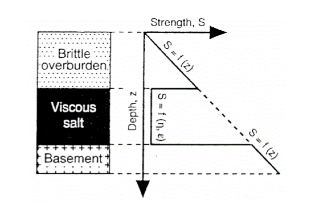
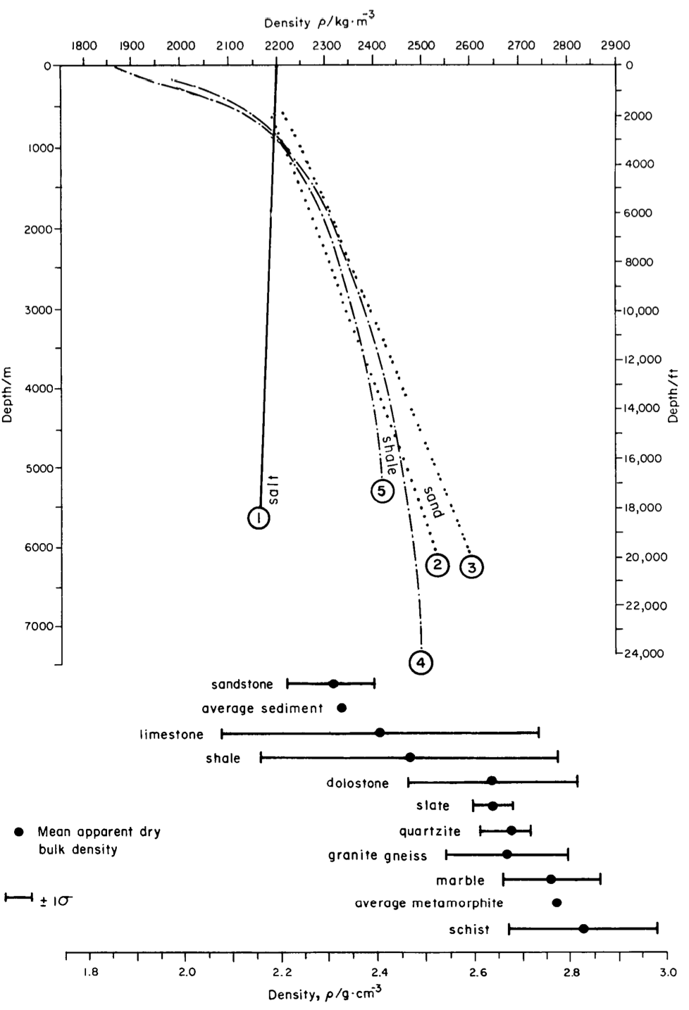
Salt is a sedimentary rock with unique properties different from most clastic and carbonate rocks, which forms unique structural and geomorphic features. Two important properties to recognize are: (1) Salt is weak and flows under geologic strain rates and has a low viscosity even at shallow depths (Fig. 1, Davison et al., 1996). This means salt will only break under unusually high strain rates (e.g. dike intrusion and mining), and under other conditions it will flow. (2) Salt is nearly incompressible, meaning it does not change density with depth. This makes salt less dense than sedimentary rocks at depth of 1660-3000 m (Fig. 2, Baldwin and Butler, 1985).
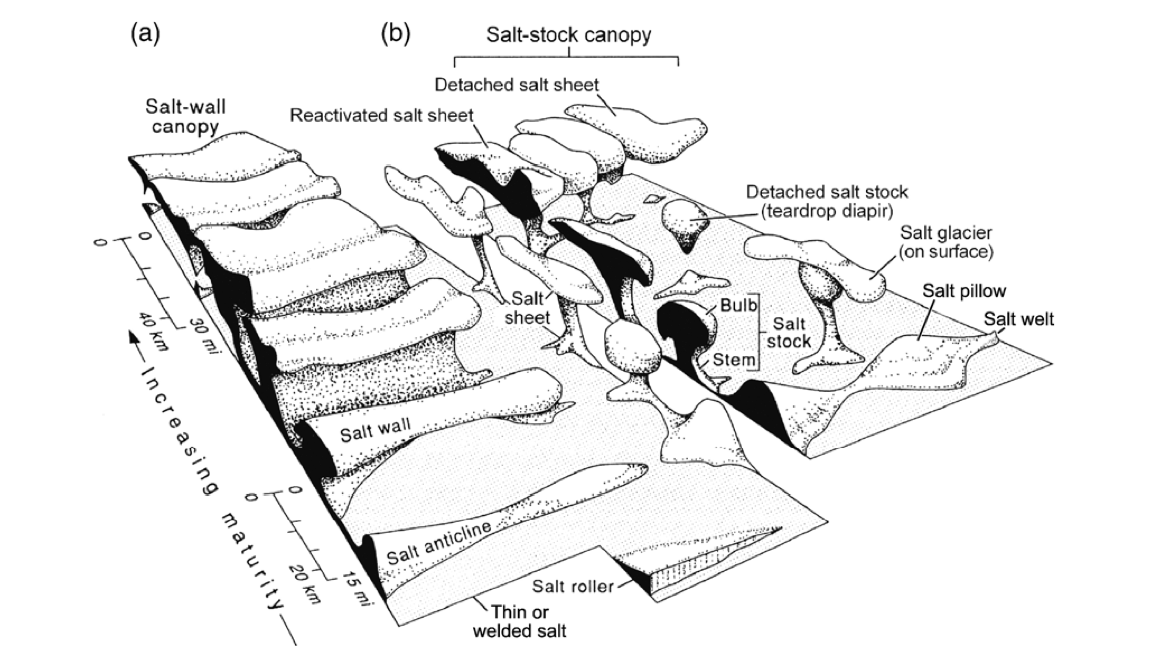
These properties of evaporite deposits create a unique set of structures that differ from structures formed in the absence of salt because salt flows at shallow depths. These features include salt pillows, anticlines, walls and diapirs (Fig. 3). Salt flow is initiated by external forces—differential loading— not buoyancy of the salt layer. Differential loading can include, but is not limited too, variations in sediment thickness, tilting of the salt layer, external extension or compression, and thermal expansion (Hudec & Jackson, 2007). Buoyancy of the salt layer is important in continuing growth of salt structures, not initiation of them (Jackson & Talbot, 1986).
Evaporite Basins in Western U.S.
Salt basins in the Western U.S. were formed in the Late Pennsylvanian to Early Permian due to uplift of the Ancestral Rockies. The load of these ancient mountain ranges formed flexural basins that were initially filled with a ~2500 m thick evaporite sequence and subsequently buried by clastic sediments. The evaporite sequence, Paradox Formation, was deposited due to fluctuating glacio-eustatic sea levels, creating a thick evaporite sequence with interbedded clastic deposits. Salt basins are located southwest of the Uncompahgre and Ancestral Front Range uplifts in the Paradox and Eagle Valley basins in eastern Utah and western Colorado.
Salt structures in these evaporite basins are formed by (1) differential loading during uplift and erosion of the Ancestral Rockies, (2)differential unloading due to fluvial incision, and (3) salt dissolution. Two good examples of these structures are on either margin of Paradox Basin. Collapsed salt walls on the eastern margin are represented on the surface as long valleys with cross cutting rivers, as opposed to rivers that typically flowing along the valley. Erosion of the Ancestral Rockies deposited clastic material on top of the evaporite layer, this caused salt to flow southwest, away from the source of sediment. The flow of salt created salt walls that are 2700-4500 m thick whose location is controlled by normal faults beneath the evaporite deposits (Trudgill, 2011). These salt walls subsequently collapsed due to groundwater dissolution, forming salt valleys across the northeastern Paradox Valley. See figures 12-14 in Interpretation for reference. The Needles District, on the western margin of Paradox Basin, is a series of extensional faults driven by incision of the Colorado River. As the Colorado River incised toward the Paradox Formation, salt began to flow northwest toward the river. This salt deformation led to brittle failure of the overlying sedimentary sequence, creating and array of extensional faults (Baker, 1933; Mcgill & Stromquist, 1979; Moore & Schultz, 1999). See figure 16 in Interpretation for a map.