The tectonic initiation of the San Andreas transform system
Introduction
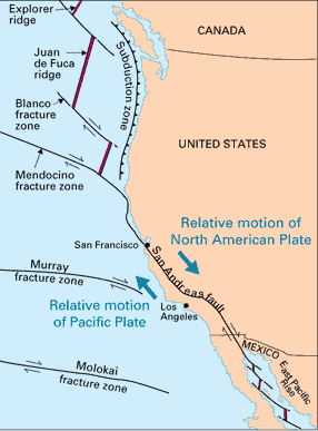
The San Andreas strike slip zone now dominates much of coastal California ( Fig 1 ) but this was not the case 30 Ma when North America was bordered on its west side by the subducting Farallon plate.
Fig 1 — Shows the present day plate boundaries and the familiar right lateral San Andreas. Taken from the USGS webpage.
This web site will explain the current views of how plate tectonics has unlocked the secrets of the past and allowed us to explain the initiation and development of the San Andreas.
This initial page will explain the basic concepts behind plate tectonics and paleomagnetics and show a simplified timeline of events. Readers can find more detailed information in subsequent pages which concentrate on slab gaps and the deformation caused within the continental US due to forces without.
Plate tectonics and Paleomagnetism
The theory of plate tectonics concerning the movement of rigid lithospheric plates above an essentially liquid asthenosphere revolutionized how people constructed geological histories. One of the best pieces of evidence for this was the discovery of magnetic reversal stripes found symmetrically about spreading centers at mid ocean ridges ( Vine and Matthews, 1963 ; Vine, 1966 ). An idealized model of this is shown in figure 2 with the main concept being that as asthenosphere rises at the mid ocean ridges it cools and acquires the magnetic field of the day.
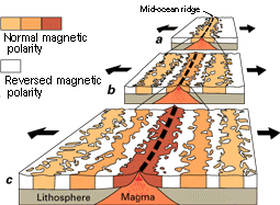
Fig 2 - A theoretical model of the formation of magnetic striping. New oceanic crust forming continuously at the crest of the mid-ocean ridge cools and becomes increasingly older as it moves away from the ridge crest with seafloor spreading : a. the spreading ridge about 5 million years ago; b. about 2 to 3 million years ago; and c.present-day. Taken from the USGS webpage.
Since the earth’s magnetic field switches poles every half million years on average ( the switch itself happens very quickly ; from 100’s-1000’s yrs ), cooled basaltic rocks that spread away from the ridges take on a striped appearance alternating between normal and reversed magnetic polarities
Since their interpretation, much work has been carried out to accurately map the sea floor magnetic anomalies and to date the transition times between normal and reversed events. Each period has been labeled with a chron number ( Chron 1 being the present ) and it is common practice within the literature to refer to a certain time period by its chron value.
What does all this mean for the San Andreas development. Well, with this information it is possible to deduce both the pole of rotation for a given plate ( plates on a spherical object such as the Earth move about an Euler pole which can be found directly from transform faults ) and the speed at which it is moving.
The next problem to be faced is how to establish a frame of reference as all the plates are moving relative to one another. One way is the global circuit reconstruction method. If the plate motions between North America and the Farallon plate were wanted it is possible to hold North America fixed and work out the plate vectors between ; North America and Africa, Africa and Antarctica, Antarctica and the Pacific and the Pacific and the Farallon plate. This would eventually lead to the Farallon motion relative to the stationary North America which is what we wanted. This may appear long winded but it is surprisingly accurate especially as better sea floor data is interpreted.
However, as the uncertainties are additive as each plate motion is calculated ( across spreading centers ), alternative frames of reference have been sought. An absolute frame of reference is one which is constant through time relative to the Earth, the most famous of which are hot spots ( Hawaii, Iceland, Yellowstone ). These mantle plumes leave expressions on the plate surfaces as the plates pass over them which leads to plate reconstructions by realigning old volcanic seamounts with the present day hot spot position. The best example of this is the Hawaiian/Emperor chain in the present day Pacific. Unfortunately recent data suggests that hotspots are not stationary relative to the Earth, nor to each other so the majority of plate reconstructions are based on global circuit models such as Nuvel-1A ( DeMets et al, 1994 ). Hot spot models are needed though for times before early/middle Jurassic as this is the oldest known sea floor available for plate reconstructions ( due to subduction at the oceanic margins ).
Figure 3 shows a magnetic chron map of the East Pacific from Severinghaus and Atwater (1990) with additional transform boundary information.
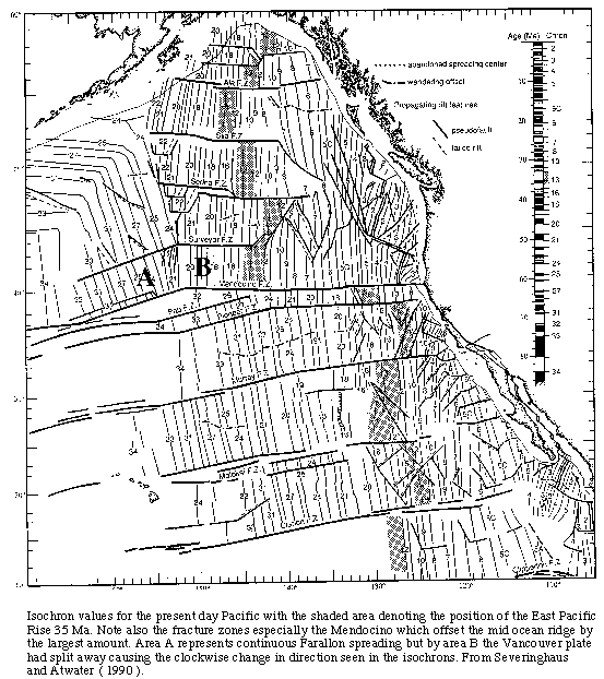
Notice near the Californian coast there are only chron numbers of 5 and higher while to the north ( Oregon, Washington ) and to the south ( Gulf of California ) there are chron numbers decreasing from the coast showing active rifting still taking place.
The main reason for calculating complicated global plate circuits is because a large part of the story behind the San Andreas development would be found in the motion of the now mostly subducted Farallon plate. Global circuit methods are a way of retrieving that lost information.
Tectonic timeline
We now have the tools to reconstruct the past, so how did it look. One of the first and perhaps best known tectonic evolution history of the Pacific and western North America is Atwater (1970) which utilized the juvenile plate tectonic theory to explain the San Andreas system and much more besides. This was updated and expanded in Atwater (1989) and most recently, Atwater and Stock (1998). There are many ( and I mean many ) more papers concerned with and about this subject but the three mentioned give good overviews developing through time.
Below is a simplified timeline of events with simplified figures to promote a better geographical understanding.
180 — 65 Ma : All quiet on the Western Front. Well, not quite. During this time there is presumed to be a normal subduction regime on the west side of North America but this is complicated through time as possible exotic terranes travel up the plate boundary and a possible slab flattening through the Laramide ( 60-70 Ma ). However, the main theme was Pacific — Farallon spreading with the Farallon diminishing in extent through time. Figure 4 is a generalized overview of the major plate positions through from 110 Ma to the present.
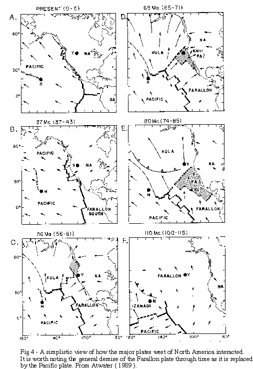
52-48 Ma : The first Farallon breakup was seen. A slight change in direction shows the north of the Mendocino Fracture zone created the new Vancouver plate. This moved almost due east about 20 degrees clockwise of the Farallon plate to the south. The exact area of breakage occurred between the Pioneer and Murray fracture zone which acted like a neck between the two plate motions. Figure 4 shows this neck and the change in plate motions at about chron 21. However, even though a break can be discerned, it is believed that the Vancouver Plate assumed much the same trajectory as Farallon at least for the next 10 million years.
30 —28 Ma : The thin neck between the Pioneer and Murray fracture slowed suddenly to half its previous rate and changed direction 30 degrees clockwise. There is also evidence of the formation of two microplates ; Monterey and Arguello as two separate sets of spreading and direction can be seen in the paleomagnetic record (fig 5).
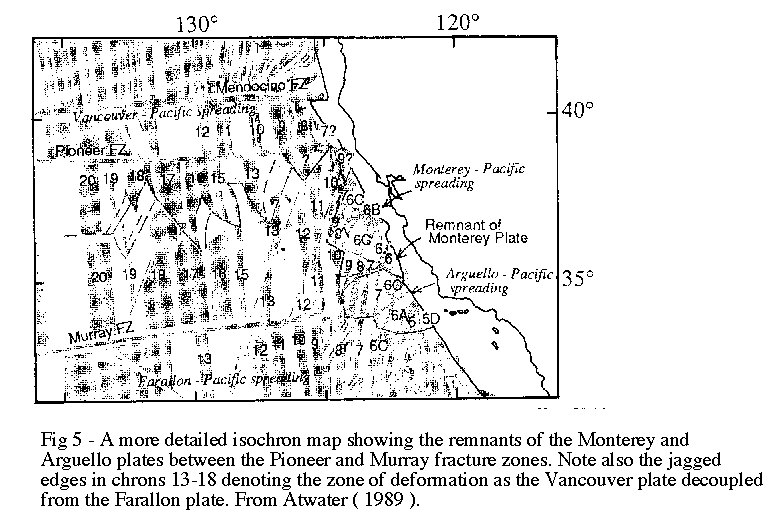
It is thought that that due to the change of motion that it is reasonable to assume that these microplates were partly coupled to North America at this time. It is at this time that contact was effectively lost between the Farallon plate to the south and the renamed Juan de Fuca (JDF) plate to the north.
28 Ma : The first slab window ( discussed later in the web site ) appeared as the Monterey microplate moves away from the JDF plate leading to the first coupling of the Pacific plate and North America just south of the Pioneer fracture zone. As the Pacific plate was moving approximately north west relative to North America, a very different plate boundary was formed. Before this there had been oblique subduction but after the coupling there was dextral transtension which has lead both to the strike slip San Andreas ( which is right lateral ) system and a large amount of extension within the US ( also discussed later ).
The slab window or gap then continued to propagate north and south as larger areas of the Farallon plate stalled and their corresponding downgoing slabs broke away.
20-18 Ma : The Monterey plate stalled just before its capture by the Pacific plate. This was followed about 1-2 million years later by the capture of the Arguello as it too stalled. At this point the San Andreas became an integrated system bordered by triple junctions to the north and south ( Mendocino and Rivera ).
I have not included any of the deformational events that occurred within the continental US but they are looked at in the deformation page. It is believed that as time progressed the San Andreas has steepened eastwards through time which makes sense as it would have initially have started next to low angle thrust faults ( the old subduction section ) and would have moved stepwise until it was almost vertical as it is today. This development and the fate of the microplates, Monterey and Arguello, are discussed at greater length in Nicholson et al (1994).
A written sequence of events, even supported with figures can often not convey a complete understanding, so I would urge readers to see Tanya Atwater’s movie of the evolution of the northeast Pacific and the western US.
| Intro | Slab Gap | Deformation | References | Disclaimer |