|
 |
| Chu Home | People | Projects | Publications | Classes | Contact | News & Events |
McMurdo Project Detail: |
McMurdo Lidar Project: Introduction
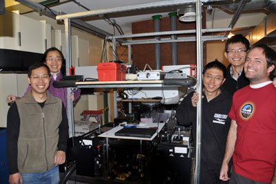
Celebrating the first Fe lidar signals from Arrival Heights, McMurdo. From left: Wentao Huang, Xinzhao Chu, Weichun Fong, Zhibin Yu, John A. Smith. An exciting award from NSF’s Office of Polar Programs funded the Chu Research Group to deploy an Fe Boltzmann lidar to McMurdo, Antarctica to measure the middle and upper atmosphere for three years. Dr. Xinzhao Chu and Dr. Chester S. Gardner, along with their colleagues, developed this lidar more than 10 years ago. With it, we made lidar observations from the North Pole to the South Pole. In particular, we made lidar measurements at the South Pole (90°S) and Rothera (67.5°S) from 1999-2005. Our research group has upgraded this lidar and it has now been deployed to McMurdo (78°S) since November 2010, to complete an observational chain in Antarctica. BackgroundThe Earth's polar regions are more sensitive to global climate change than the equatorial areas. This makes the polar middle-atmosphere temperature an excellent candidate for monitoring climate change. Consider too that increases in CH4 concentrations result in more water vapor content in the middle atmosphere. Combine CO2 cooling and CH4 chemistry, and the result is enhanced conditions for the formation of polar mesospheric clouds (PMC). Thus, these clouds may provide an early indication of climate change. Though polar middle-atmosphere data are vital to better understanding global climate change, the remote and harsh environment makes collecting reliable data a signficant challenge. That's why we developed the Fe (iron) Boltzmann temperature lidar -- an advanced remote sensing instrument. This sophisticated lidar is capable of full-diurnal-cycle measurements of temperature from 30-110 km, and detection of both mesospheric and stratospheric clouds. It measures mesospheric Fe density for both day and night throughout an entire year. By analyzing temperature or density perturbations, we can derive gravity wave potential energy density with this lidar data. Pole-to-Pole Journey of the Fe Boltzmann Lidar We deployed this lidar several times in the past:
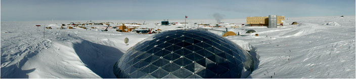
Extensive datasets and significant scientific results on atmospheric temperatures, polar mesospheric clouds, mesospheric Fe density, and gravity waves have been obtained at the South Pole (90°S) and Rothera (67.5°S) with this lidar. Read more about the Past Deployments of this lidar. Current Research Goals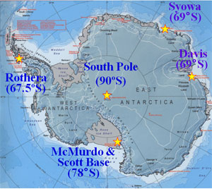 LIDAR stations in Antarctica Although the data gathered between 1999 and 2005 highlighted signficant scientific discoveries, there is a critical data gap in latitude between 90°S and 69°S, especially for range-resolved temperatures and polar mesospheric clouds. While the polar middle-atmosphere is sensitive to climate change, a long-term year-round temperature record has never been obtained in Antarctica – a contrast to the Arctic region. Information about gravity wave properties and large-scale dynamics is lacking in the Antarctic region. We are at the McMurdo Station (78°S, 167°E), mid-way between the South Pole and Antarctic Circle, conducting multi-year lidar observations of polar middle atmosphere to address the following scientific problems:
Long-term project meritsOur long-term goal is to operate the lidar at McMurdo for a complete solar cycle (11 years) to characterize middle atmosphere responses to the solar cycle, annual and inter-annual variations and to extract long-term secular trends to assess climate change in the middle atmosphere. |