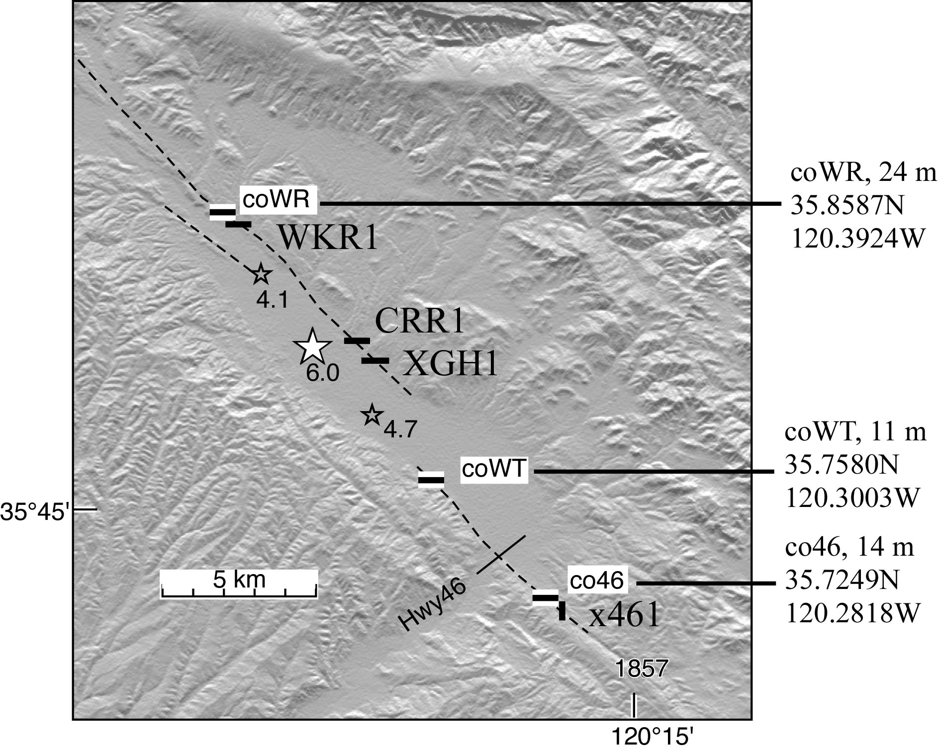
24 Dec 2004: Three University of Colorado creepmeters operate in Parkfield (USGS grant 04HQAG0008). That at Work Ranch (coWR) was activated in April 2004 and the creepmeters at Water Tank (coWT) and south of Hwy46 (co46) were started shortly after the 2004 earthquake. An article discussing coseismic strain and the development of surface fissures in the month following the earthquake may be dowloaded as a pdf file, or viewed as html here.
Work Ranch Creep. The creepmeter at Work Ranch consists of two sensors: a 3-m- range creep-meter with 1.4 mm precision, and a 39 mm range creep-meter with 6 µm precision. Both these sensors recorded coseismic slip. The creepmeter was extended from 10 m long, temporarily to 16 m (21 oct) and permanently to 24 m when, after surface fissures developed, it was discovered to incompletely cross the fault zone. The 15m-long CIT/USGS Work Ranch creepmeter (WKR1) narrowly missed the same fate since its western mount is only 1.2 m west of the westernmost surface fissure. Data from the creepmeter October 2004 to August 2006 are shown below as slip in days after the mainshock.
The data (mm/dd/yy hh:mm:ss UT) are characterized well by a double-exponential fit with the coefficients shown in the figure below (fit in mm, t=days after mainshock). Departures from this fit are most pronounced in the first week of January each year presumably by heavy rain that causes a≈2 mm apparent left lateral signal to be manifest that recovers after <30 days. The trace consists of numerous creep events with ≈1 mm amplitude and interevent timing and duration that increase logarithmically with time. A annual thermoelastic signal with 3 mm amplitude is visible in the data and correlates reasonable well with the 22°C peak to peak annual variation of the rod.
coWR Calibrated afterslip data from WorkRanch 28 May 2004 to 15 August 2004 may be downloaded here as a text file: format UT,volts,dextral slip in mm,degC (Note that the first 21 days following the earthquake were from the creepmeter prior to increasing its length to 24 m to span the active trace, and as a result do not fit any simple slip/time decay curve. Two days of preseismic and coseismic data as text, or view html listing. Data from the 3 m range rupture meter indicate essentially no signal until the time of the earthquake.
Creep SE of the epicenter has asymptotically approached 15 mm in the three months following the earthquake. Data from the two creepmeters are shown below. Interestingly, apart from different creep-event amplitudes, the afterslip amplitude, and its rate of decay, are similar.
co46 Calibrated afterslip data from south of Hwy46 may be dowloaded as numbers co46_date&time_degC_dextralmm with no coseismic offset (listed times 19 s in advance of PDT). Creep events with 1 mm amplitude occurred there initially every 1.5 days. The interval between these increases in the following month and slip all but ceases by the end of 2004. No surface cracks were discernable at this site despite 12 mm of afterslip. Creep has all but ceased at this location although a further creep event is anticipate in late 2006. Soil moisture causes expansion and contraction of the ground by a1-2 mm. . Data to August 2006 may be downloaded here (date UT+dextral slip,mm).
coWT Data reveal creep event that occur at 7-10 intervals with an amplitude of 2-3 mm. No surface cracks were visible 23Dec and cumulative slip is similar to that south of Hwy46. The instrument was equipped with two sensors on 11 Oct: an eastern segment that extends 6 m across the fault, and a western segment 5 m adjacent to the fault. The entire signal occurs in the eastern segment as is evident in the figure.
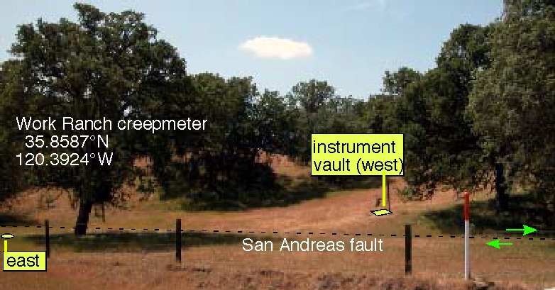
Views of the Work Ranch creep-meter installation are found below.

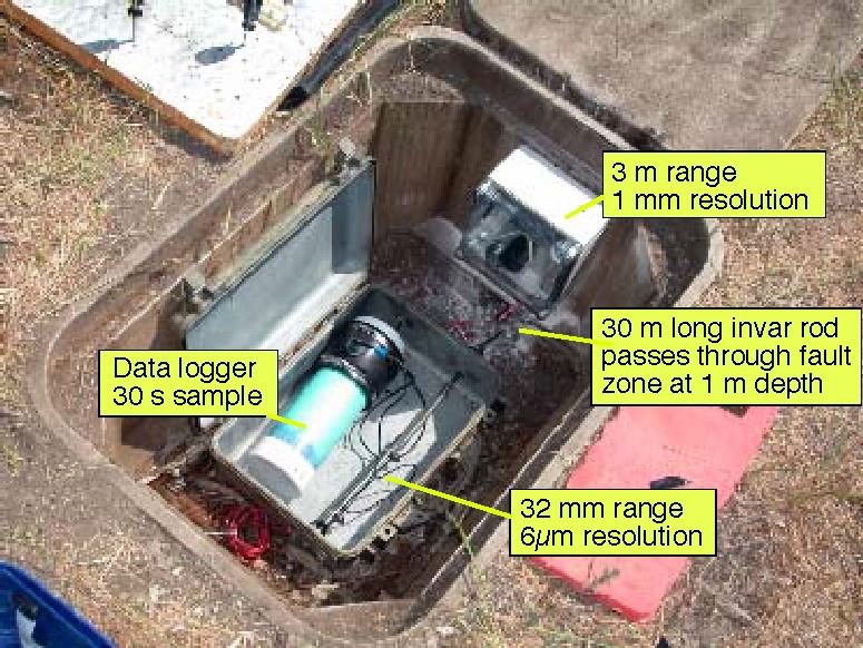
The 14 -m-long, invar-rod Work Ranch creep meter is located at 35.8597°N 120.3924°W. It crosses the fault at 30° and at a depth of 50 cm. The principles of creep meter operation are described in Bilham et al. (2004).[ download pdf.. download word.doc]

Within the 1 m deep instrument vault can be found a coseismic rupture meter with large range & low resolution (3 m and 1 mm respectively), and a high resolution creep meter with 39 mm range. The recording rate is normally once every 5 minutes, which permits unattended operation for 18 months. Both creep meters recorded coseismic slip (3m_range creep-meter data, 3-cm-range creepmeter ). Following the 28 Sept 2004 Parkfield earthquake the sample rate on both systems was increased to 30 seconds.
Until funding was suspended in 1995 four Colorado creep meters operated in Parkfield. In May 2004, following renewed USGS funding, the Work Ranch site was reactivated (See 4 month plot or download GMT indexed text data). Seven hours after the earthquake a second 30 m creep meter south of Highway 46 (co46) was activated. Four days after the earthquake a third creepmeter (coWT) was activated at a location roughly 2 km NW of Highway 46.
THE END OF A MYTH: An important result from USGS and Colorado creep meters that monitored the Parkfield earthquake is that it has ended speculation that precursory creep precedes Parkfield events (and by implication other earthquakes), a myth that started with several anecdotal accounts in 1966 - a pipe broke near Work Ranch 11 hours before the 1966 event, and visitors to the Parkfield area in the days before the earthquake described cracks on the fault. There was no slip on the fault at the surface at the time of the 2004 earthquake, and none visible 5 hours after the event when I collected data from the Work Ranch creep meter on 28 Sept, despite the numerical creep meter data that indicated the presence of 5 mm of fault slip. Presumably this small amount of slip can be absorbed by the fault zone and surface soils as shear strain without developing a clean fracture.
Although the myth persisted as a possible hope that precursory slip might precede a future earthquake, the logarithmic creep decay curves following the 1966 earthquake, and the 1987 Supersition Hills earthquake, both pointed to zero surface slip at times a few seconds following their mainshocks. i.e. most seismologists believed that no precursory surface slip was likely to precede moderate San Andreas earthquakes. There remained hope, however, that strain meters surrounding the hypocenter might capture an acceleration of strain before rupture. If any occurred, it is too small, and of insufficient spatial extent to be of predictive utility.
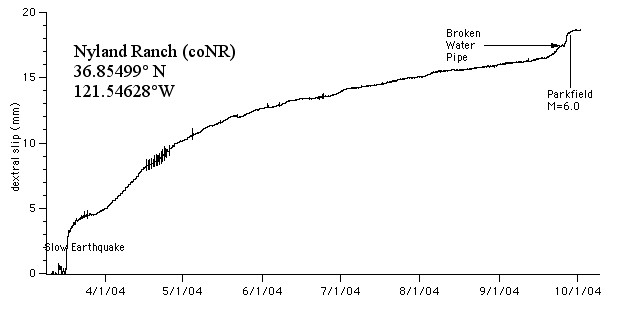
Of curiosity value, a water pipe broke across the San Andreas fault at Nyland Ranch, at the northern end of the creeping zone near San Jaun Bautista, 2 days before the Parkfield earthquake. A nearby creep meter there (coNR is less than 3 m from the fractured pipe) recorded less than 1 mm in the days preceding the fracture. A further 2 mm of slip followed the fracture. The creep event was recorded also by the USGS creepmeter XSJ2. The coNR creepmeter crosses the San Andreas fault at the southermost end of the 1906 rupture (Nyland Ranch link ).
