Updated June'07: The Mw7.6 Kashmir 8 October 2005 earthquake occurred in a region where a great plate-boundary earthquake has long been considered overdue. Although the earthquake resulted in widespread devastation, theoretical considerations suggest it may not have released more than one tenth of the cumulative elastic energy that has developed since the previous great earthquake in the region in 1555 or earlier. Regions to the NW and SE remain to go in future earthquakes since earthquakes in these regions appear insufficently large to fully release cumulative plate motions. This overview places the earthquake in a historical and structural context. The figure below indicates preliminary field mapping of the reactivated Muzafferabad fault (12 Nov), 3-4 m of slip upon which is responsible for the earthquake. For damage commentary see EERI reports.
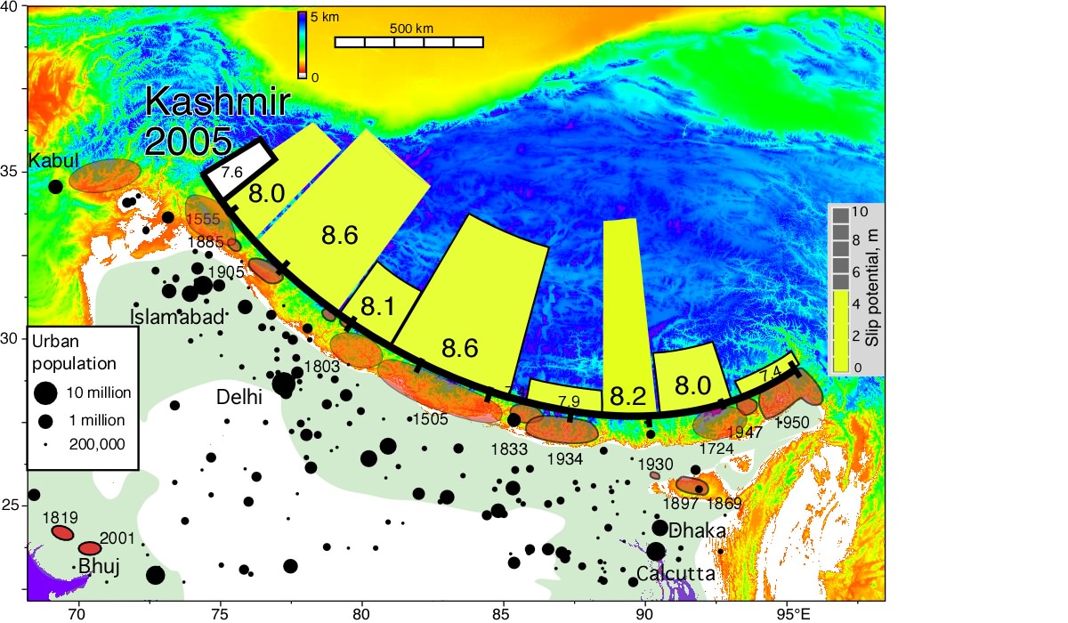
The figures below, published in May 2001 and in May 2005 respectively, illustrate the slip potential developed along the arc (left: red=certain, pink=possible) and the possible size and locations of earthquakes in these regions based on recent findings (right). The area of each yellow region (right) is proportional to estimates of maximum credible earthquake based on potential elastic energy to be released (Bilham and Wallace, 2005). The Kashmir earthquake overlapped the extreme left-hand rectangle. Click for larger image with the Kashmir earthquake superimposed.
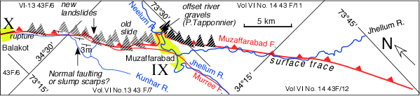
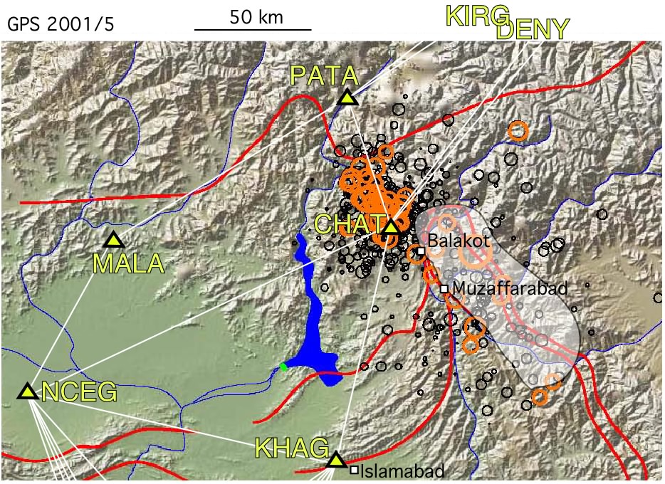
Field Report 12 November 2004 (Roger Bilham and Becky Bendick) Damage and morphological changes in the epicentral region are consistent with satellite imagery and teleseismic data that indicate reverse faulting on a NW/SE striking fault. White shading indicates inferred 40 km x 90 km, 37 degree NE dipping rupture in map-view and cross-section below. Yellow triangles are preseismic GPS points recovered but as yet not processed. Microseismicity & major faults from Nano Seeber. Aftershocks from NEIC.
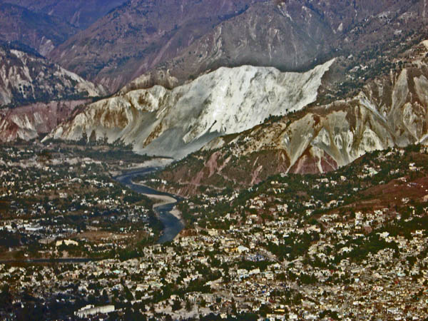
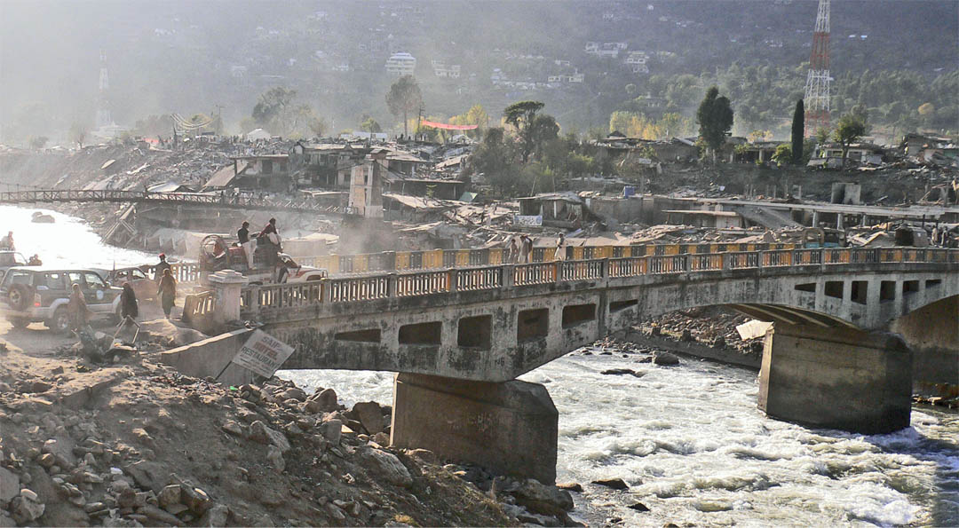
The surface expression of the causal fault is marked by a line of landslides from Balakot to a few km SE of Muzaffarabad that mask surface rupture (if any occurred). The causal fault (see satellite image of fault slip) had been mapped on 1:50,000 Geological Survey of Pakistan map series volume VI no.'s 13 & 14 for 30 km of its NW length as the active Murree/Muzafferabad fault, and for the remainder as an inferred fault. It is probable that rupture approached within 1km of the surface at its NW end, but less close at its SE end. The photo below was taken from a helicopter near Nowsehra looking westward towards Muzaffarabad. Landslides 10 km SE of Muzaffarabad are fewer in number and smaller in size suggesting lower accelerations on the SE half of the 70-80 km long rupture. 80% of concrete frame and masonry structures in Balakot near the NW end of the rupture were totally destroyed although the ≈60 m deck of the concrete arch bridge across the river was unscathed despite translation and abuttment approach of 1-2 m [RFK Intensity IX-X]. In Muzafferabad intensities were judged lower [RFK IX] and in Bagh lower still, with ≈10% destruction of concrete skeleton structures [VIII-IX] and survival of well-built bridges. Click on image for close up of the massive Neelum River slide at the northern end of Muzaffarabad City.
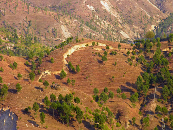
On hillsides not reamed clean by landslides near Balakot, a series of slumps or normal faults have developed above the inferred location of the reverse fault. It is possible that the fault did not approach closer than 1-2 km of the surface. The photo below views westward across the Chaghan Valley approximately 10 km SE of Balakot. Click for contextual view.
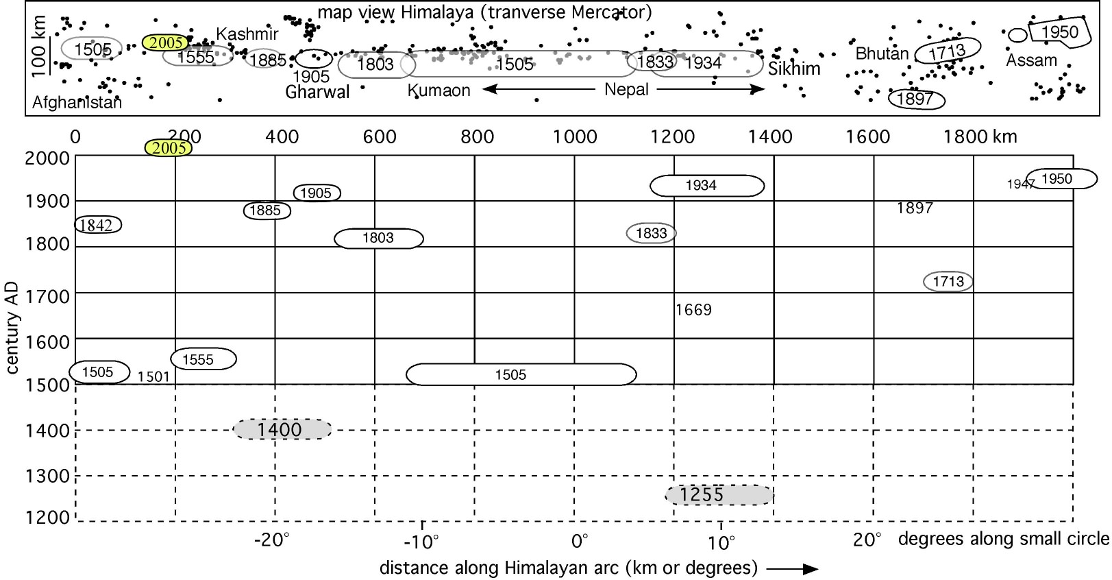
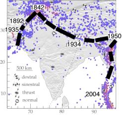
Historical Earthquakes in the Himalaya A previous catastrophic earthquake in Kashmir occurred in 1555 but we have insufficient data to assign it a magnitude or location. Its severity suggests that it may have been larger than the recent earthquake. It may have occurred between the 1905 and 1885 earthquakes. Five decades earlier a moderate Mw≈7.3 earthquake damaged Kabul, and a great 600-km-long 8.2<Mw<8.6 rupture in the central Himalaya destroyed monasteries in Tibet and buildings in Agra. Moderate earthquakes less damaging than the recent 2005 Kashmir event occurred in 1878 M=6.7Abbottabad, 1885 (Mw=6.3) near Srinigar , 1905 (Mw7.8 Kangra), in 1842 (Mw7.5 Kunnar), and in 1974 (Mw=6.2 Pattan). In numerous popular accounts since the October earthquake a 1 Feb 1929 deep Mw7.1 Hindu Kush earthquake is erroneously stated to have occurred in northern Pakistan as a Mw=8.

Subsurface complexity : The 1885 and 2005 Kashmir earthquakes were approximately contiguous and may have occurred on the same 37 degree NE dipping ramp (shown schematically above). The 1905 Kangra earthquake, however, is believed to have ruptured part of the shallow-dipping (≈6 degree NE) Himalayan decollement, typical of great Himalayan ruptures to the east. A line on the map above separates the two styles of faulting. Rupture on a steep ramp, as in 2005 effectively short-circuits convergence at the plate boundary, thereby reducing compressional stresses that would otherwise drive decollement rupture. The 1555 Kashmir earthquake is estimated to have been Mw=7.6 by Ambraseys and Douglas (2003) but may have been much larger. Its location is conjectural as suggested by the red ellipse. If this entire region slipped in 1555 it now has replenished >7 m of potential slip, sufficient to drive a Mw≥8 earthquake.
Intensity distribution
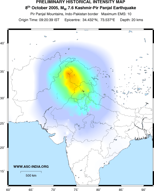
Using internet responses and reports in newspapers, a map of the decay in shaking intensities as a function of distance from the epicenter has been developed by Stacey Martin at the ASC. The preliminary version of this map shown here illustrates the long reach of the earthquake ranging from Intensity X near the epicenter (red=total destruction), to barely felt (violet), beyond distances of hundreds of km. Click for original. Compare with Susan Hough's intensity distribution for the 1905 Mw=7.8 earthquake.
How bad was it? The number of fatalities exceeds 86,000 (7 Nov) making it by far the most fatal earthquake ever to occur in the Indian subcontinent or its surrounding plate boundaries . The number of fatalities in an earthquake is linked to the vulnerability of local buildings, population density, and shaking intensity. In 1935 a Richter magnitude M7.5 strike-slip earthquake near the city of Quetta, the only large settlement in an otherwise sparsely populated region of Afghanistan, Pakistan and Baluchistan, resulted in an estimated 35,000 dead. The M7.8 Kangra earthquake in 1905 caused 20,000 fatalities, and the Mw=7.6 Bhuj 2001 earthquake 18,500.
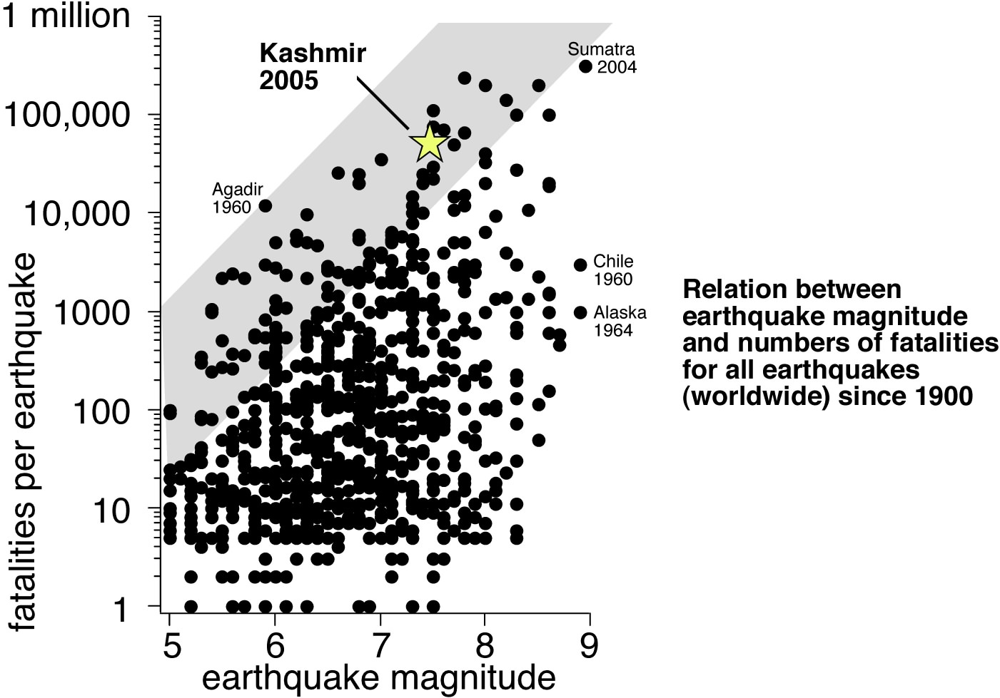
Although a simple relation between earthquake magnitude and the number of resulting deaths can be discerned (gray shading), the fatal consequences of large earthquakes depends more on their proximity to urban populations, the vulnerability of dwellings, and the time of day, than on the energy released. (figure after Hough & Bilham,2005). The Sumatra/Andaman/Nicobar earthquake resulted in epicentral building collapse and damage, and huge loss of life along a thin but concentrated population on a coastal strip throughout the Indian ocean and Andaman sea.
Is this a foreshock to a larger quake? Probably not, but we have so few well-documented examples of Himalayan earthquakes that it is conceivable that another earthquake could occur. The damaging Kashmir 1555 earthquake was preceded in 1501 by a damaging earthquake of unknown magnitude also in Kashmir. Also it is known that Himalayan earthquakes can trigger others. For example in 1833, two major earthquakes preceded the Mw=7.8 mainshock in Nepal by 5 hours and 15 minutes respectively, alerting local residents and resulting in a very minor loss of life. The 1909 Afghan earthquake consisted of two events 1 minute apart, and the 1905 Kangra earthquake had a M7 earthquake embedded in its coda some 7 minutes after the mainshock. We know of no great earthquake triggered days to months after a major earthquake in the same region. However, speculation initiated by the recent Sumatra earthquake that the rupture zones of even quite large earthquakes can re-rupture, suggests that recent M≤7.9 ruptures cannot be considered immune to premature failure in a larger earthquake (Bilham and Wallace, 2005, Feldl and Bilham, 2005).
Landslides in the region may result in floods in the next few months. This Aster image processed by Eric Fielding shows the 3 km path of a landslide near the epicenter that has over-ridden a facing spur and dammed two tributaries of the Jhelum river top right. Lakes will grow upstream (to the left and below) until the dam is breached. A catastrophic downstream flood may occur should the dam not breach early in reservoir development.

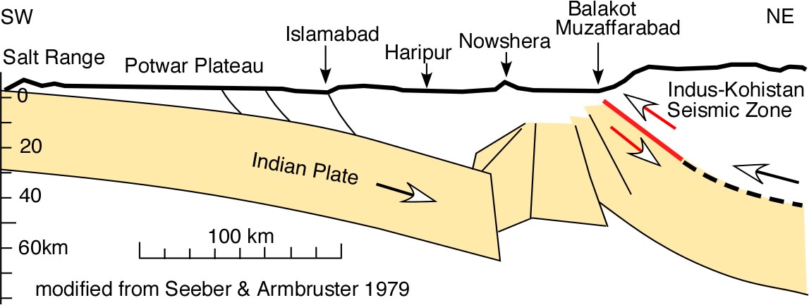
Tectonic setting Earthquakes occur throughout the Indian subcontinent but most are located along the plate boundaries to west, north and east. The 1935 Mw=7.5 Quetta earthquake occurred on part of the left-lateral Chaman fault system on the western boundary. The 2004 Mw=9.3 Sumatra/Andaman earthquake ruptured the right lateral eastern plate boundary. In contrast, the Kashmir 2005 earthquake occurred near the western end of the Himalaya. Thrust earthquakes here signify the descent of India beneath Tibet. The structure on which the mainshock occurred - the Hazara syntaxis - is known to be among the most active in the Himalaya, with local uplift rates in the past several thousand years of ≈1 cm/yr.
.
References 2000-2005
Ambraseys, N., and R. Bilham, A note on the Kangra Ms=7.8 earthquake of 4 April 1905. Current Science, 79, 101-106, 2000.
Ambraseys, N., and R. Bilham (2003), Earthquakes in Afghanistan, Seism. Res. Lett., 74(2), 107-123. Electronic supplement
Ambraseys, N., and R. Bilham, MSK Isoseismal intensities evaluated for the 1897 Great Assam Earthquake, Bull. Seism Soc. Am.93 (2) 655-673, 2003
Bilham, R. (2005) A flying start followed by slow slip. Science, 308(5725),1126.
Bilham, R. and P. England, Plateau pop-up during the great 1897 Assam earthquake. Nature,410, 806 - 809 (2001)
Bilham, R., V. K. Gaur and P. Molnar, Himalayan Seismic Hazard, Science, 293, 1442-4, 2001.
Bilham, R., and N. Ambraseys, (2004) Apparent Himalayan slip deficit from the summation of seismic moments for Himalayan earthquakes, 1500-2000, Current Science, 88(10), 1658-1663, 2005.
Bilham, R., E. R. Engdahl, N. Feldl and S. P. Satyabala. 2005 Partial and Complete Rupture of the Indo-Andaman plate boundary 1847-2004, Seism Res. Lett, 76(3), June 2005.
Bilham, R., R. Bendick, and K. Wallace, (2003). Flexure of the Indian Plate and intraplate earthquakes, Proc. Indian Acad. Sci. (Earth Planet Sci.),112(3) 1-14
Bilham, R., Slow tilt reversal of the Lesser Himalaya between 1862 and 1992 at 78°E, and bounds to the southeast rupture of the 1905 Kangra earthquake, Geophys. J. Int (2001) 144, 1-23.
Feldl N & R. Bilham, Great Himalayan Earthquakes and the Tibetan Plateau, submitted to Nature 2005.
Hough S. E., R. Bilham, N. Ambraseys, and N. Feldl, Revisiting the 1897 Shillong and 1905 Kangra earthquakes in northern India: Site Response, Moho reflections and a Triggered Earthquake, Current Science, 88(10), 1632-8, 2005.
Hough, S and R. Bilham, (2003) Shaken to the Core, Natural History Magazine, 112(1),42-48.
Hough, S. E. R. Bilham, N. Ambraseys and N. Feldl, (2005)., The 1905 Kangra and Dehra Dun earthquakes, Geol. Surv. India Spl. Pub. 85, 15-22.
Paul, J., Burgmann, R. Gaur, V. K. Bilham, R. Larson, K. M. Ananda, M. B. Jade, S. Mukal, M. Anupama, T. S. Satyal, G., Kumar, D. 2001 The motion and active deformation of India. Geophys. Res. Lett. 28 (4) , 647-651, 2001.
Schulte-Pelkum, V., A. Sheehan, F. Wu, R. Bilham, Imaging the Indian Subcontinent beneath the Himalaya, Nature,435, 1222-1225, 30June 2005
Wallace, K.; Bilham, R.; Blume, F.; Gaur, V. K.; Gahalaut, V.,(2005) Surface deformation in the region of the 1905 Kangra Mw = 7.8 earthquake in the period 1846–2001, Geophys. Res. Lett., Vol. 32, No. 15, L15307, 10.1029/2005GL022906