 |
 |
| Pielke Home | People | Publications | Images | Courses | News | Links | Contact |
| RESEARCH GROUPS @ CIRES > |
Large Eddy Simulation of the Lake-ICE Case 19 January 1998 with RAMS
Adrian Marroquin* and Roger A. Pielke Sr.**
NOAA Research-Forecast Systems Laboratory
Boulder, Colorado
*[In collaboration with the Cooperative Institute for Research in the Atmosphere (CIRA), Colorado State University, Fort Collins, Colorado]
(**) Department of Atmospheric Sciences, Colorado State University, Fort Collins, Colorado, 80523-1375
ABSTRACT: A large eddy simulation (LES) was performed using the Regional Atmospheric Modeling System (RAMS) for one of the cases, 19 January 1998, from the Lake-Induced Convection Experiment (Lake-ICE). This study tests the ability of RAMS to describe the influence of surface inhomogeneities on the boundary-layer circulations, and tests the possible use of RAMS as a forecasting tool in an LES configuration for assessing the impact of dangerous pollution dispersion events on short notice. The model was initialized with the National Centers for Environmental Prediction (NCEP) reanalysis data. A qualitative verification of the LES output was performed using the animations of lidar (used in the Lake-ICE) observations and other data provided on the Lake-ICE webpage. Despite the coarseness of the initial and boundary data, the LES results show good agreement with boundary-layer features observed by the lidar. It is then possible that given the proper fine local-scale observations and computer resources, RAMS could be used as a forecasting tool in emergency situations.
KEYWORDS: large eddy simulations, RAMS, Lake-ICE, surface inhomogeneities
1. Introduction
The impact of surface heterogeneities (topography, vegetation, soil moisture and type) into the adjacent atmosphere has been studied by several researchers (Pielke, 2001; Avissar et al., 2002). It has been long recognized that these heterogeneities are important in organizing planetary boundary-layer circulations such as convective rolls, severe storm triggering mechanisms, as well as sea breezes. The long-term effects of these interactions are suspected in the modification of climate.
Weaver and Avissar (2001, 2002) investigate the significant atmospheric effects of human modification of the landscape. Using observations and results from RAMS (Pielke et al. 1992), they find that differential land use patterns generate thermally-induced mesoscale circulations significant enough to impact the local weather, and in the long term, the climate. These surface inhomogeneities, small in spatial and temporal scales, demand very small grid spacings such as used in large eddy simulations (LESs). Weckwerth et al. (1997) examine the importance of environmental conditions necessary to maintain boundary-layer convective rolls. Their numerical simulations with the Clark (1977) model reveal that moderate surface sensible heat flux and vertical shear are necessary for roll existence. The initial conditions were horizontally homogeneous with random perturbations imposed on the heat flux necessary to generate the rolls. The model was integrated (100 m grid spacing in the lowest 3 km) using cyclic boundary conditions. Eastman et al. (1998) highlight the importance of using realistic soil moisture obtained from objective analyses of field data taken during the First International Satellite Land Surface Climatology Project (ISLSCP) Field Experiment (FIFE). Avissar et al. (1998) present the results of LESs for a convective boundary-layer (CBL) case, 1 July 1987, during FIFE. Different spatial distributions of topography and surface heat fluxes were prescribed. They compared the simulated turbulence structures with those obtained with the volume-imaging lidar (VIL). Their model results (100 m grid spacing) with lidar and sounding data show an acceptable model performance. However, they report deficiencies of the Deardorff 1.5-order-of-closure subgrid-scale turbulence parameterization in describing the energy cascade. Furthermore, their different simulations show that topography scales of the order of 100 m and fine structures in the surface fluxes had modest impact on the CBL circulations over a relatively humid surface.
In the present work, the influence of surface heterogeneities on the boundary-layer circulations at fine grid spacings is investigated with the RAMS numerical model. An objective in this effort is to perform a thorough verification of the model performance for case studies for which there are field observations. For this purpose, we have selected a couple of cases from the Lake-Induced Convection Experiment (Lake-ICE). Mayor and Eloranta (2001) from the University of Wisconsin have collected and prepared lidar data that are available for the present studies. The lidar data animations for several of the Lake-ICE cases are presented in the Web page http://lidar.ssec.wisc.edu/experiments/wisc98/jan. In particular, the 19 January 1998 case can be seen on the webpage http://lidar.ssec.wisc.edu /experiments/wisc98/jan/011998/index.htm. Tripoli (1992) from the University of Wisconsin has completed several simulations for the Lake-ICE which are posted on the website http://lidar.ssec.wisc.edu/les/les.htm. These simulations were performed with the University of Wisconsin's scalable nonhydrostatic modeling system (UW-NMS). To facilitate the simulations, periodic boundary conditions were used which can help reduce the domain size and therefore lessen computer resources. In some of the numerical experiments, the upstream initial conditions have been perturbed to simulate the generation of large eddies downstream.
We attempt to investigate the possible use of RAMS in a nested grid configuration without resorting to simplifications of boundary and initial conditions. The main motivation for this approach is that, given adequate computer resources, the model could be run in emergency situations when a pollutant dispersion is a threat to society requiring environment and damage assessments on short notice. The model configuration is similar to the one in use for weather forecasting. It is clear that a skillful simulation (forecast) depends on the accurate description of the initial atmospheric state and subsequent atmospheric variables at the lateral boundaries. This is in itself a challenge because observations for initial and boundary conditions are not always available with adequate resolution and domain coverage. With our LES results for the Lake-ICE 19 January 1998 case, we attempt to address issues such as the model initialization, boundary conditions, and physics that need to be resolved for the model forecasts to be useful in emergency situations. In respect to computer resources, the disadvantage is that a large domain is needed to provide the necessary upstream perturbations (from terrain, vegetation, etc.) for the internal boundary-layer evolution. However, with a large domain the upstream perturbations are more realistic than artificially imposed ones.
2. Model Configuration and Physics
The RAMS model is set up with three nested grids centered at the lidar location near Sheboygan, WI. The grids are defined as follows: the outermost grid, 122 x 122, has a grid spacing of 450 m; the next grid, 202 x 202, 150 m; and the innermost grid, 202 x 202, 50 m. A total of 31 levels are used in the vertical with spacings that start at 24 m above the ground and slowly increases to 180 m at 1 km. The top of the model reaches 17.4 km.
The model physics comprises the Land Ecosystem-Atmosphere Feedback (LEAF-2) soil model; bulk microphysics (including prognostic variables for clouds, rain, pristine ice, snow, aggregates, graupel, and hail); and the short- and long-wave radiation (Chen and Cotton, 1983) scheme. No convection parameterization is used in any of the grids. An absorbing layer is used at the top of the model while a Klemp and Wilhelmson (1978) condition is used at the lateral boundaries. For the subgrid-scale fluxes, the Deardorff (1980) turbulence scheme is used for the two inner grids while the Mellor and Yamada (1982) turbulence scheme is used for the outer grid. For further description of the RAMS model see Pielke et al. (1992) and Pielke (2002; Appendix B).
3. 19 January 1998 Case Study
3.1 Brief Weather Overview
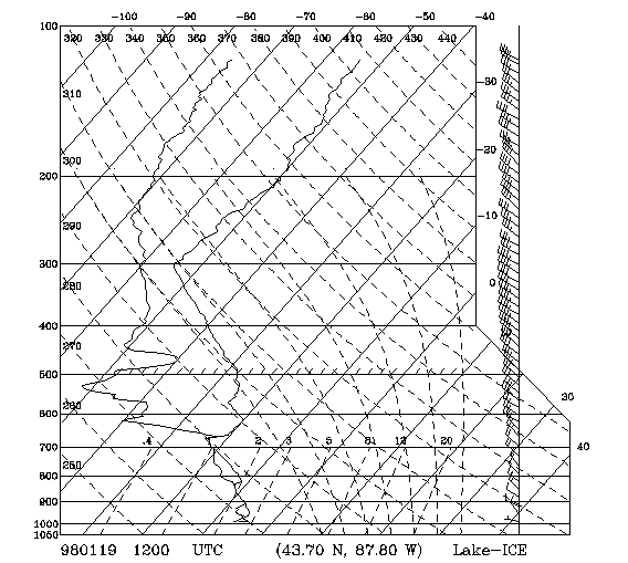
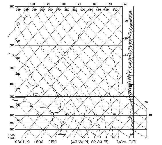
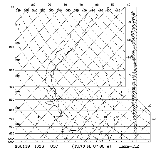
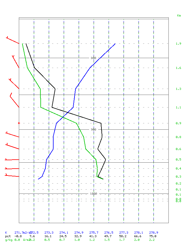
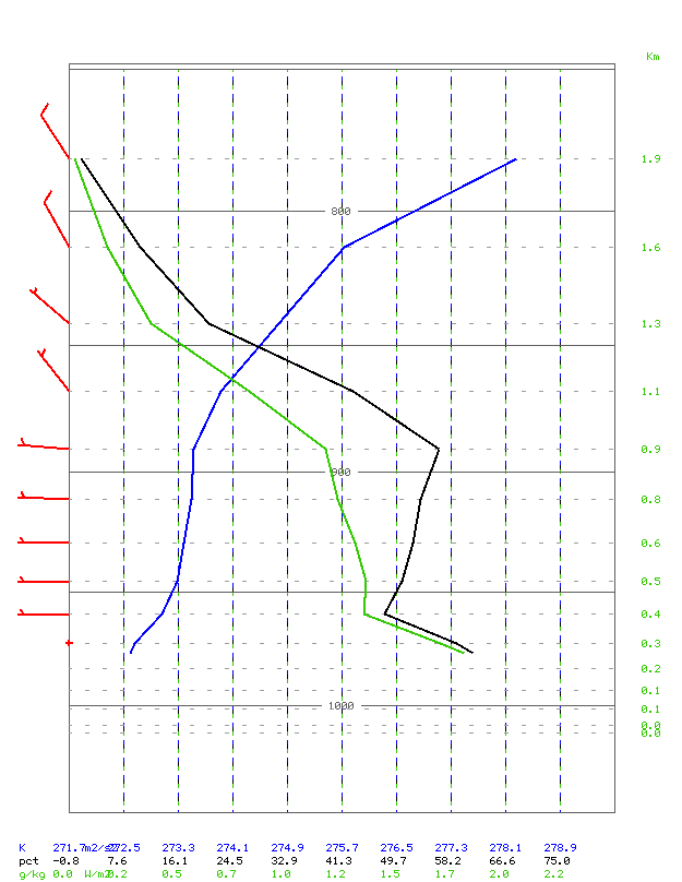
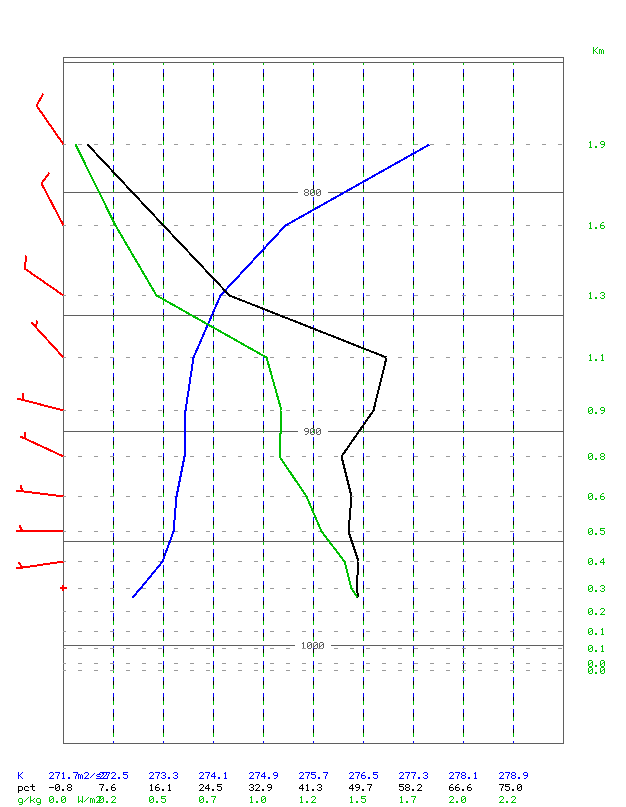
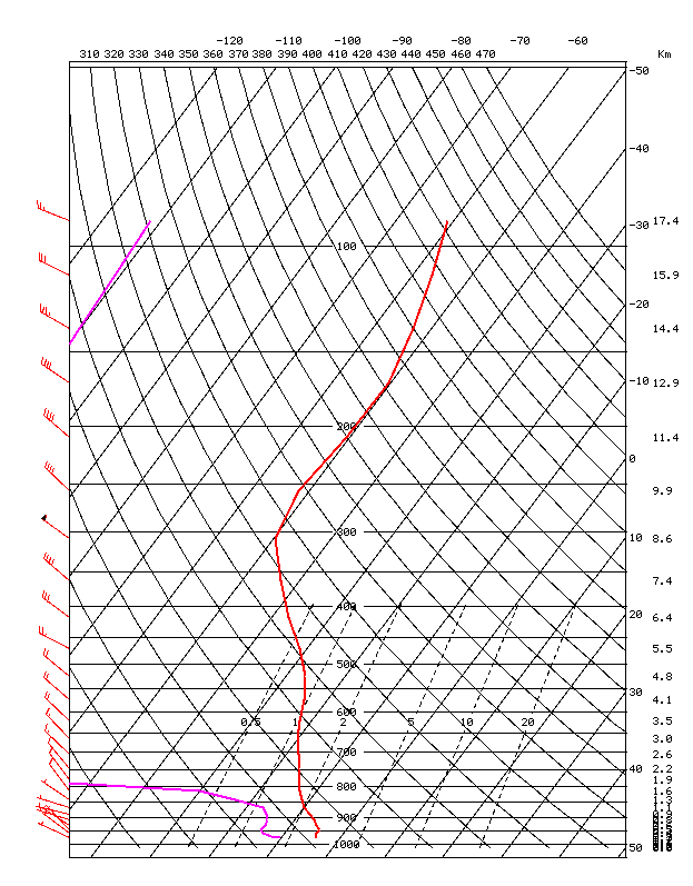
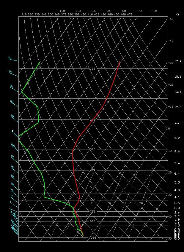
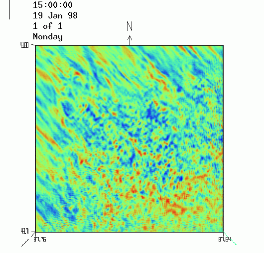
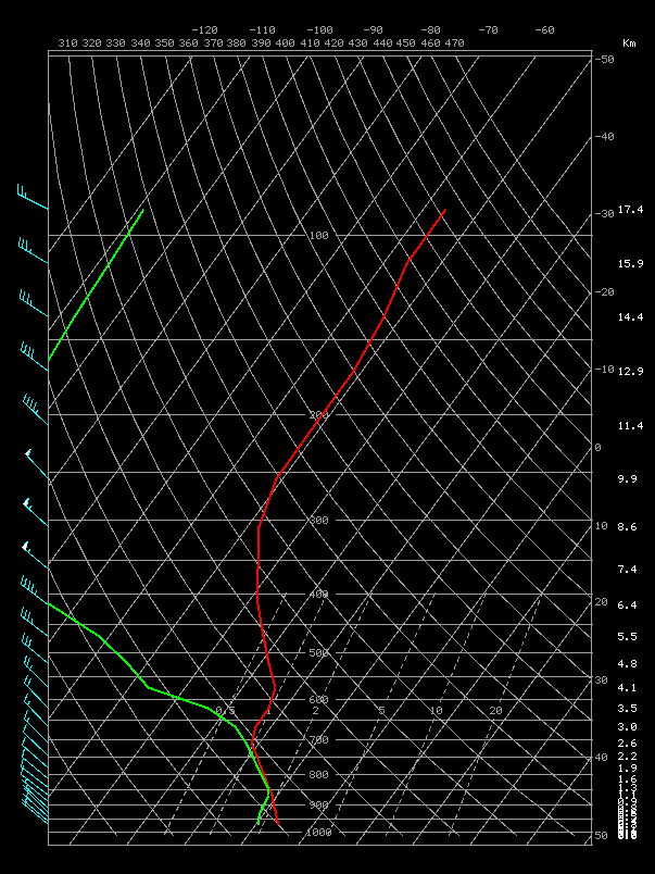
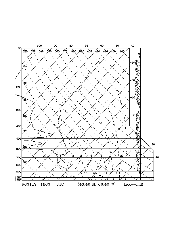
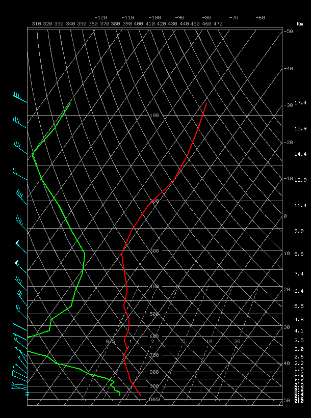
The Lake-ICE 19 January 1998 case selected for this study was run with RAMS in an LES configuration. The lidar data animations for this case are posted on the Lake-ICE webpage. The vertical cross sections and PPI from the lidar scans show the evolution of the boundary layer. The flow in this case is from the northwest. The evolution of the weather conditions near the lidar location (east of the city of Sheboygan, WI) can be viewed in Figs. 1-3. The predominant flow is from the northwest with weak winds in the boundary layer. At 1200 UTC (Fig. 1) there are two weak inversions below 800 mb and a strong inversion below 680 mb with a couple of saturated layers. At 1500 UTC (Fig. 2) two main inversions are observed below 650 mb with drier conditions than at 1200 UTC. At 1630 UTC (Fig. 3), a weak inversion is observed below 870 mb while the layer from 680 mb down to the surface is saturated. Considerable moisture advection has occurred from 1500 to 1630 UTC. It is important to note that the Range Height Indicator (RHI) lidar scan, Fig. 4, (on the Lake_ICE webpage) shows significant backscatter intensity in a layer from the surface up to 250 m, while the saturated layer (shown in the sounding, Fig. 3) extends up to the 680-mb level.
3.2 Model Initial Conditions
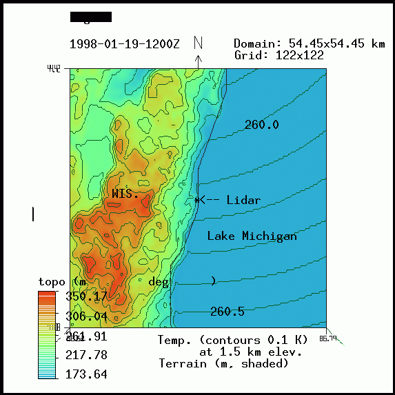
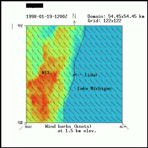
The initial and boundary conditions for this case were taken from the NCEP reanalysis data. The surface conditions are defined using the United States Geological Survey data. Figure 5 shows the topography (shaded) and the temperature (contours) at 1.5-km elevation for 1200 UTC 19 January 1998 as given by the NCEP reanalysis data. The domain corresponds to the outermost grid (122 x 122, 54.45 km x 54.45 km). The lidar location and other geographical features are indicated. The boundary between land and water is shown by the black contour. Figure 6 shows the winds for the same elevation and grid.
Figure 7 presents the winds at 0.5-km elevation for the innermost grid (202 x 202, 10 km x 10 km) for 1200 UTC 19 January 1998. The blue contours show the terrain. The Snd and lidar signs on this figure serve as guidance for the locations of the soundings that are shown in the next three figures, Fig. 8 (Snd-1), Fig. 9 (Snd-2), and Fig. 10 (lidar), respectively. The temperature, relative humidity, and mixing ratio are indicated by the blue, black, and green contours, repectively. These figures show that the layer from the surface to 1.9 km is not as moist as indicated by the sounding on Fig. 1. The inversions are not correctly described although the winds (red) are qualitatively similar to those on Fig. 1. The shortcomings in the ability of the available routine synoptic data to initialize the high spectral resolution RAMS model indicates that supplemental initial data are needed for more realistic initial conditions.
The land west of Lake Michigan was covered with snow with the temperature over the lake at about 4.5 degrees Celsius warmer than the temperature over land (see temperature at 2 m, Fig. 11). This information was obtained from the USGS dataset.
3.3 19 January 1998 Large Eddy Simulation
The RAMS model was integrated from 1200 UTC to 1800 UTC. During the first 3.5 h the field variables show a process of adjustment with considerable noise eliminated during this time interval. Figure 11 (for the external grid, 122 x 122) shows the winds at 100 m and the temperature at 2 m above the surface, respectively at 1530 UTC. Considerable adjustment of the winds to the land features has occurred in the first 3.5 h. The temperature at 2 m above the surface is warmer by 4.5 degrees over the water than over land. This variability of the temperature and winds over land is important in the formation of the internal boundary layer (IBL) that develops downstream over the water. Figure 12 shows a sounding (from model output) for 1530 UTC at the lidar location taken within the innermost grid (202 x 202). Comparing this with the observed Sheboygan sounding (Fig. 2), in the model, the layer up to 800 mb is about half as moist as the real sounding with the temperature slightly warmer. Above 800 mb the model shows a very dry layer. This is because the NCEP reanalysis data are very coarse and not representative of the local conditions at Sheboygan.
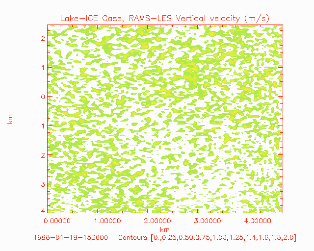
The atmospheric conditions at 1530 UTC, described above, seem to be adequate to continue the LES up to 1800 UTC. The animation in Fig. 13 shows the vertical velocity interpolated to the lidar scan cone (elevation 1.5 degrees) from 1530 to 1600 UTC. The lidar scan covers about 10 km in the east-west direction and 7 km from north to south. The RAMS-LES domain of the innermost grid, used in the simulation, covers an area 10 km x 10 km (50 m grid spacing), and since the lidar location is approximately at the center of the grid, the area that can be used for comparison with the Lake-ICE lidar animation is indicated by scales (km) on the horizontal and vertical axes of Fig 13. In both Fig. 13 and Fig. 14, the lidar is located at the coordinate (0,0). Comparison of this animation with the one available on the Lake-ICE webpage, Fig. 14, shows good agreement in the flow direction and generation of small isolated clouds (reflected in the vertical velocity). The model animation shows a tendency for the vertical motions to be organized in elongated patterns in small areas. This may be due to the coarse grid spacing (50 m) when compared with the 15 m scales that the lidar can resolve. In this model animation gravity waves can be observed propagating from southwest to northeast. This feature can be also observed in Fig. 14 animation. The source of these gravity waves seems to be a combination of wind shear with height and vertical motions (of the order of 2 m/s) within the lower inversion.
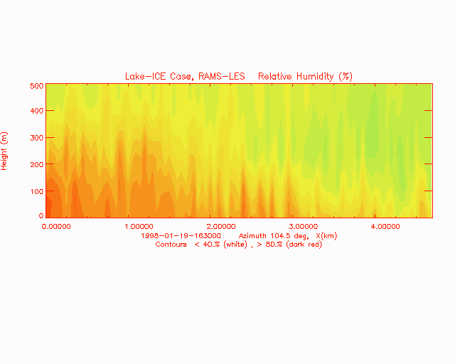
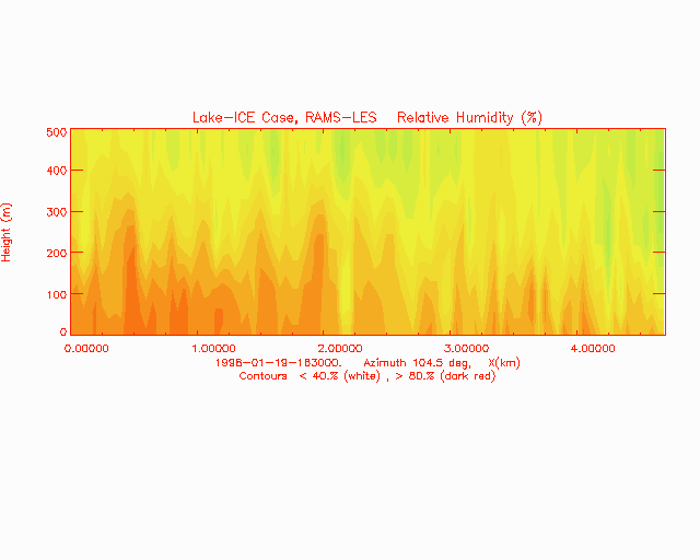
The model boundary-layer evolution is shown in the Fig. 15 animation. The relative humidity is shown on a vertical cross section oriented at an azimuth of 104.5 degrees passing over the lidar (located at the origin on Fig. 15) from 1630 to 1730 UTC. On the Lake-ICE webpage, the mpeg animation in Fig. 4 shows the lidar RHI. The horizontal and vertical axes are labeled in km to show the area of Fig 15 that can be compared with Fig. 4. In both figures the lidar is located at the origin. The model boundary-layer evolution is qualitatively similar to its lidar counterpart. Toward the end of the animation (1730 UTC), the model shows excessive boundary-layer growth, which indicates that the stability within the boundary layer has not been correctly described in the model's initial and boundary fields.
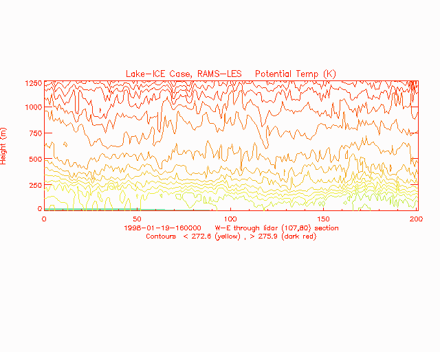
Examination of the Lake-ICE webpage images suggests that there are two inversions, one from the surface to about 250 m and an overlying inversion to about 750 m from 1500 to 1730 UTC. A vertical cross section of the potential temperature evolution from 1600 to 1800 UTC, from west to east (passing over the lidar location), is shown in the Fig. 16 animation. Two inversions can be seen in this animation. As in the previous animation for the relative humidity, there is excessive growth of the boundary layer toward 1730 UTC.
4. Sensitivity Studies
The LES shows (see sec. 3.2) an excessive dryness in and above the boundary layer, and an excessive boundary-layer growth toward the end of the simulation. These deficiencies seem to be related to the poor description of the initial and boundary conditions. To investigate the influence of more realistic initial and boundary conditions upon the LES results, the temperature and dewpoint in the initial data were corrected such as there is agreement with the same variables from the Lake-ICE sounding at 1200 UTC taken at Sheboygan, WI. Also, to ameliorate the excessive boundary-layer growth toward the end of the simulation (1800 UTC), the temperature and dewpoint at the lateral boundaries were corrected to agree closely with the Sheboygan sounding at 1800 UTC. A new LES was performed with these modified conditions.
a) Modified initial and boundary fields
At the end of the third hour, 15000 UTC, the boundary layer (surface to about 650 mb) has evolved to an atmospheric state very different from the one observed by the lidar (Fig. 17). It also differs from the previous LES. The planetary boundary layer remains very moist from the surface to 680 mb with dewpoints similar to those shown on Fig. 2. Figure 18 shows a sounding at 1500 UTC obtained from model results at the center of the domain. This figure shows a more neutrally stratified and saturated layer from the surface to 920 mb, which is different from the conditions shown in Fig. 2. A closer look at the boundary layer as seen by the lidar (starting at 1235 UTC, Fig. 19) reveals a large horizontal variability in the lidar backscatter in the form of deep and fast moving moist regions . It is possible that the sounding (at 1200 UTC) may have been taken through a small patch of saturated air around the sounding site at Sheboygan and therefore it is not representative of a larger domain. This statement is supported by the animation in Fig. 19.
Besides the differences mentioned in the previous paragraph, the vertical velocity patterns (Fig. 20) at the end of the 3-h simulation begin to appear above 920 mb (approx. 500 m). In contrast, in the previous simulation (Sec. 3.3) these patterns are present in a layer from near the surface to 300 m, which agree closely with those observed by the lidar (Fig. 14). In the present LES, the magnitude of the vertical velocity (pattern elements) increases gradually from 500 m, reaching a maximum at about 1 km, then it begins to decrease toward the 3 km level. This evolution is anticorrelated with the evolution of the dewpoint temperature such that the maximum vertical velocities are just above the driest layers. The results from the simulation with modified initial/boundary fields, even though incorrect, provide a plausible explanation for the vertical velocity pattern formation. In order to simulate the vertical velocity patterns (seen by the lidar, Fig. 14) we need a progressively drying layer above a neutral or unstable moist layer.
b) Modified 1800 UTC boundary fields
Since the LES with the modified initial and boundary fields did not
provide satisfactory results, it was then decided to test the influence
of modificatons of the
1800 UTC boundary fields on the boundary layer development. An LES
was performed, starting at 1500 UTC, with the unmodified initial and boundary
fields
allowing the variables at the lateral boundaries to be updated
using the unmodified 1200 UTC and the modified 1800 UTC boundary fields,
respectively. Figure 21 shows the temperature
(red) and dewpoint (green) for 1800 UTC at the lateral boundaries (modified),
and Fig. 22 shows the same variables from
an 1800 UTC sounding at Sheboygan, WI. At the end of the simulation, 1800
UTC, and at the center of the innermost grid the temperature and dewpoint,
Fig. 23 shows a more moist boundary layer than in the original LES. It
should be noted that the 1800 UTC sounding at Sheboygan, Fig.
22, reflects the local atmospheric conditions while the model sounding,
Figure
23, is the result of model integration influenced by the lateral boundaries.
Figure 24 (animation) shows the evolution of the relative humidity (RH, shades of color, %) on a vertical cross section, at an azimuth of 104.5 degrees, with the lidar located at the origin, from 1630 to 1730 UTC. When comparing the vertical extent of large RH values (dark red) with those of Fig. 15, the new LES shows a boundary-layer growth more in agreement with the lidar observations. This sensitivity experiment demostrates the importance of having the proper network of observations to provide the model with time and space scales required by the LES grid spacing. This claim is supported in the present study by the need to modify the large-scale conditions provided by the reanalysis data to reflect small scales in the boundary layer.
In all the simulations it was noticed that the RAMS model began to provide
useful results at the end of three and a half hours (spinup). This delay
is related to
the model adjustment to bring the initial and boundary fields into
balance. While this balance process is active, the influence of the surface
heterogeneities is too weak to be significant.
5. Remarks and Conclusions
A large eddy simulation has been performed for one of the Lake-ICE cases, 19 January 1998. The initial and boundary conditions, taken for the NCEP reanalysis data, were shown to portray only large-scale conditions with only a rather poor description of the local area around the lidar location. However, in the boundary layer these conditions were satisfactory for the LES. The use of a large domain (innermost grid, 10 km x 10 km) seem to provide the proper upstream conditions (west of the lake shore) for the IBL to form over the water. It is interesting to note that the temperature difference between land and water evolved from 2.5 degrees at 1200 UTC to 4.5 degrees at 1530 UTC, which is in close agreement with what was observed for 19 January 1998.
Three main features from a comparison between LES results and observations deserve mention:
* The animation of small-scale patterns shown in the vertical velocity, interpolated to the lidar scan surface, resemble those shown in the lidar animation.
* The boundary-layer inversions from the model agree qualitatively with those shown in the Lake_ICE webpage animations.
* The gravity wave activity shown in the vertical velocity animation seems to resemble those observed in the corresponding lidar counterpart.
The main deficiencies observed in the LES are the excessive dryness in and above the boundary layer and an excessive boundary-layer growth toward the end of the simulation. These deficiencies stem from the poor description of the initial and boundary conditions. This strongly suggests that, for a small LES domain, local soundings, and surface observation are needed. This conclusion, of course, is nothing new. However, the main point of the experiment was to determine the effectiveness of the large-scale data for LES work. In our case, the NCEP reanalysis data were only adequate to provide large-scale homogeneous upper-atmospheric and surface conditions, that is, a persistent northwesterly flow coupled with snow-covered land (western half of the domain), and water over the eastern half of the domain.
Our general conclusion is that the RAMS model is capable of describing the planetary boundary-layer evolution despite the coarse initial and boundary conditions, and that, given the proper computer resources and local fine-scale observations, it is possible to use the LES model configuration as a forecasting tool.
6. Acknowledgments
This research is sponsored by the Department of Defense (DoD) Center for Geosiences/Atmospheric Research (CG/AR) at Colorado State University under the Cooperative Agreement #DAAL01-98-2-0078 with the Army Research Laboratory. Thanks are given to Drs. Ed Eloranta and Shane Mayor from the University of Wisconsin for their help in getting access to the animations and data sources from the Lake-ICE webpage. Thanks to Dallas J. Staley at Colorado State University (CSU) and Nita Fullerton at the Forecast Sysrtems Laboratory for their review of the manuscript and to Tara Green (CSU) for helping in the organization of the webpage where the present paper is displayed.
7. References
Avissar, R., E. W. Eloranta, K. Gurer, and G. J. Tripoli, 1998: An evaluation of the large-eddy simulation option of the Regional Atmospheric Modeling System in simulating a convective boundary layer: A FIFE case study. J. Atmos. Sci., 55, 1109-1130.
Avissar, R., C.P. Weaver, D. Werth, R.A. Pielke Sr., R. Rabin, A.J., Pitman, and M. A. Silva Dias, 2002: The regional climate. Part A2 In: Vegetation, Water,Humans and the Climate: A New Perspective on an Interactive System. A Synthesis of the ICBP Core Project, Biospheric Aspects of the Hydrologic Cycle, P. Kabat, Chief Editor, in press.
Chen, C. and W. R. Cotton, 1983: A one-dimensional simulation of the stratocumulus-capped mixed layer. Bound.-Layer Meteor., 25, 289-321.
Clark, T. L., 1977: A small scale dynamic model using a terrain following coordinate trasnform. J. Comp. Phys., 24, 329-350.
Deardorff, J. W., 1980: Stratocumulus-capped mixed layers derived from a three-dimensional model. Bound.-Layer Meteor., 18, 495-527
Eastman, J. L., R. A. Pielke, and D. J. McDonald, 1998: Calibration of soil moisture for large-eddy simulations over the FIFE area. J. Atmos. Sci., 55, 1131-1140.
Klemp, J., and R. Wilhelmson, 1978: The simulation of three-dimensional convective storm dynamics. J. Atmos. Sci., 35, 1070-1096.
Mayor, S. DF., and E. W. Eloranta, 2001: Two-dimensional vector wind fields from volume imaging lidar data. J. Appl. Meteor., 40, 1331-1346.
Mellor, G. L., and T. Yamada, 1982: Development of a turbulence closure model for geophysical fluid problems. Rev. Geophys. Space Phys., 20,851-875.
Pielke, R. A., 2001: Influence of the spatial distribution of vegetation and soils on the prediction of cumulus convective rainfall. Rev. Geophys., 39, 151-178.
Pielke, R. A., W. R. Cotton, R. L. Walko, C. J. Tremback, W. A. Lyons, L. D. Grasso, M. E. Nicholls, M. D. Moran, D. A. Wesley, T. J. Lee, and J. H. Copeland, 1992: A comprehensive meteorological model system. Meteor. Atmos. Phys., 49, 69-91.
Pielke, R.A, Sr., 2002: Mesoscale meteorological modeling. 2nd Edition, Academic Press, San Diego, CA, 676 pp.
Tripoli, G. J., 1992: A nonhydrostatic mesoscale model designed to simulate scale interactions. Mon. Wea. Rev., 120, 1342-1359.
Weaver, C. P., and R. Avissar, 2001: Atmospheric disturbances caused by human modification of the landscape. Bull. Amer. Meteor. Soc., 82, 269-280.
Weaver, C., P., and R. Avissar, 2002: Atmospheric disturbances caused by human modification of the landscape. Reply. Bull. Amer. Soc., 83, 280-283.
Weckwerth, T. M., J. W. Wilson, R. M. Wakimoto, and N. A. Crook, 1997: Horizontal convective rolls: Determining the environmental conditions supporting their Existence and characteristics. Mon. Wea. Rev., 125, 505-526.
Nondiscrimination Policy • Legal and Trademarks |