16 June 1819 Earthquake Chronology of Investigations Bibliography Magnitude Estimates
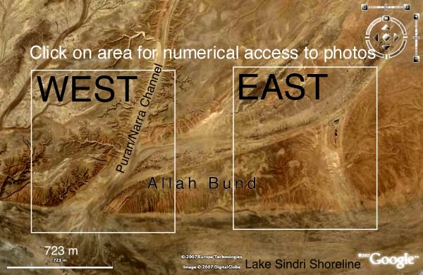
The 16 June 1819 Mw≈7.7 Allah Bund earthquake was responsible for the formation of Lake Sindri in the NW Rann of Kachchh, a basin with dimensions 20 km N/S & 30 km E/W. The lake flooded the village of Sindri and destroyed the fort of that name. Simultaneously a region of elevated ground 6 km wide N/S with an inferred length of 50-80 km E/W (the Allah Bund) dammed the Puram (Pooram) River. The headwaters of the Puram (fed by the Narra River) have long since been diverted and the region is now a desert-like tract except for the saline waters of Lake Sindri. These waters evaporate in the dry season adding to the layers of salt lining the base of Lake Sindri, and are replenished during the monsoon by inflow from the Arabian sea with the construction of an unusual inland-facing delta formed by reworked sediments of the Indus delta. The map view below shows the northern shores of Lake Sindri and the channel of the Puran/Narra River through the Allah Bund. Access to a photo gallery of 187 photos showing the present morphology of the Allah Bund is provided. The morphology is extremely gentle and the relief is only interpretable using precise leveling. Direct access to representative photos are shown in numbered locations on enlarged views of the east or west regions of the Allah Bund (see the map below).
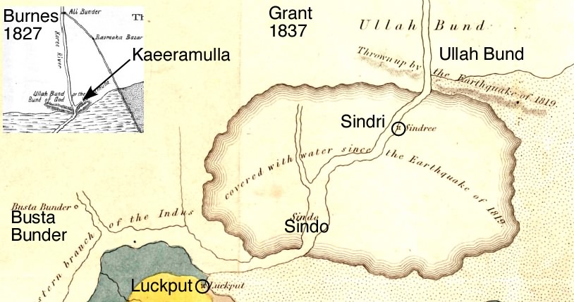
The above map view of the southern edge of the Allah Bund provides access to numbered ground photos. Click on the the west or the east panel to determine the location of interest and the number of the photo. These numbers are the same as those entered in the folder of photos. The ENE trending channel may correspond to the channel labelled Kaeeramulla in Oldham's copy of Burnes' March 1828 map, and Kaera nulla in Burnes' April 1828 map
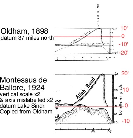
Oldham [1926] summarizes much that is known of this earthquake. Most useful are the contemporary accounts of McMurdo[1] [1820;1823], Burnes[2] [original_1828, 1834], Grant [1837], and Baker[3][1846], and the derivative discussions in Lyell [1850], Wynne[1873], Sivewright [1907], and interestingly, Reid [1911] who invokes the deformation of the Bund as a confirmation of his elastic rebound theory. Macmurdo's pre-1830 historical materials are reproduced in Bilham [1998] together with calculations of numerical estimates of inferred uniform planar co-seismic slip based on the simplifying assumption that Baker's profile represents surface deformation from a single reverse-faulting event. The profile of the Bund below below was measured in 2007 by scientists from the Instutute for Seismological Research, Gujerat. Historical materials repeated by Rajendran and Rajendran [2001] contain minor errors that propagate into their discussion particularly concerning the width of the 1828 channel and its probable pre-1819 relief. As the first geologists to visit the Allah Bund since the Burnes and Baker they found the region much different from that described by these authors. Their several leveling profiles across the Bund reveal subdued surface relief which they infer to include two pre-1819 terraces whose formation they ascribe to previous earthquakes. The dates of these inferred earthquakes are inferred from sand blows, clastic dykes and disturbed occupation levels that they exposed in shallow trenches near Vigakot Fort approximately 20 km north of the Bund. Subsequent investigations of the Bund have not confirmed the existence of these former terraces, and given the extensive distribution of liquefaction features from the similar sized Bhuj 2001 earthquake, the spatial association of paleoseismic liquefaction features near Vigakot with formative previous earthquakes on the Allah Bund is probably unwarranted.
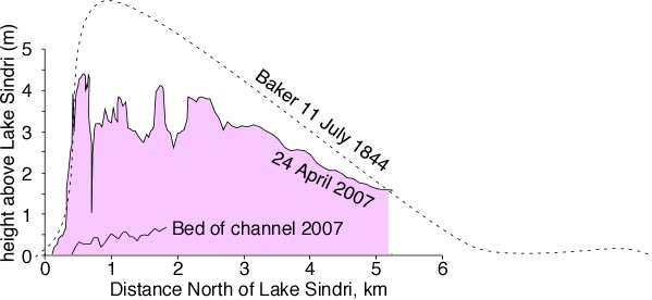
Oldham's discovery of Baker's 1844 map in 1898, was actually the discovery of a tracing of the original map. It is probable that this tracing was made by Wynne from the original map prepared by Baker [3] for Lord Napier (the governor of Sinde) which is now lost but is discussed on pages 41-43 of Wynne's 1872 Memoir (published in 1873), and by Yule and Maclagan[1882] who were both colleagues of Baker. Oldham published a reduced copy of the tracing which was itself redrafted by the Montessus de Ballore in 1923 [published posthumously in 1924 with a x2 scale error in the vertical ordinates]. Subsequent writers have questioned the accuracy of the amplitude of the Bund shown in Oldham's copy of the tracing, but there seems no justification for doing this given the specific numerical agreement between his section and the stated relief in Wynne's 1872 and Baker's 1846 text, with the current gradient of the Indus Delta, and with the relatively precise correspondence between his map and present-day satellite imagery.
[1] A brief bibliography of Capt. James MacMurdo, the British Resident at the time of the 1819 earthquake (who died of cholera one year later at the age of 35), will be found in Ghosh[1972]. MacMurdo spoke Gujerati and Katchi in addition to Hindi and Persian, and was by all accounts greatly admired by the villagers for whom he was responsible. Much of his work on the history and customs of the area was published posthumously. A mausoleum was erected by his friends to his memory near the spot on the edge of the Rann of Kachchh where, late in the afternoon of 28 April 1820, knowing he would not survive another day, he requested to be buried. The tomb survived the Bhuj 2001 earthquake with minor damage.
[2]Alexander Burnes was assassinated in Kabul in 1842 while attempting to negotiate with Afghan warring chiefs. Shortly after his assassination a major earthquake occurred near Kabul with numerous aftershocks that were described vividly in the diary of Lady Sale who was held in captivity at the time.
[3] See section onWilliam Baker