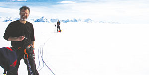
 Ted Scambos (front) and Martin Truffer stand on the Scar Inlet Ice Shelf, a remnant piece of the Larsen B Ice Shelf. Scambos and Truffer (and Erin Pettit, not shown) are conducting a radar survey of the shelf to determine its thickness, using GPS to measure flow speed.
satellite telephone uplinks.
Scambos hopes the field-based studies will give insight not only into the causes of ice sheet breakups, but into threshold conditions for break-ups. With this greater understanding, scientists could forecast what areas of the Antarctic might be close to a big change in terms of ice stability and what the regional environmental implications of the disintegration might be, he said.
The ground-based instrumentation has already added to scientists' understanding of the system, Scambos said. The temperature sensors have shown that there is no specific melt season and frozen season. "A melt can happen at any time of the year," he said. Also, the observations show that the temperature of the remaining ice sheet is now within the range at which most ice sheets break up. "Sometime in the next decade, it will disintegrate."![]()
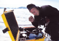
Martin Truffer checks radar profile data of the ice sheet on Leppard Glacier, Antarctica. Radar profiles of the ice thickness will be repeated to look for changes in the ice.
faster than they had been prior to the breakup. The glaciers also began to thin rapidly and the remnant Larsen ice shelf, called the 'Scar Inlet Shelf', showed the same surface melting and cracking that preceded the main Larsen B breakup.
"This promises to be a great natural experiment," Scambos said. "If we can get more data on the remnant shelf and its feeder glaciers, then we'll really get some insight into the causes and effects of ice shelf disintegration."
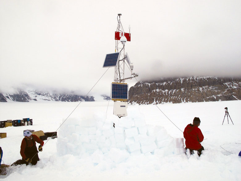
Monitoring the region by satellite alone, however, doesn't give the whole story, Scambos said. To get a closer view, Scambos and NSIDC researchers Rob Bauer and Terry Haran travelled to the Antarctic Peninsula in December 2009 and in three months set up field-based monitoring systems. The systems, called automated meteorology-ice-geophysics systems (AMIGOS), were equipped with weather instruments, GPS units, and cameras and were stationed on the remaining ice sheet and a nearby glacier. Since their installation, they have transmitted data and photographs back to the scientists through
After the breakup
Ground-based instruments in the Antarctic Peninsula shed light on ice sheet collapse
When a chunk of ice larger than Rhode Island broke off the Antarctic Larsen Ice Shelf and crumbled into the ocean below, in 2002, even experienced glaciologists were surprised.
"We simply didn't know an ice sheet could do that," said glaciologist Ted Scambos of CIRES' National Snow and Ice Data Center (NSIDC). "Not just break up, but collapse into a pile of rubble — that was a stunner."
Scambos and other scientists immediately began to monitor the impacts of the ice sheet collapse on the surrounding Larson B breakup region by satellite, as part of the National Science Foundation-funded Larsen Ice Shelf System, Antarctica (LARISSA) Project. They found neighboring glaciers began to accelerate at once, and within a year were moving six to ten times