
A bird's-eye perspective on the planet
Is the same true in other
research disciplines?
Remote-sensing observations from space also tell us how healthy forests are and what kinds of vegetation or land cover types exist. We can track urban sprawl, the movement of population types from one place to the other, and the genesis and decay and the intervening trajectory of hurricanes, for example. All these observations have very real world applications to weather, to longer-term climate, and to the distribution and behavior of life on Earth.
What other challenges face the remote-sensing community right now?
The challenge facing the scientific community right now is really the loss or reduction of our assets in space. Of the 14 NASA Earth-observing system satellites launched over the last decade that are still operating, 13 are past their expected design lives.
The Earth is changing in remarkable and dramatic ways that will affect our lives. Just as we are realizing how and why these changes are occurring, our technical ability to observe and understand them is diminishing. Frankly our success, in the future, as a society is intimately linked to our ability to anticipate what is coming. That ability is becoming compromised at a time when we need it most. ![]()
Can you explain why it is so important to use remote sensing for looking at the Earth's environment?
Remote sensing is observing a medium or a process without ever coming in direct contact with that phenomenon. When you are looking from space, when you are looking from 400-500 miles away, or in some cases thousands or twenty thousand miles away, you get a really different perspective.
We can use remote sensing to better understand our planet as a system, which without the context, perspective, and the scale of observations that remote sensing provides, is really very difficult, if not impossible.
How has remote sensing informed your research?
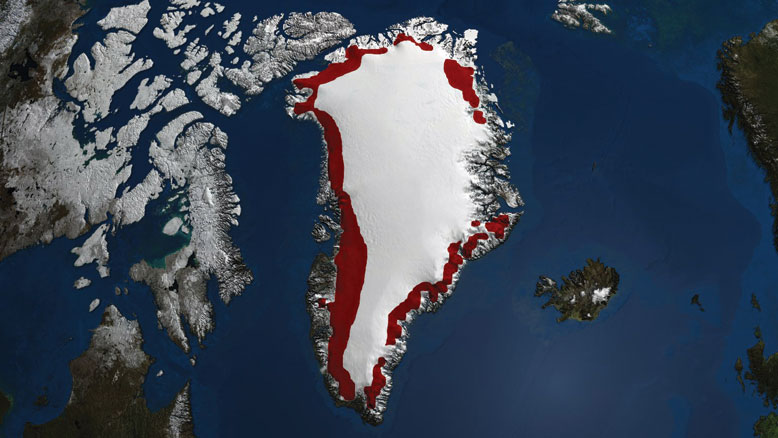
In my own discipline of understanding ice cover, I think remote sensing has literally rewritten the textbooks of how ice behaves and how it changes. For example, just by watching, taking pictures from space, we have been able to observe very, very rapid changes in Greenland and Antarctic ice cover. We used to think the enormous ice sheets responded slowly to climate, and that is only partially true. We are still seeing the effects of climate change thousands and thousands of years ago being expressed in today's ice cover, but what remote sensing has revealed is that there are also changes on the scales of hours and days. These big ice beasts are not sluggish at all; they are very dynamic, very active.
 When it comes to looking at changes in
glaciers and sea ice, Waleed Abdalati, Director
of the CIRES Earth Science and Observation
Center (ESOC) doesn't just visit the Earth's chillier regions, he uses satellites to inform his research. Abdalati believes these satellite and airborne remote-sensing technologies are essential to understanding and anticipating how the Earth, and its climate, are changing. In particular, he has used satellite data in his research on understanding glaciers and ice sheets. The process of looking at Earth using satellite and aerial data is termed remote sensing.
When it comes to looking at changes in
glaciers and sea ice, Waleed Abdalati, Director
of the CIRES Earth Science and Observation
Center (ESOC) doesn't just visit the Earth's chillier regions, he uses satellites to inform his research. Abdalati believes these satellite and airborne remote-sensing technologies are essential to understanding and anticipating how the Earth, and its climate, are changing. In particular, he has used satellite data in his research on understanding glaciers and ice sheets. The process of looking at Earth using satellite and aerial data is termed remote sensing.
NASA appointment
NASA Administrator Charles F. Bolden selected CIRES Fellow Waleed Abdalati to serve as NASA's "Chief Scientist" starting in January 2011. During his two-year appointment with NASA, Abdalati will advocate for the agency's science while retaining his faculty appointment at CU-Boulder.