
Not forgotten
CIRES scientists extract sea-ice data from aging records
The window of opportunity for recovering the old data was closing rapidly. Only the third-generation copy of the digital infrared data still existed along with a single copy of the Nimbus visible light films. In addition, the original Nimbus researchers were now in their late '70s and '80s, and contact with them would be critical to answering some instrumentation questions. These recovered data could be valuable to other Earth science researchers as well.
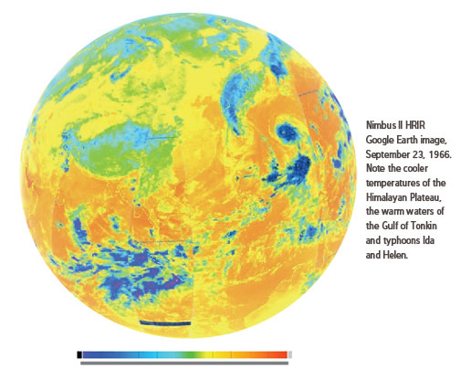
Meier and Gallaher worked with Dennis Wingo at NASA's Lunar Orbiter Image Recovery Project to read and reprocess old Nimbus satellite images, removing errors resulting from the limits of the original processing. Wingo and his staff are experienced in reprocessing old digital data, having recently recovered stunning lunar images from the 1960s. The team finally managed to extract a global infrared image, captured in late September of 1966, at higher resolution than seen before. That's the time of year when Arctic sea ice would normally have been reaching its end-of-season minimum extent.
Much work remains: the researchers seek to reprocess 5000+ Nimbus I, II, and III half-orbit records, develop post-processing algorithms to improve quality, and will then need to painstakingly compare images to separate clouds from ice.
NOAA's Climate Data Modernization Program may get involved in scanning the 200,000+ visible light images acquired by the early Nimbus missions, which are vital, along with the infrared data, in determining sea ice extent.
It could be well worth it: Success extracting the polar monthly sea ice extents for the years 1962-1978 (from Nimbus and other satellite data) would mean adding 16 years of data to a critical climate dataset of 32 years, today — an extension of 50 percent.
Story courtesy of NSIDC.![]()
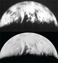
Original (top) and reprocessed (bottom) images of Earth. NASA
But in 2007, John Moses at the NASA Goddard Earth Science Data and Information Service began recovery of 45-year-old digital satellite data from the Nimbus Polar orbiter. NSIDC scientist Walt Meier and project manager David Gallaher heard about the work, and they wondered if this early NASA satellite data might also yield information about sea ice conditions before 1979.
Scientists today who study polar sea ice conditions rely on satellite records reaching back to 1979. But CIRES researchers in the National Snow and Ice Data Center (NSIDC) are learning to extend their understanding of Earth's poles by sifting through some of the oldest Earth-observing satellite data for new information.
"This irreplaceable data has relevance to climate change and should be saved as a part of the climate data record," the NSIDC-led team concluded during an Innovative Research Program (IRP) poster presentation at CIRES in November 2010 (the original research was funded by CIRES' IRP).
When NASA launched the Nimbus satellites in the 1960s, primarily to make twice daily, global, meteorological observations, no methods existed to detect features such as the margins of the sea ice cover in the Arctic and Antarctic. Computer processing power was too weak to support much experimentation.