Highfliers
Three decades of aircraft-aided atmospheric research at CIRES
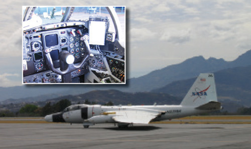
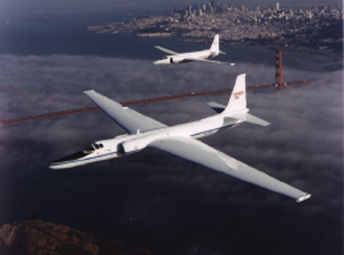
When a one-seat, one-pilot “Gary Powers spy plane” flew directly into the Antarctic ozone hole in 1987, it didn’t just clarify one of the decade’s most important scientific mysteries—it also cemented the value of aircraft missions in the ever-evolving field of atmospheric science.
“A lot of our research productivity over the last few decades is intimately tied to being able to put instruments on airplanes and take those airplanes to interesting places,” said CIRES Fellow David Fahey, who has been an atmospheric scientist at NOAA since 1979.
Only two years earlier than the 1987 flight, scientists had alerted the international community that a hole in the ozone layer had appeared over the Antarctic; this is the layer of gas that shields Earth from the sun’s harmful ultraviolet radiation. But while scientists didn’t dispute the findings, controversy prevailed over what exactly had caused this hole to develop and, more importantly, what to do about it.
Enter the National Aeronautics and Space Administration (NASA) ER-2 aircraft and an international team of scientists determined to—in the words of “Star Trek”—“boldly go where no man has gone before” as part of the Airborne Antarctic Ozone Experiment (AAOE).
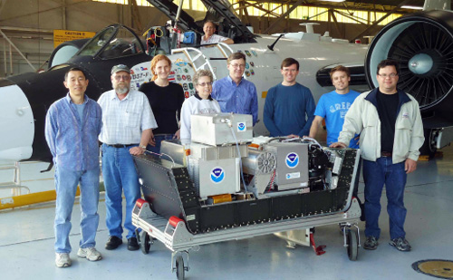
The AAOE team, which included Fahey, fitted the plane with 12 instruments designed to measure key atmospheric variables. The aircraft, which was typically used for military reconnaissance missions thanks to its ability to fly at high altitudes, would take off at
8 a.m. and return late each afternoon laden with observational data. “There was no other way of obtaining that information in those times,” Fahey said.
After months of carefully inspecting the data, the scientists could determine exactly the culprits behind the hole: Chemicals such as chlorofluorocarbons (CFCs), which were increasingly being used for refrigeration, air conditioning, foam blowing, and industrial cleaning, were depleting the ozone layer, stripping the planet of its “protective sunscreen.”
At an international meeting in Canada in 1987, the Montreal Protocol on Substances that Deplete the Ozone Layer was adopted. With results from the AAOE mission and subsequent studies, this protocol laid the foundation for the subsequent recovery of the ozone hole, which current models predict will now recover completely by the year 2050.
“To have an aircraft program provide such a pivotal contribution at the crux of what the world is trying to understand,” Fahey said, “that was a big prize for aircraft missions.”
Aircraft adventures
After the important role the NASA ER-2 played in understanding ozone layer depletion, atmospheric scientists expanded their use of aircraft missions to investigate all manner of scientific problems. Airplanes can carry instruments designed to measure the atmosphere’s key gases as well as its aerosols—tiny airborne particles that can cause severe health problems and also affect climate.
Airborne research complements other techniques scientists use to understand the atmosphere, such as satellites and ground-based measurements. While airborne missions have their disadvantages in terms of the required manpower and finances, they also have unique advantages, Fahey said.
“There are things that aircraft can see that satellites can’t see,” Fahey said. “And satellites can’t see the things they do see with the same kind of accuracy and comprehensiveness that a well-designed aircraft mission can.”
While aircraft missions have also contributed to understanding the troposphere—the layer stretching out from Earth’s surface to approximately 8 to 17 kilometers (5 to 10 miles) depending on latitude—the largest fraction of
Fahey’s aircraft-assisted research has focused on the lower stratosphere—the layer stretching from the top of the troposphere to approximately 20 kilometers (12.5 miles). Following his early research on the ozone hole, he took part in airborne missions in both the Arctic and the Antarctic to study atmospheric processes that control ozone amounts. “During that time, we came away with a lot of prizes in terms of understanding key atmospheric processes in more detail,” Fahey said.
One of those prizes was made during the last NASA ER-2 campaign to study ozone depletion when Fahey’s research group discovered a new class of polar stratospheric cloud particles by using a gas phase instrument developed by his group. “There was no expectation within the community that that class of particles could exist, and here we stumbled upon it,” Fahey said.
The discovery illuminated a missing piece of the ozone hole puzzle—in particular, a key mechanism that enhances ozone depletion in the Arctic as well as the Antarctic. “It really helped connect the dots in terms of allowing the community to much more quantitatively simulate what they see going on with ozone,” Fahey said.
These particles were invisible at the time to other techniques used to study the stratosphere, providing yet another example of how airborne missions are invaluable to the field of atmospheric science, Fahey said.
From ozone to climate
More recently Fahey and his team were involved in the HIPPO (HIAPER Pole-to-Pole Observations) project—the most extensive airborne global sampling of carbon dioxide and other greenhouse gases in the atmosphere to date.
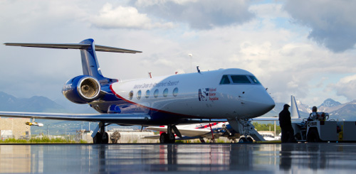
The HIPPO project used the NSF/NCAR Gulfstream V jet aircraft, which housed specialized instruments for measuring atmospheric gases, aerosols, and meteorological parameters that were mounted in pods under the wings or inside the cabin. On five separate missions between January 2009 and January 2011, the plane flew pole to pole between latitudes 67° S to 85° N—roller-coastering continuously from 0.5 kilometers (0.3 miles) to 8.5 kilometers (5.3 miles), while continuously sampling the ambient air.
“When you put all the data together, it looks like what they call in the satellite world ‘a curtain file,’” Fahey said. “We get latitude and height measurements between both ends of the globe.”
Fahey and his team used the mission to study black carbon in the atmosphere. The burning of coal, diesel, biofuel, such as firewood, and biomass (for example, agricultural waste, forests, and grasslands) releases black carbon, a fine particulate that makes up soot. Because these tiny particles penetrate deep into the lungs, long-term exposure can cause chronic bronchitis and asthma, while the organic by-products that often coat the particles may raise cancer risk.
In terms of global climate, black carbon is also an important heat-trapping agent, absorbing solar radiation and affecting cloud formation. “We’re interested in exactly how much there is, where it came from, and what its fate is,” Fahey said.
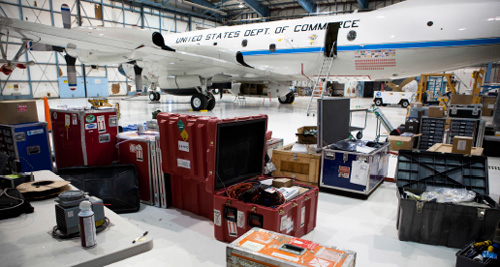
As well as analyzing the high-altitude measurements of black carbon, yielding information about the climate impacts of the particles, Fahey’s team also took lower-elevation measurements on the NOAA WP-3D aircraft, which are more relevant to the air we breathe, in the Los Angeles region. These yielded encouraging results.
Despite a steady increase in the use of diesel in L.A., black carbon concentrations are lower now than in 1965 because of government regulations. “Without such stringent standards, L.A. could have looked more like what you see in the Pearl River Delta in China, where levels are up to 10 times higher,” Fahey said.
“If we know how much black carbon there is, we can ask, ‘How many people are breathing this? Is that bad for them? How bad? Where are the hot spots?’” Fahey said. The work being done by Fahey and other atmospheric scientists will help policy makers decide how to best achieve reductions in the amount of black carbon in the air we breathe, and such work was only possible using airborne research, Fahey said.
Who needs a pilot?
While the role of aircraft data collection in understanding Earth’s atmosphere remains undisputed in the research community, Fahey conjectures the nature of airborne missions will change in future research. In particular, he sees a greater role for unmanned aircraft, or drones.
“Consider the HIPPO project: If you can send out a drone to do that, you wouldn’t have to stop on an island in the South Pacific and give everybody a night to sleep and eat,” Fahey said. “A drone can go and make observations autonomously with humans overseeing in the background.”
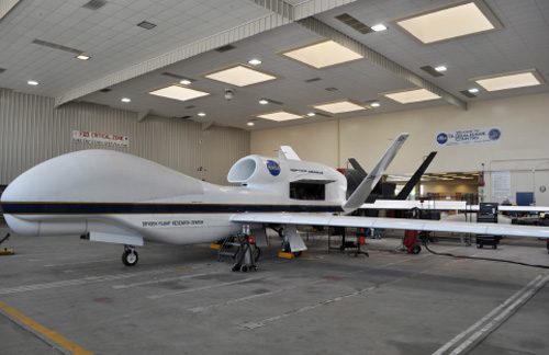
As scientists engineer smaller instrumentation, the range of research aircraft CIRES uses could extend from NOAA’s Global Hawk—a 25,000-pound airplane that can carry 1,000 pounds to unmanned drones that fit in the palm of a hand. “That whole spectrum of airborne technical devices will allow us to explore things in a way that we haven’t explored before,” Fahey said.
Fahey sees drones addressing a basic problem facing atmospheric scientists: the difficulty in obtaining enough measurements over time to adequately characterize the atmosphere—termed the “under-sampling” problem. “We would benefit as an atmospheric science community to have more high-quality data from the atmosphere,” Fahey said. “We have an appetite for that data, but we don’t have a path right now to get to that point.”
Drones may be part of that path, Fahey believes. The cost savings of such unmanned aircraft can immediately be turned back into “Let’s fly some more,” he said. But while drones might help scientists to gather more of the same type of information, hopefully solving the under-sampling problem, they could also enable scientists to measure an entirely different type of data, he said.
“What about flying along with an air parcel for a week or month and making continuous measurements?” Fahey said, momentarily appearing lost in the land of possibility.
Seems like the evolution of aircraft might free imaginations—as well as planes—to soar.

