
Seismic Shake-Up
The technology-inspired evolution of CIRES’s Solid Earth Sciences Division
 Geophysicist Anne Sheehan remembers the days when learning about an earthquake required some serious legwork.
As a graduate student at the Massachusetts Institute of Technology (MIT) in the 1980s, when an earthquake of interest struck, she took the train to Harvard where recordings of Earth surface motions (seismic records) were stored on large tapes. She crammed as many as she could into a backpack and then lugged them back to MIT to analyze the data. “It’s hard to imagine a world before the Internet, but we did get things done,” recalls Sheehan.
That level of effort to acquire earthquake data seems unimaginable in the age of the Internet, says Sheehan, now director of CIRES’s Solid Earth Sciences Division. Nowadays within seconds of a strike anywhere around the globe, a scientist can get an email or text alert or check out the details of the shake from the U.S. Geological Survey’s website. And this advancement has happened in the blink of an eye in geological time scales, where time measurements are frequently made not in decades, or even millennia, but in millions of years.
 CIRES and CU’s seismology program was born in 1967, around the time the theory known as plate tectonics was becoming widely accepted. Plate tectonics revealed that the top 100 or so kilometers of our planet are split into a series of rigid plates, like the cracked shell of an egg. These plates move around due to convection in the underlying mantle, a layer of hot material that can flow like a liquid over geologically long time periods. These plates jostle against each other and temporarily get stuck for tens to hundreds of years until they suddenly break apart, producing earthquakes. Volcanoes are also associated with tectonic plate motions, as magma upwells when plates pull apart or dive down underneath each other.
The plate tectonic theory marked a paradigm shift in the field of geology—geologists suddenly understood the link between the location of volcanoes and earthquakes and could explain why Africa and South America looked suspiciously like they had been ripped apart.
Sheehan came to CIRES in 1993, and she began to explore a number of questions surrounding the nuances of plate tectonics: Is the Rio Grande Rift, a gash that ripped apart North America from Colorado down to Mexico, still active? What does a fault look like miles below Earth’s surface, a place we will never see with our own eyes? Why are the Rocky Mountains thousands of miles from the edge of a plate, when most mountain chains form near the edges, crumpling upwards from the force of the collision?
Technology inspired Sheehan to focus on Colorado when scientists deployed a set of broadband seismometers—instruments that can record a wide range of ground motion—along the state’s Front Range. “The revolution to broadband instruments happened when I was in grad school,” Sheehan said. “They weren’t nearly as portable as they are now, but they 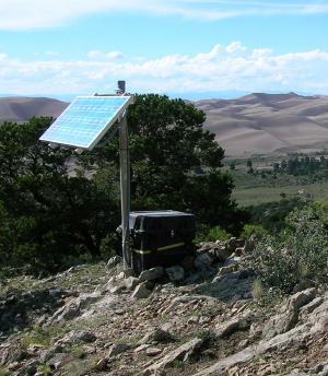 could record a broader range of ground motions without getting cut off by strong shaking.”
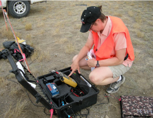
Using the data recorded on these seismometers, Sheehan could identify the large-scale crustal and mantle structures underneath the Rockies, work that formed the basis of her subsequent 20 years of research at CIRES. During that time, Sheehan and her students have continued to use seismometers to image the Rockies, although now they are focusing on finer details using more advanced instruments. “In the early days, we had 30 seismometers. Now we have 42 broadband seismometers, 172 short-period instruments, and 1,800 little Texan seismometers,” she said.
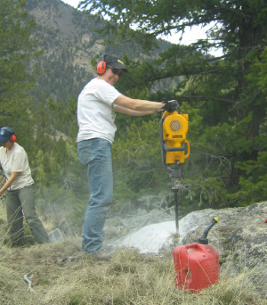
Why so many? Sheehan’s group is conducting both “active” and “passive” source experiments. In an active source experiment, Sheehan creates waves with an explosion rather than waiting for an earthquake to provide its own. A passive experiment involves simply recording the seismic waves when an earthquake strikes anywhere in the world, sending some of its waves to Colorado. A dense array of continuous (collecting data constantly) machines picks up on all the details during an active experiment. The machines for the passive experiments are more widely spaced and collect data less frequently.
Even as Sheehan advances the science of plate tectonics, however, she is quick to point out that her current work rests firmly on the shoulders of CIRES Fellows who came before her. The first two directors of CIRES were both geophysicists. Chris Harrison (director from 1969 to 1972) not only played a prominent role in starting the geophysics program and CIRES at CU, but also laid the groundwork for using global positioning systems (GPS) to study the movement of tectonic plates. The late Carl Kisslinger (director from 1972 to  1979) was a seismologist who recruited top geophysicists such as Bob Engdahl and Hartmut Spetzler, and later hired Sheehan. Engdahl and Kisslinger were responsible for developing one of the first networks of seismometers to record ground motion, which they deployed in Alaska’s Aleutian Islands from 1974 to 1992.
Today, building on Harrison’s early work, Sheehan is using GPS to study motion along the Rio Grande Rift. Her most recent results show that the rift is indeed moving, although at a mere 0.1 millimeters per year—slow even in geologic terms. For Sheehan, though, that just opens up more questions she’s eager to explore, questions that she hopes will lead to a better understanding of how the Rocky Mountains formed.
No matter where her research leads, though, one thing is clear: She won’t have to lug heavy seismic records around.