Creep-meters

Shallow segments of many faults of California slip slowly by a process known as fault creep. Some of these faults are monitored by creep-meters that transmit slip data every 10 minutes to an accuracy of 0.01 mm.

Data

Data from the creepmeters of Central California (red dots) can be accessed graphically on the USGS data access site or downloaded numerically.

Creepmeter data in Southern California (green dots) may be viewed by clicking on the map, or by clicking on the table below right.

Data with 10 minute to 2 hour latency can be accessed at

DataGarrison.com

user geo Password hobo

During the transition to a new data access web site, archived Hayward fault data not yet updated may be found here

Surface Creep?

Fault creep cracks roads and walls, and cuts buried pipes and cables, and in some places passes through structures requiring their periodic repair.

Creep is important in that it releases slip on a fault that would normally be available to drive a future earthquake. The region of the San Andreas fault between San Juan Bautista and Parkfield creeps at almost the full plate velocity and no large earthquake is anticipated. Usually, however, surface creep extends to depths of the order of 1-5 km with the region below this accumulating strain that will drive future earthquakes.

Click on creepmeter of interest to access its data.
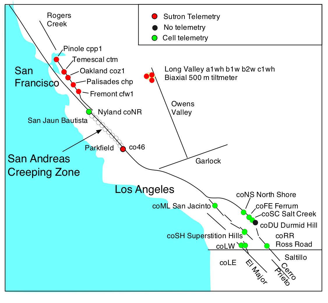
site mm/yr fault lat long location
cpp1 4.9+-0.3 Hayward 37.9892 122. 3545 Pt Pinole
ctm1 3.3+-0.3 Hayward 37.8438 122.2272 Temescal
coz1 3.0+-0.4 Hayward 37.7527 122.1500 Oakland Zoo
chp1 4.7+-0.5 Hayward 37.6627 122.0740 Palisades Road
cfw1 6.6+-0.2 Hayward 37.5323 121.9523 Fremont
coNR 8.7+- 0.5 San Andreas 36.8550 121.5460 Nyland Ranch
co46 3-3.2 San Andreas 35.7429 120.2818 Cholame
coNS 0.4 San Andreas 33.5307 115.9388 NorthShore
coFE 2-3 San Andreas 33.4572 115.8539 Ferrum
coSC 1.5-3 San Andreas 33.4485 115.8437 Salt Creek
coDU 2-3 San Andreas 33.4147 115.7985 Durmid Hill
coSH 0.6-11 Superstition 32.9301 115.7009 Imler
coRR 1.3 Imperial 32.7812 115.4485 Ross Road
coLW 0.4 LagunaSalW 32.6483 115.848 Yuha Desert
coLE 0.2 Laguna SalE 32.6643 115.8790 Yuha Desert
coML 3+-1 San Jacinto 33.8965 117.0866 Mystic Lake

Triggered slip and episodic creep events

Occasionally the slow surface slip of a fault is interrupted by one or more episodic creep-events with amplitudes 1-28 mm. They may also slip abruptly at the time of local earthquakes. In some case rate changes occur as a result of stresses induced by earthquakes on nearby faults.

Although creep invariably follows stress changes applied to a fault, accelerated creep on a surface fault has hitherto not been observed to precede a major earthquake on that fault.