|
.
Today is the last Monday we will be in the backcountry. It is odd to feel like a trip is ending when, in fact, a seven day backpack would seem like a big deal. And yet that is how I feel despite the week of traveling the high country that remains.
Sometime overnight my little brain started to realize that we have made a mistake. My original plan for campsites not only included Twin Lakes, which we bypassed yesterday, but also Rae Lakes, which we must bypass today in order to honor the grazing rules. We have trimmed not one but two days from our schedule. We could have had a nice short day yesterday and another fairly short day today. Rats. So I start thinking, is there a good place to spend an extra day on the rest of our route? We cannot stop before the far end of Vidette Meadow today unless we divert off to Charlotte Lake, where we can graze below the far end of the lake. From Vidette to Forester Pass we could stop and camp and break up the long haul to the pass, but in point of fact there aren't a bunch of great campsites along that stretch of trail. I play with visiting Lake South America, but that would require two days. From a camp on the far side of Forester it makes little sense to stop before Crabtree Meadow. About the best way to use that extra day is to have a layover in Rock Creek's drainage. The problem there is, in part, that when you get that close to leaving after a long trip, it is hard to not look forward to getting out. I kick myself for passing up the chance to explore around Twin Lakes, an area I had never visited and probably no will never get a chance to explore. Shoot. Megan and I will have to consider our options.
After yesterday's morning light show, sunrise today seems pretty subdued. I do get a view of light reaching the peaks on the north side of Woods Creek back down the canyon, but otherwise I am hoping for the warmth of the sun finally reaching us. Breakfast includes the egg mix again this morning. I fish out foil from the fire, not only mine but some other foil from earlier residents of this camp. This time sleeping out worked OK; it was a bit chilly, but everything stayed dry, so packing up can be done right away.
When I am decanting some water for the day's hike, I find little bits of black plastic in the water. I now am recalling smashing the water filter at Wanda Lake and I am wondering if I damaged it somehow. We have a spare filter, so I go ahead and install that and examine the old filter. I can see no way for water to bypass the filter, and the filter itself seems OK, so probably we haven't been drinking unfiltered water, but that possibility will lurk in the back of my mind for the couple weeks it takes for giardiasis to show up. Perhaps all of this explains my oversight when we leave camp: the Sierra cup I had is left behind; I'll have to steal one of the plastic drinking cups to use for filling my water bottle prior to using the UV filter.
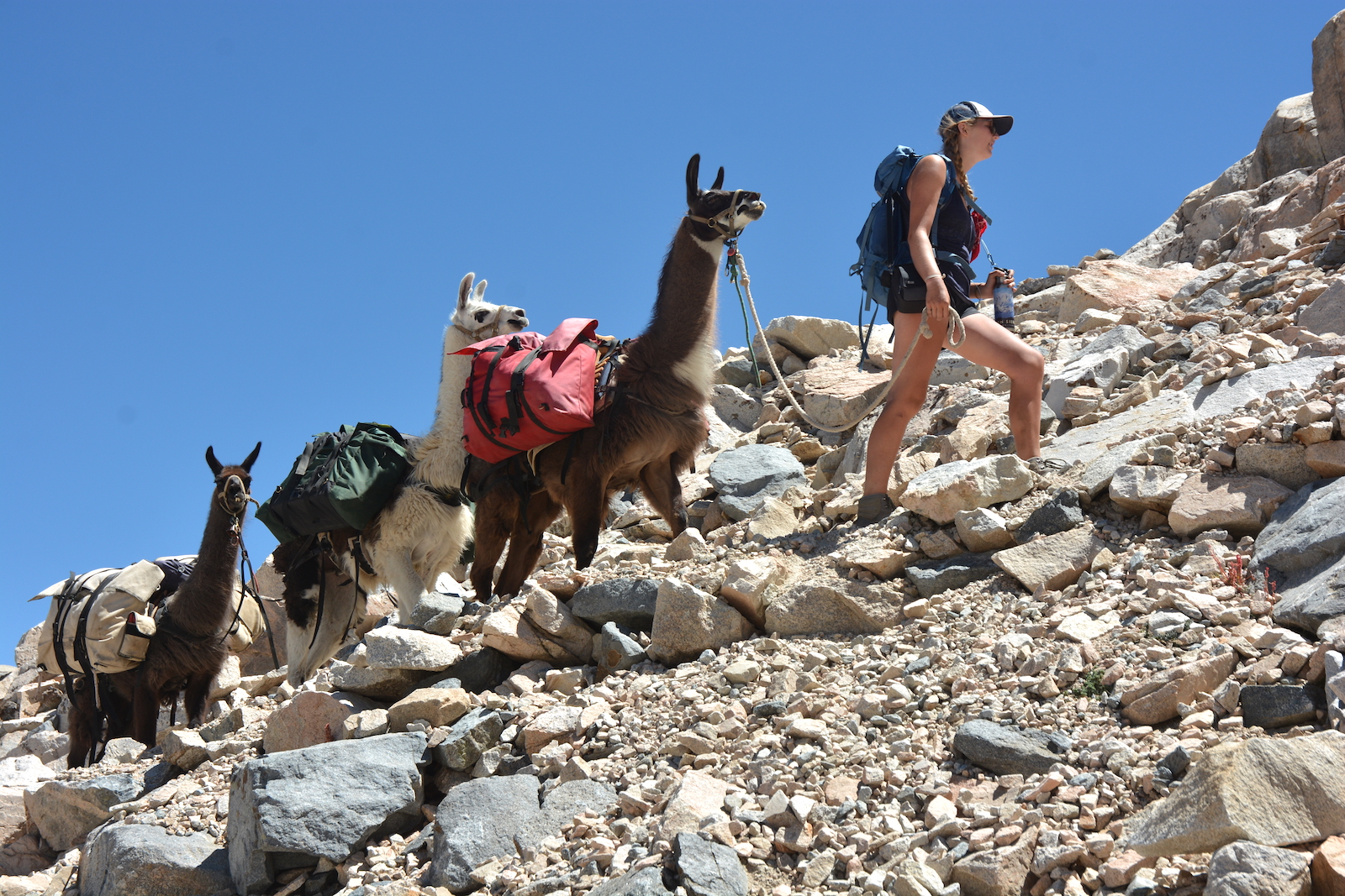
All of the shenanigans with the water delays our departure until 9:40 am, when we pull onto the nearby trail right in front of a couple of backpackers. At least we knocked out 1000' of our climb yesterday so there is only 2600' of uphill instead of 3600'.
As we rise up, it dawns on me that I probably have not traveled this portion of the Muir Trail before despite having done the Rae Lakes Loop. When we hiked it long ago, we went into Sixty Lakes Basin to the west from Rae Lakes and then exited near our present position. So it is another piece of new trail for me. As the trees thin, we look back to the north and see a couple of peaks that were hidden from Pinchot Pass: Pyramid Peak and Window Peak are settled back of a south-draining complement to the South Fork valley we are looking down. Soon enough our attention turns to the vistas before us as Fin Dome begins to appear on the horizon, and then we are at Dollar Lake, the lowest of the Rae Lakes Basin, and at the junction with the Baxter Pass trail.
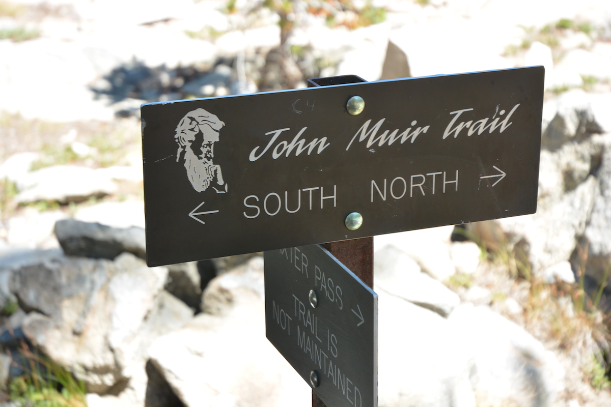 The sign here reminds me of many other signs we've seen along the trail. Formerly, trail signs would tell you about a destination on that trail and a distance to that destination. Apparently somebody decided that information like that wasn't really necessary any more, but all we really need to know is that this is the John Muir Trail and which way is north and south. Seeing as you really shouldn't be in the backcountry if you don't know north from south (and at this spot there is no ambiguity), it seems that the purpose of trail signs has changed from guiding hikers to just being pieces of scenery. Or maybe the Park Service got a sweet deal on a bunch of generic Muir Trail signs....
Anyways, with the tops of peaks like Painted Lady and Dragon Peak starting to show themselves above Dollar Lake, we know our trail will relent its upward trajectory for awhile. We pass Arrowhead Lake and wander through some meadows before the trail levels off at the lowest of the three Rae Lakes. The breeze ripples the lake enough to produce a strong blue color in the lake. Our trail wanders up and down over small bedrock ridges projecting into the lake, providing occasional views over the lake which alternate with passages through the forest. Foxtail pines, soon to be a major part of the Sierran forest as we continue, make an appearance, their insistence of remaining upright no matter their location helping to make them stand out.
We've noticed that the many hikers we meet are largely a different group than we had been seeing before we hit the Woods Creek Junction. While there are some long distance hikers mixed in, many if not most of the folks who we chat with about llamas are people in for a few days, perhaps doing the Rae Lakes loop or coming for an in-and-out trip over Kearsarge Pass, the last relatively easy access to the Muir Trail. When we get to the middle Rae Lake I see the ranger cabin nestled on a knob to our left, its rear festooned with laundry lines and radio wires. Although Bob the ranger encouraged me to have a look, I decide that we might as well continue as we won't be staying anywhere near here. Luck would have it, though, that the ranger is on the trail a short distance in front of us. Some friends of his had come in to bring him some pleasant foods, and he is, it seems, showing them around a little. So we end up chatting anyways.
Although part of the conversation involves confirming the grazing restrictions, we do pick up some other information. The Baxter Creek drift fence meadow was pounded down because a packer had lost a couple of animals here; they had made it over Glen Pass to Charlotte Lake and he had to go back and recapture them, leaving the bulk of his animals at the meadow for a few days. The ranger thinks it might be time to close that meadow, which would be a blow to any later stock parties who would be stuck crossing this stretch of the trail from north of Woods Creek all the way past Vidette Meadow, an even longer stretch than we were doing. We also learn that the Charlotte Lake ranger is out for a few days; the Rae Lakes ranger suggests that we can use her administrative meadow by the ranger station if we want. I decline, figuring we are wanting to continue on the trail. But I did mention our sort of odd dilemma in looking for a good use of a spare day. I mention that Bob had suggested we tour this cabin, and the ranger offers to take us back up, but it doesn't seem worth it with the llamas and everything. The ranger does say it is a nice cabin, but that unlike the rebuilt one at LeConte, this one has mice problems. He said he came in after one winter and the place was a total disaster with some animal having lived in the cabin through the winter. I am a bit puzzled about the pipe chimney and the stove he evidently has: as wood fires are prohibited anywhere near Rae Lakes, where does he get wood? He said that they send in commercial pressed sawdust logs with other supplies; he doesn't burn local vegetation.
We only go a little farther to where the trail crosses the connection between the uppermost and middle Rae Lakes, stopping on the east side to eat our lunch (Megan is in favor of continuing, but I argue for stopping here). We discuss what to do with the spare day I had realized we now had. We look at the map some; nothing really jumps out. Our best use would probably be in the Rock Creek drainage, but there are grazing rules there that are pretty bizarre. It doesn't help that we don't have nearly as good a map for that area as the rest of the trail, I having neglected to bring my old Whitney Quad guidebook or a newer Sequoia-Kings Canyon map.
While we eat, a small group parks themselves just on the other side of the short stream separating the lakes, and they pull out fishing rods. One fellow is clearly a pretty accomplished fly fisherman; he promptly pulls in a fish, decides it is too small, and returns it before pulling in another fish that he considers keeping for dinner. A second fellow soon unlimbers his rod and tries his luck, which isn't quite as good.
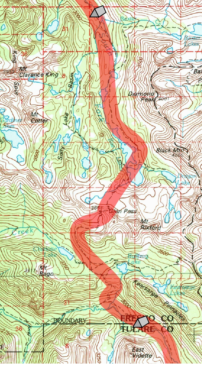
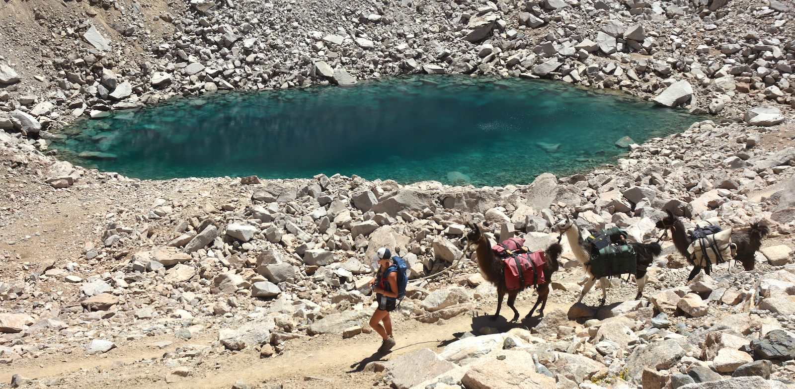
When we finish, it is time to tackle Glen Pass. We cross the creek, passing by the fishing group and exchanging a brief few words before beginning our climb to the pass. The trail quickly switchbacks tightly up the side of the cirque holding the lakes, finally cresting for a bit on a bench between the cirque top and the pass. A few rock-bound lakes are scattered along this bench. Off to the west I marvel at the grade of some glacial moraines rising above us. Our time on the bench is short, and we are soon puffing up the switchbacks to the summit (well, I am puffing; Megan seems little fazed by the grade). This pass has a summit narrower than the others we have visited, but there is a small flat off the trail where we park the llamas for a bit while we snap some pictures and have a bit of a snack. Pass number three is now conquered.
Unfortunately that is just over half of our total journey and it is now 2 pm. We resume our descent. The view south is limited by a ridgeline a little to the south, hiding much of the Kings Kern Divide and pretty nearly all the Sierran crest to our south; only the north end of the Great Western Divide, anchored by the classic lines of Mt. Brewer, has been clearly visible. Now even the little that had been visible quickly drops behind the rock wall towards which we are now descending. Skirting well above a rock-bound, typically inky-blue lake, the trail switches back down above a lower and more startlingly colored lake. Its very light blue color is reminiscent of glacial lakes, but there is no glacier and the lake is far clearer than lakes with glacial flour. Its color leaves me a bit baffled; maybe some small amount of glacial flour is coming from a rock glacier hidden under the debris to the south?
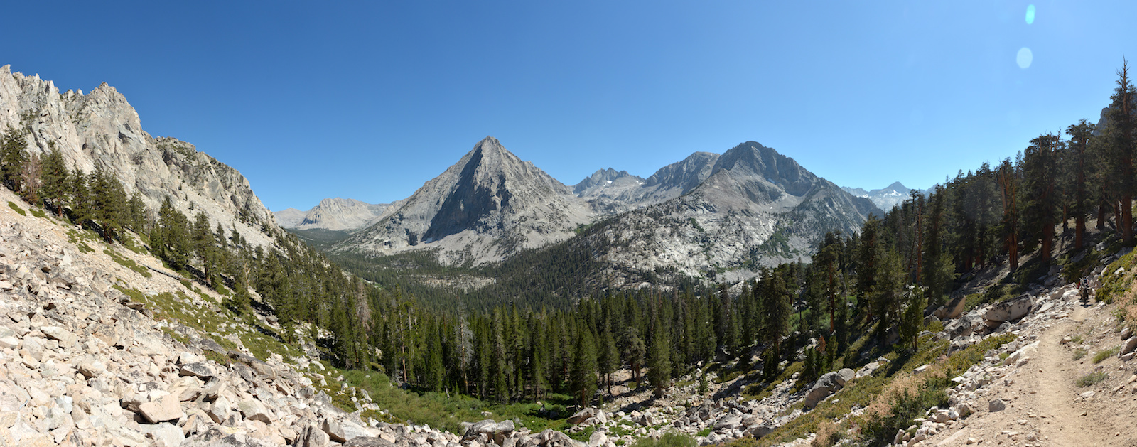
We are now pretty intent on making it to camp. We have to descend to Vidette Meadow and then climb to the southern edge of the meadow termed Upper Vidette Meadow. The trail now detours around the rock wall to our south, carrying us to the west and then around the west flank of that rock wall. Views now open up; we get an excellent view of Charlotte Dome down the Charlotte Creek drainage, and much of the lake comes into view as we contour far above it. Oddly to our eyes, campsites seem common just below the trail; we cannot see where campers would get water. I wonder if these are mainly used by early season PCT hikers who can get water from melting snow; nestling up as close to the pass as possible might make sense so that they could hit a snow-covered pass early in the morning when the footing would be firm. Looking at the lake, I question my dismissal of the offer of the meadow at Charlotte Lake: a camp here would be made sooner, there would be a lake for Megan to swim in, and we could simply make tomorrow an easy day getting close to the base of Forester Pass. When we finally reach the junction with the Charlotte Lake trail I stop Megan and suggest that we could do that option. She is pretty intent though on getting in position to cross Forester tomorrow and isn't interested in a 1-2 mile detour off our main route. So we continue on the flat glacial till along the divide between Charlotte Creek and Bullfrog Lake, passing multiple trails heading left towards Kearsarge Pass.
Soon we are plunging down through an open forest with the creek draining the Kearsarge Lakes at our side. The trail pops out across a talus slope giving us a spectacular view of East Vidette and the peaks beyond as well as a bit of a preview of the Bubbs Creek valley we will travel tomorrow. East Vidette is a bulky triangle with a large rib projecting towards us; unlike other peaks with parts gouged out by glaciers to look like molars, this thing resembles a canine jutting up from the flats near Vidette Meadow, the narrow avalanche chute on the prow facing us almost a challenging scar on a boxer's face.
We drop back into the forest and the views get less and less frequent as we turn back and forth. Finally the trail drops to the valley floor and we turn left to rise once more, spurning the branch heading downhill towards Roads End. A large campsite is nearby and has several tired hikers. We still have to march a ways until we can rest. Signs on the trail say that there is no grazing until after the drift fence above Upper Vidette Meadow, but I have the grazing rules with me and they say that private parties like us can use Upper Vidette. I want to go no farther than we have to.
We pass the meadow, the trail rises some, and there is another part of the meadow, but this is not our part. The trail now veers away from the creek and rises more rapidly, aiming to gain some glacial steps above us. We rise up on top and things are flat for a bit; I go and look to the side for a camp but find only that the creek is far below us, boiling in a narrow notch. We must continue farther, though I am now sure we are in what the grazing map shows as Upper Vidette Meadow. After another, shorter climb we see some flats to the right and a trail of use heading that way. A quick jaunt along that trail reveals a campsite with some grass nearby. Megan is not sure this is a very good site, so she heads ahead once more, descending to near the creek. She returns with the news that the packer campsite mentioned in the grazing guide is below us; it has a nice firering and isn't too far from water. It turns out our trail of use in fact descends to the campsite. With an open area on one side and forest on the other, it is a pleasant spot. We are both grateful to be done for the day; we are past 4:30 in the afternoon and feel that we've had a pretty good day.
Although the grasses are not widespread, there are some more verdant patches and soon we have the llamas strung out through some of that. Megan gets her tent up and heads to the water to clean up; I plan on sleeping out again, so I worry more about organizing things for dinner. This is our last camp under 10,000' and so the last place where we can have a fire, so we collect some firewood so we can enjoy that luxury. We are aware of a couple of campers back up near the trail; Megan noticed them when we headed down towards the creek. But we cannot see or hear any other campers, so it is our fourth straight night of solitude in camp. We eat well at dinner, enjoy the fire, me longer than Megan, and are off to bed. Tomorrow we face the highest of our passes, Forester. Once across that, we will certainly be heading out to Horseshoe Meadows. I send an email from our YB device to Greg: we understood you would be at Horseshoe on the 13th, could we come out a day early? Even though we haven't decided, Megan's eagerness to return to see high school friends before they part for college suggests that getting out early may be the smart thing to do.
Day 17. 6.5 mi camp to Glen Pass, 3.9 Bubbs Creek Jct, 1.2 mi. Upper Vidette Meadow; 9470' Baxter Creek Drift Fence Meadow, 12,010' Glen Pass, 9520' Bubbs Creek Jct, 9870' Upper Vidette Meadow.
11.6 miles, 400' net elevation gain, 2970' total elevation gain
Total to this point: 154.7 miles traveled, 29,490' total elevation gain.
prep | 0 | 1 | 2 | 3 | 4 | 5 | 6 | 7 | 8 | 9 |10 | 11 | 12 | 13 | 14 | 15 | 16 | 17 | 18 | 19 | 20 | 21 | 22 | coda | CHJ home