|
 The trail out of the Quail Meadows area is a first taste of the steep uphills the southern Muir Trail will bring. The trail rises more than 2000' in a horizontal mile, a bit over two trail miles, only to lose half that gain in dropping to Bear Creek. It is a somewhat intimidating first day for Matt to travel with us. In any event, we want to get over the steep part as soon as possible so we aren't hiking in too much heat.
I am up early, as usual, but then so is Megan, rising about 7 am to help get the day going. Despite being at the bottom of a fairly deep canyon, the sun actually hits camp about the time Megan starts getting up. Matt decides that his shoes are worth risking on the hike, so we have to plan on how much of his gear we can carry. We are a bit conservative in this, not wanting overloaded llamas on this big uphill, though we do have all the food and a few of Matt's heavier items. As Megan and I go through the process of packing and loading the llamas, we release Matt to head up the trail first. He rather expects we will catch him quickly. We finally hit the trail about 9:45 am, a decent time for us.
The area around us is quite busy, which in a way is a surprise because many hikers head down to Vermilion Valley Resort for a resupply or to make purchases in their store. And so as we are heading up we get the usual requests for photos of llamas and a few questions, but farther up there are fewer hikers and we are largely left to labor alone.
This segment of trail is another where our traveling to the south benefits us: the trail is on a shaded, north-facing slope. Even so, the grade is fairly steep. Megan, as usual, keeps a steady and fairly brisk pace going up; the couple of occasions where I stop for a photo requires me to work hard to catch up. In a way, then, the absence of any really compelling views is also a benefit. At one point there is a tree across the trail; the first two llamas cross it and start to continue, but Joe in the rear fails to cross and gets jammed up against the tree. I come forward to release the panic latch and guide him around before reconnecting him to Theo. Joe clearly prefers to be in front.
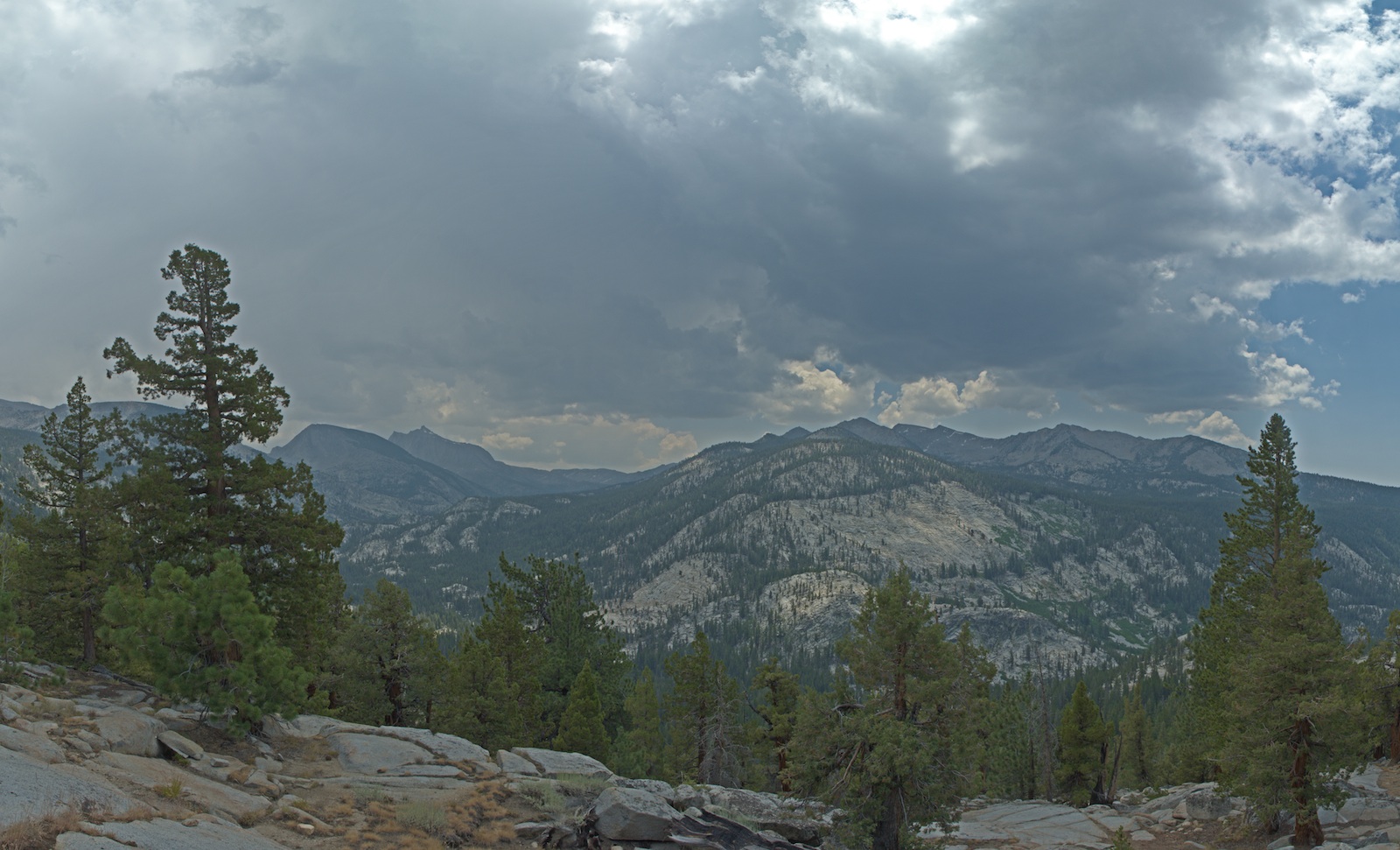
Despite being on a steep slope, we have nearly no views; the forest is too thick. I take one quick detour to a knob that maybe has a view out to Lake Edison, but the view west is blocked. I do see the Vermilion Cliffs across the way, though. Only at one spot on the trail to I spy a little bit of the blue of the lake peeking through the trees. We do finally hit a gap in the trees up high where we can look back at the Silver Divide and, it seems, Silver Pass.
On the way up I notice cobbles of volcanic rock. At first I think these were deposited by the glacier that had groomed the 2000' climb, but they increase as we climb. When I look at the geologic map (I put scanned versions of the geologic maps on Maplets and downloaded them to my phone and iPad) I see we pass under a point marked "Volcanic Knob". The rocks are from an eruption 3.5 million years ago of olivine basalt, one of the eruptions with peculiar isotopic compositions suggesting it was created as the bottom fell off Sierran lithosphere. When we start to cross the ridge I get a decent look at some of these rocks, and I verify that there are indeed olivine crystals visible in the frozen lava.
Matt and I had agreed to meet at the large switchback at the summit of the climb, and as we continue to rise with no sign of him, I begin to think that will be our meeting point. But the top of the grade arrives almost imperceptibly; the last bit of the climb is at such a low grade that it is hard to pick out where the trail tops out. Since the trail is pretty distinct, we simply continue on, and at the junction with the Bear Ridge trail we find Matt. He's pleased to have made it up before us, though he says he only just got to this point. There are flies and mosquitoes here enough to encourage us to continue; Matt says he'll be along in a moment.
The trail now begins its serious drop to Bear Creek. Passing through an aspen grove and over a small stream, Megan and I find a nice open spot with a view and a breeze and decide to stop there for lunch. Soon Matt is down with us as we look south towards Selden Pass. We can see the gray veil of rain or hail at the south end of the Bear Creek Valley, which is more or less our destination. But we aren't sure where we will find a camp, so once we are done eating we resume the descent. Watching a cloud build over us encourages us to put the tarps over the panniers.
At the bottom of the grade we find the creek merrily crashing over rock ledges and a junction with the Bear Creek trail, which is yet another way back towards Vermilion Valley. We turn left and don't really dally; we are back in the forest now and the flies are a major nuisance. At one point when Matt catches up, he notes that he can follow us by the trail of dead flies. So although the valley is picturesque and offers a number of swimming holes, we push on.
There are supposed to be a lot of campsites along this section of Bear Creek, but it is early enough that we want to continue to push on. We pass the old trail to Lake Italy, a spot I long ago had hoped to visit. At least I'm able to see the peak of Seven Gables, which I had heard of over the years as well. We now are in the upper part of Bear Creek's valley and plan on camping before the trail fords Bear Creek and heads up towards Marie Lake; this stretch though is a bit more barren of campsites. Megan and I start serious scouting, but sites we find are not terribly good, either lacking in grass or just marginal sites. We do find what looks to be an old segment of the Muir Trail that followed the stream more closely. We might well have spent more time here looking than any other camp on this trip. We find a small campsite on a granite rise, and we think it might work well enough so Megan guards it against any of the other hikers passing by while I double back to get the llamas and Matt. By the time I return, though, Megan has found the site has a swamp behind it and so is unusually buggy; she thinks there might be sites a bit further up, though. And indeed a bit farther along we find a site between the trail and Bear Creek next to a big exposure of granite that seems less buggy. We bring in the llamas, but before unpacking take a quick look a bit farther, discovering that we have reached the ford over Bear Creek. So this site is our best hope.
Although the campsite itself is less buggy, it isn't free of the pests and some surrounding areas are worse. Just beyond the ford on our side of the creek is a fine stretch of grass for the llamas, the best being in some trees. I head in with a llama and the meadow screws but am assaulted by an amazing number of mosquitoes. This forces a retreat to a more open stretch of grass; only later will I be able to shift the llamas into the richer grass in the forest. Meanwhile, Megan looks to head to the stream to wash off or swim, but this time her trip is short: our nearby access to the stream is a bit swampy and more than a bit full of bugs, so she too has to retreat. Matt suggests putting on long pants and I realize I can use my rainpants as mosquito pants, putting them over my shorts. This at least reduces the exposure to the blood suckers.
I decide the easiest place to fill our water filter is at the crossing. I can watch some hikers make their way across as I prepare to fill the water filter. The water is about knee deep and a woman who crossed said it wasn't a problem. So in the morning that will be our first task, which in a way saves us part of the drill in changing shoes and whatnot to cross. I note the height of the water on some stones that might provide a dry crossing if the water level drops overnight.
Although the sky had threatened some, we have stayed dry, but it is clear it did rain at this site earlier. Some northbound hikers we encountered earlier in the day told us of getting hailed on in this area, so tents are pretty mandatory. At dinner time, Megan is unusually hungry, devouring ramen, then a freeze-dried meal and then a fair bit of freeze-dried corn. We've been steadily burning calories for days and I think we've both reached the point where we know we need to eat more. Matt was exhausted when we first hit camp; he was amazed at how much activity I do once we get in camp. I just tell him that I don't really have any options--the chores have to get done. But of course a big part of that is that I am now hardened by a week on the trail. Food and rest rejuvenate Matt.
 Although nobody camps nearby that we know of, we can see the trail and so the parade of hikers going by is quite evident. Many pause to observe the llamas.
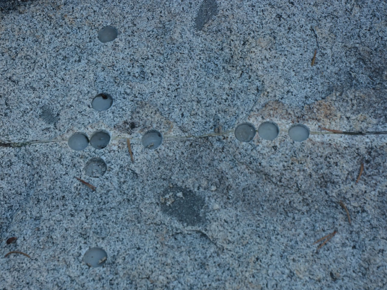
I am a bit startled to find a number of 1" diameter drill holes along a small mineralized joint or fault right next to camp. This was clearly the work of a geologist; it looked as though they might have tried to fill the holes with plaster of some sort, but most of that is now gone. It turns out there is a rich literature on the "Bear Creek faults"--for instance a 2008 Journal of Structural Geology paper that in turn cites several earlier papers (I think though this is the work where the cores were created; the authors contend that the small faults I can see have pseudotachylite in them indicating they slipped as earthquake faults). Kind of funny to stumble into this.
With light fading, I watch for a chance to get a good photo of Seven Gables. The llamas are brought back by camp. I finally set up my tent (Megan and Matt had theirs up quickly) and we all go to bed. Tomorrow should be a fairly short day, though we plan on crossing Selden Pass. A question will be weather; although we lucked out today, we might well get drenched tomorrow as it doesn't seem that anything has really changed.
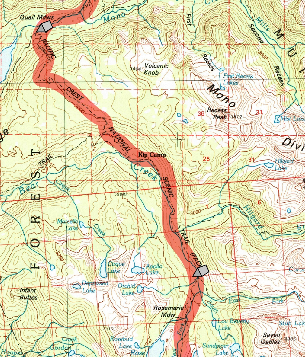
Day 8. 9.8 miles to Bear Creek crossing and camp; 7900 Quail Meadows, 9960 Bear Ridge summit, 8950 Bear Creek Jct, 9570 Bear Creek crossing
9.8 miles, 1670' net elevation gain, 2680' total elevation gain
Total to this point: 68.4 miles traveled, 13,400' total elevation gain.
prep | 0 | 1 | 2 | 3 | 4 | 5 | 6 | 7 | 8 | 9 |10 | 11 | 12 | 13 | 14 | 15 | 16 | 17 | 18 | 19 | 20 | 21 | 22 | coda | CHJ home