|
 Our fourth day will see us drop in elevation by day's end, but the middle of the day we'll be even lower. At least it is mainly a long descent followed by a steady uphill instead of the whipsaw we had yesterday.
When I head up the hill to use the facilities, I encounter a fellow marching up the trail from Shadow Lake with an American flag and a Marine flag dangling from his pack. This fellow's name is Nick and he is on a mission to raise awareness of suicide by veterans by carrying the 22 push-up challenge to the Muir Trail; this is also to encourage vets to get outdoors. We chat awhile; their plan (his buddy is coming up behind him) is to do the push-ups on the passes when they are crossing passes. It turns out he is from Colorado as well (the first of several Coloradans we run into this trip). They head on down the trail well before us, but we'll cross paths again.
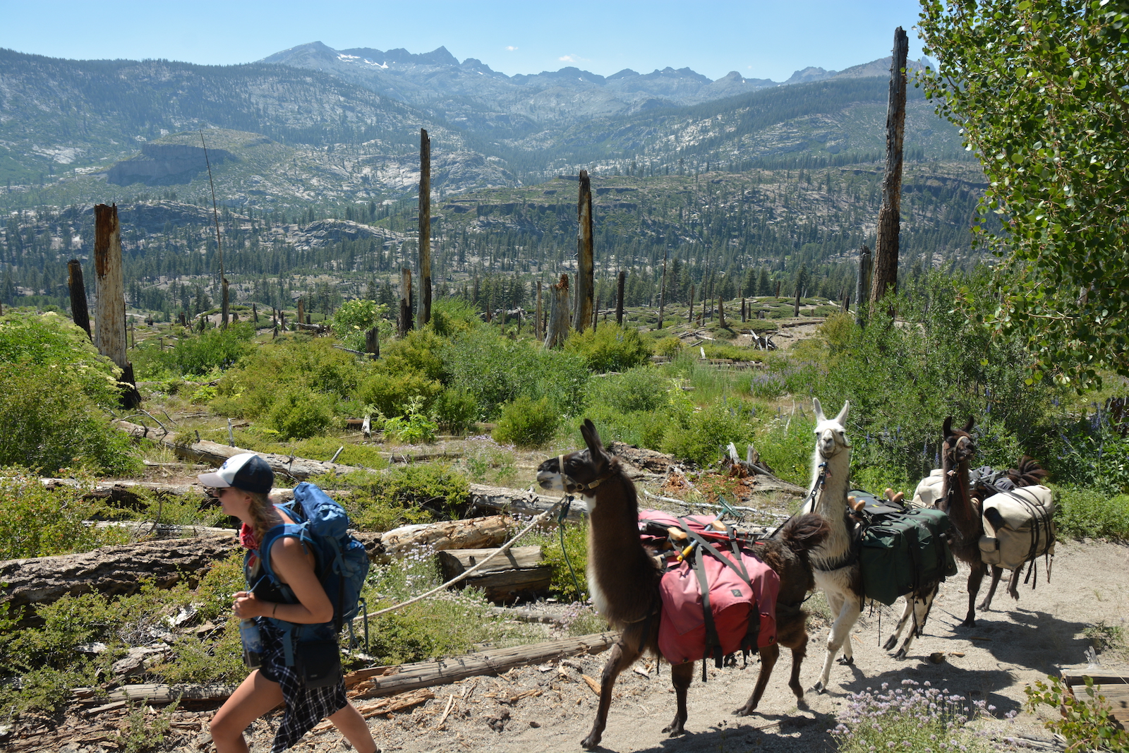
Figuring we aren't going to get an early start, I move the llamas up the hill to some grass while we eat breakfast and get packed up. The flies rise up in the calm warm air, slowing down all activities but swatting. Things are not as brisk as yesterday; we finally pull onto the trail about 10 am. The trail takes us across the small stream draining the lake and then up and over a low divide to Gladys Lake. Beyond that we encounter the results of a massive winter windstorm: enormous trees have been thrown down across the trail. No doubt the trail crew work the following spring was intense.
Megan suggests we greet other hikers with llama jokes. Of course we then have to come up with llama jokes. Megan's first attempt tries to use the llama/lama homonym: "What is the religious animal on the trails in the mountains?" "The Dalai pack llama". She launches a better one: "What does a llama see in his mirror in the morning? -- His spitting image." This one works pretty well on one group. I struggle to work with the sounds -- "Where do expectant llamas go? -- Llama Lamaze class" (or Llama mas class). This is only good for older hikers; Megan doesn't understand it at first and then decides it isn't funny. But with the right crowd at least it gets a smile. I try and rework the Dalai Lama angle and eventually settle on "What is a religious llama's favorite off-Broadway play? -- Hello Dalai llama." In all this I have to smile; part of the reason I am on this trail is silly stuff like this.
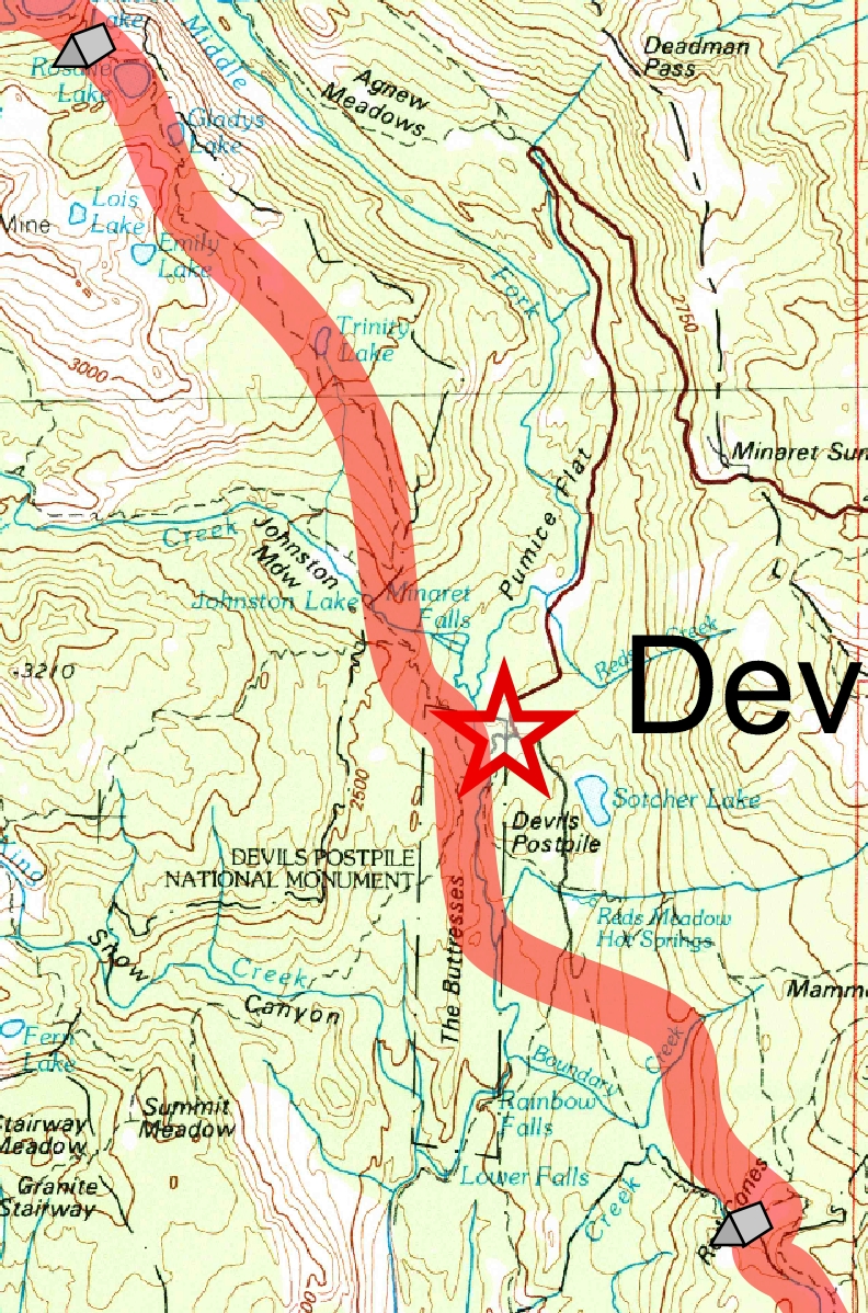
The rest of the descent is one of the dullest parts of the whole trail in our opinion. We are passing some of the Trinity Lakes, but they are mainly hiding in the woods to the side. Eventually as we descend we cross a low ridge and enter the Minarets Creek drainage. Peeking through the trees to our right are the spires of the Minarets. We never get a really good clean look before we hit bottom and pass Johnston Meadow and follow Minaret Creek down towards the San Joaquin. As we pass the top of Minaret Fall I realize that the top of my cheap fake bota bag is missing. Trying to keep water from sloshing out is a bit of pain and I start wondering if I might get a replacement at Reds Meadow, which we will pass later in the day.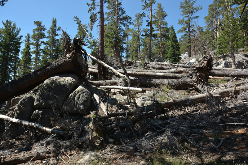
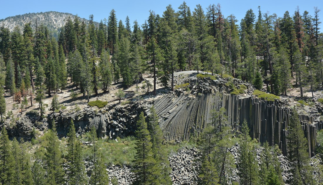
Hitting the bottom of the grade, we reach a big trail junction right near the edge of Devils Postpile National Monument. The Pacific Crest Trail, which had been across the San Joaquin canyon, comes back to meet the Muir Trail. Only the PCT is marked at the junction, seeming to confirm its primacy in the world of the Forest Service (in the parks, it is the Muir Trail that is labeled and the PCT left out). We pass straight through, leaving the Muir Trail to go close enough to the postpile so that Megan can go and have a look. She isn't that enthused, but it seems a shame to be so close and not visit. A short distance beyond the first junction we reach another where a bridge over the San Joaquin is marked "no stock." I sit in the shade with the llamas while Megan goes across to look at the Postpile. A few folks come by and look at the llamas and chat a little. Megan finally returns--turns out she accidentally took the trail to the top of the Postpile, thought the glacially polished hexagons at the top were kind of dull and then realized it was the other trail that led to the base. So tourism served, we head south on the trail on our side of the river. The climb over a ridge is a bit of a downer, but we get a nice view of the Postpile across the river. Soon we head back down to the river, cross on a bridge and then tie the llamas up so we can have lunch down by the river. As often happens, some hikers wandering by check out the llamas while we eat.
We are now at the very bottom of the day's hike--in fact, the very bottom of our entire Muir Trail hike--and face a thousand foot climb over about 3.5 miles. It isn't so much the elevation gain as when it comes--late in the day--and how exposed to the sun we are as we make the climb. We want to make good time--it is well after 1 pm already--but I'm thinking that a quick detour to Reds Meadow to grab a replacement for my bota bag would be a good idea. Megan points out that we are kind of short on water bottles; she would like one she can sip. She'd also like sugar for her tea, which we don't have. That seems reason enough to stop, so when we reach the first trail junction to Reds Meadow I head that way and instruct Megan to go to the next one, which the Wenk book shows as being at a stream a short distance ahead. Megan didn't want to come with the llamas, and it was probably just as well as the trail goes right by the pack station at Reds Meadow. Soon I am winding my way through backpackers happily unpacking their resupply buckets as I get into the store. They have a metal water bottle with Mt. Whitney on it that seems exactly what Megan wants, but no regular water bottles. Also nothing like a bota bag or a little cap or nozzle that might fit on mine. So I pick up two bottles of water, one large for Megan to use, a small one for me where the cap might just fit on my bota bag. There are no sugar packages, so that's a failure. I pick up some milk and an apple juice for Megan and a milk and a candy bar for me. Armed with my loot, I hustle outside to my pack and jam things in while scarfing down the candy bar. I head over to the water faucet and fill all the water bottles I have before heading into the restaurant to see if they have sugar packets. Turns out the answer is no, but they'd pour some in a bag for me. Silly me, I say no; it is only when I am heading back to meet Megan that it dawns on me that I have ziploc bags and could easily have gotten some sugar. Oh well. One more trip into the store to grab another milk and then I hustle down the east trail to the southbound John Muir Trail. Just before the junction stands Megan with the llamas; she is somewhat concerned. There is no stream despite the map in the Wenk book (one of the few times I regret trusting that guide; the stream is apparently quite ephemeral and easy to miss), so she plowed on past the junction quite some distance before deciding she must have overshot the mark. Some other hikers gave her advice and she doubled back, so tragedy was averted, but she is a bit annoyed. I give her the water bottle, which she admits is just what she hoped for, and the other goodies and, nearly 3 pm, we are off on our uphill climb.
What makes the climb so unpleasant is that the forest the trail used to cross was burned off some years back. Although this means there are wildflowers to be seen, and we have fine views back to the Minarets, the sun is beating down on us. It is hot. Nevertheless, Megan, with Sarek in the lead, keeps a steady pace as we climb up the trail. At least the trail's grade is equally steady and we are spared the kind of up-and-down we had earlier near the Postpile and in spades yesterday. The trail finally reaches the edge of the burn area and enters forest as the trail starts to contour up the east wall of the San Joaquin's valley. One large switchback carries us up near the elevation we need, and then we finally come in view of Crater Creek. We stay left to head up towards Crater Meadow, looking for a campsite near the meadow. Megan is unhappy we have turned off the Muir Trail, so we stop and start looking for a campsite. Megan looks across the small creek near us while I head to the upper end of the meadow. A large flat sandy area looks appealing to me--the grass nearby is perfect for the llamas, so it would be easy to monitor them from camp. Megan though thinks she has a decent spot in the woods, but it is bushwhacking to get to her spot and there is no sign it has ever been a campsite and, in addition, it is rather too close to the stream.
We are at loggerheads. Megan doesn't like the idea of being farther up this trail; she says we didn't look farther on the main trail and maybe there is a good site there. Thinking this highly unlikely but hoping to restore some peace, I say I will go look and she should watch the llamas. So I head back to the junction, cross the creek and start looking. A site right at the crossing is taken, which is a bit too bad as it looks like there might be adequate grass behind it. I head around and the trail turns to the left, following the base of the southern Red Cone. Just as the trail looks to start its climb away from the meadow, I see a flat area that has potential. Heading over, there is grass kind of off and on through the woods, probably enough for the llamas. The campsite isn't as nice as the last few we've had, but there are some large trees we can sit on and water isn't too far away, so I figure this will do. I go back and collect Megan and the llamas and soon enough we are at this camp. In crossing the creek, we advance from the Ansel Adams to the John Muir Wilderness, where we will stay until we hit Kings Canyon National Park.
Megan unloads the llamas as I try to figure out how to put them out to graze. It is time to make my replacement picket rope from the parachute cord I carry for hanging food. I tie some loops at intervals along the line and then string it out between the two meadow screws. Soon the llamas are munching on anything green they can eat. Megan has her tent up and wonders if the sound we hear is a waterfall. I walk a little ways farther east and see, past a number of fallen trees, that there is a fall from a stream coming from the south. Megan is soon wandering over there and washing in the waterfall; she comes back saying she has now been in a creek, a lake, and a waterfall and so has conquered three different types of water. I, in contrast, probably could cut through dust on parts of me to reveal the full history of our trip. I take a collapsible water basin we have and fill it. Using some camp soap and a camp towel, I basically do a sponge bath. My socks have been suffering, so I wash them in the basin as well. I'm certainly not as clean as Megan, but I am better than I was earlier.
As is our fate, there are flies and mosquitoes, so the usual activities are accompanied by the sounds of swatting and an occasional curse. The llamas have it worse as the flies really go after them, sometimes drawing blood. I move the llamas a few times as the grass is thin, at one point realizing I am nearly right behind somebody camping to our west. He comes over and asks a few questions and offers that it doesn't bother him if the llamas are there.
Dinner is soon a forgotten affair (I am still on my burrito,much to Megan's disgust). As we bed down for the night, safe from the bugs, I plan on rising early. South Red Cone is supposed to have a neat view, says the guidebook, offering directions on climbing it; sunrise from there might be worth the effort.
We don't really know it, but we have suffered one of the tougher days we will have on the trail. Given we are still getting used to hiking the trail (and I am now fighting a blister on my right foot that hadn't fully healed from pre-JMT hikes), given a 10 am start, and given the hottest temperatures of the trip, making camp before 5 is an accomplishment. Only when we start to hit serious passes in our last week will we be challenged again, and by then we will be pretty hardened.
Day 4. 6.4 to N Postpile Jct, 0.5 to postpile loop, 0.35 to South Postpile Jct, 1.7 to Reds Meadow Jct, 3.0 to campsite, Crater Meadow; 9350' at Rosalie Lake, 9610' at Rosalie/Gladys saddle, 9550' at Gladys Lake, 9710 at Gladys/Trinity saddle, 7550 at Postpile loop, 7740 high point, 7450 at Middle Fk San Joaquin, 8690' at Crater Meadow.
12.0 miles, 660' net elevation loss, 1850' total elevation gain
Total to this point: 32.2 miles traveled, 6420' total elevation gain.
prep | 0 | 1 | 2 | 3 | 4 | 5 | 6 | 7 | 8 | 9 |10 | 11 | 12 | 13 | 14 | 15 | 16 | 17 | 18 | 19 | 20 | 21 | 22 | coda | CHJ home