|
 Last night I got word from Greg that we can exit the 13th and he will meet us. The bad news from our perspective is that we won't get back to Sonora until the 14th anyways. That sort of means that we will burn our extra day hanging out at Horseshoe Meadow. Well, we will just get there early and hope that Greg somehow arrives earlier and we can head out despite what he thinks.
What all this means is that we now know what we are doing, which is a bit of a relief. Today should be an easy day; Crabtree Meadow is a bit over 8 miles away without a major pass, easy after averaging 12 miles and over 2500' of uphill the previous 3 days. The sun rises early here near Tyndall Creek, courtesy of the gap in the Sierra at Shepherds Pass, but it was a cold night so we aren't exactly zipping around in the morning. The grass here isn't all that good, but tonight things should be better at Crabtree. Breakfast includes eggs this morning, which is nice, but that also slows us down a little.
While I am doing chores, a fellow walks up and wants to talk llamas. In a way this is a surprise; although we have talked with lots of hikers on the trail, the only time we were approached in camp was back near Quail Meadow by the woman who was hoping to give the llamas lettuce. I think this fellow hopes we own the llamas; it sounds like he has some experience with the animals and is hoping to learn about buying them. I really don't have much useful information for him, so he heads back to his camp nearby.
We leave camp about 9:40 with more confidence than in the last couple of days. We know we will be in Crabtree a couple of nights, then somewhere like Rock Creek and then out. The transition from facing four passes in four days to realizing the trip is nearly done feels abrupt. At least there is still the summiting of Whitney to cap the trip.
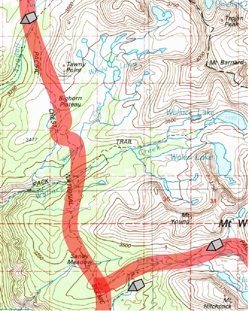
After we double back a short distance to the crossing of Tyndall Creek, we turn back along the Muir Trail, passing through a couple of campsites on the other side of the creek. The trail now starts rising to cross the Bighorn Plateau. It doesn't take us long to get by the frog ponds, which look like a real mosquito heaven. From here we rise up a bit more steeply to the edge of the Bighorn Plateau. We get out of the trees pretty quickly and gain great views of the Great Western Divide over the upper Kern Canyon. I look back to Caltech Peak and just see Forester Pass over the edge of Diamond Mesa before we crest the edge of the Bighorn Plateau and the view behind us disappears.
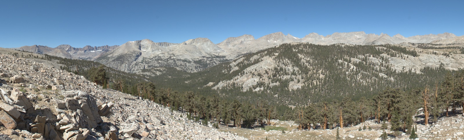
I have long looked forward to revisiting the Bighorn Plateau. Long ago I had camped near Wright Lakes, to the east, and hiked onto the Plateau near sunset. The Upper Kern is surrounded by high peaks on all sides, but they are at a distance, which creates an atmosphere of uncommon depth to the mountain landscape. As we crest the edge of the plateau, we gain a new vista of Mt. Whitney and the almost bizarre small cirque cut into the west flank of Mt. Young, a feature that resembles nothing so much as a toilet seat. Farther south we spy Mt. Guyot, which marks the edge of the end of our adventure.
Hiking the upper Kern is really unlike any other part of the Muir Trail. Vistas are consistently long, and the high forest of foxtail pines is very different from the whitebark pines and lodgepole we had near timberline to the north. Peaks are less thoroughly excavated, so many ridgelines still carry gentler slopes instead of the sharper glacial ridges we were accustomed to farther north. This is also one of the tougher areas of the Sierra to get to; were it not for the lure of Mt. Whitney and the Muir Trail, it would probably be far less traveled (Indeed, much of the rest of the high country around the Upper Kern is far emptier).
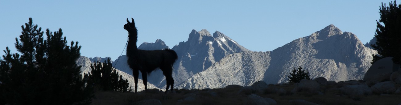
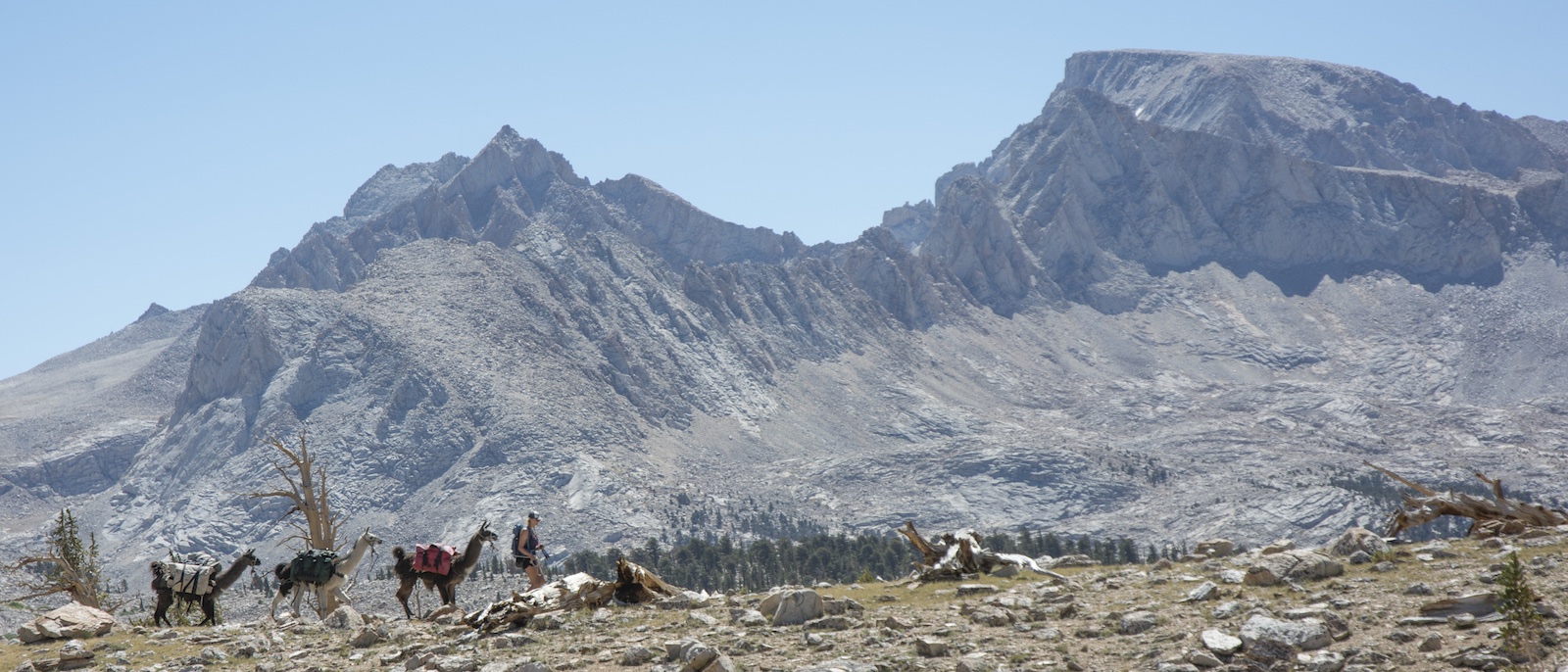
Our time on the Bighorn Plateau is too short. Had grazing been allowed in the area (it wasn't entirely clear from the grazing regulations), I might have lobbied to burn our extra day here and do some short trips. (We could have turned up towards Wright Lakes and camped up there. Oh well.) As we approach the edge of the plateau, a lateral moraine from the Wright Creek glacier is apparent a little ways to our left, underneath Mt. Whitney. Both Megan and I sense a possible llama photo, and so she heads over with the llamas to pose on the ridge under Whitney. The end of the Muir Trail is literally in sight.
The trail now winds back down into the forest to cross Wright Creek and then continues on down a long switchback to reach Wallace Creek. As we make the turn on the switchback, we see a mule wandering up towards us. The mule is taken aback by the llamas and so stops. Megan takes our spare lead rope and heads down to capture the errant beast, finding the name Harold on the bridle. We decide to have her go in front with the mule, which turns out to be a mistake. The mule is constantly looking back to see where the llamas are. Megan quickly meets a large group of hikers; they convince her that the mule needs to head back north, and so she releases the mule. I catch up as the mule goes past us well up the hillside. The large group is actually a stock party: the packer and the animals will be behind, they say, about two hours, so we should meet them in one. They know though that the mule isn't theirs.
A bit farther down we meet a woman who had been eating lunch nearby. It takes awhile for me to understand her story as I manage to mentally confuse south and north and have trouble believing there is a stock party actually heading south ahead of us. She tells of a man on a white horse who came down the Muir Trail heading south with four mules. The lost mule showed up 20 minutes later; she figured the mule belonged to the man on the white horse. This seems strange; after all, if the mule had been with the man, it should have had more than a bridle.
A little bit farther we find a large collection of hikers gathered about Wallace Creek. Here the High Sierra Trail joins the Muir and Pacific Crest Trails for the journey on to Crabtree Meadow. The humanity here seems to be made up of a bunch of different groups, which is unusual. We recognize that stopping here is likely to mean a half hour or more of llama talk and photos, and we would rather push on, so we answer some questions as we continue moving. But our short conversations produce a startling revelation: there is a forest fire at Horseshoe Meadows. Our exit point has been closed.
We climb up the trail a little ways hoping for a view. When we pull off, we inadvertently turn onto an abandoned part of the Muir Trail. We are in view of the trail, hoping that the stock party will pass us while we eat our lunch and mull over our situation. My view is that we know nearly nothing as of now: the fire could have been short-lived, or word of the closure is exaggerated. We will meet the ranger at Crabtree but figure we will ask our contacts in the outside world to check for us: I send both Greg and Anne emails through our YB device, which now proves to be a very wise investment indeed. With lunch eaten and messages sent, we resume our trek on the trail.
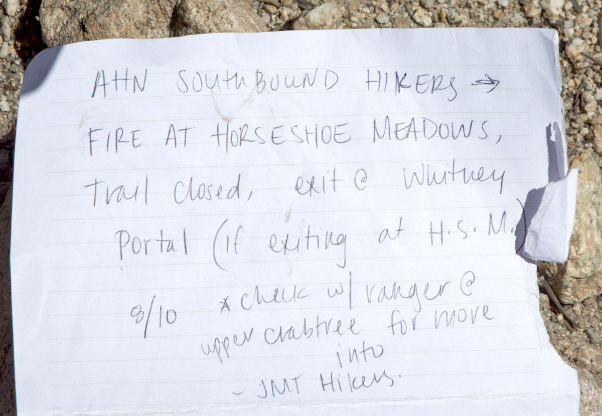 We now rise up to the divide bounding Wallace Creek. We now descend and pass the upper end of Sandy Meadow. A little ways farther brings us to the junction of the Pacific Crest Trail with the Muir/High Sierra trails. We will follow the Muir and High Sierra Trails to Crabtree, but there is a note at the junction. This confirms that the fire is serious enough that the park is diverting hikers over Trail Crest to Whitney Portal. We, however, cannot go that way.
The trail turns and simply plows right up and over the lateral moraine on the side of the Whitney Creek drainage, an annoyingly steep and sandy little section of the trail, before making a nearly bizarre set of turns to finally drop to Whitney Creek. A sign directs us to cross the creek to get to the ranger station. In crossing we pass a major camping area where clothes are out drying and gear is spread out. We cross the creek (with admirers, as usual) and turn left to reach the ranger station, which sits at the end of a short trail stub. We are not the only customers. A couple of apparently east Asian hikers are discussing their options for escaping from Whitney Portal; they are very concerned that they will get to Whitney Portal after the store closes. The ranger reassures them that there is a backpacker campground at the trailhead, so they won't be in much trouble if they arrive and cannot get a shuttle ride down to Lone Pine; at worst, they will be able to arrange a shuttle the next day. Given the number of hikers being diverted, I imagine they will have plenty of company. The ranger then sits back with his skillet of pasta--evidently a late lunch--and finishes a conversation with a fellow sharing his porch who is looking to climb Mt. Williamson. We wait for all this to end before introducing ourselves.
The ranger introduces himself as Rob (I first heard "Bob"). It is his day off but with the fire, he recognizes the need to be available. Yes, he says, he has been told to direct hikers to exit over Trail Crest, but this is not an option for us: the trail down is too risky for stock (in fact, it was built as a stock trail, but presumably the shear number of hikers on the trail makes the presence of stock a hazard). He manages an occasional bite from his skillet as a report comes in on his radio updating the fire. It is 110 acres and 10% contained, it is well away from the structures and vehicles at Horseshoe Meadow, but the trailhead is closed indefinitely. Hikers are advised to find alternate exits.
So we ponder this. I figure that means we have to return to Vidette Meadow and head out to Onion Valley; this means traversing Forester again. The ranger suggests Shepherd Pass, which surprises me as I had heard it is closed to stock while the trail is being repaired. As the temporary Tyndall (permanent LeConte) ranger had just hiked up that, Rob gets him on the radio (after a long pause for other radio traffic) to ask about the suitability of the trail for stock. His answer is pretty basic: he doesn't think so. The ranger offers that he has some emergency food; I say that we had planned to be out the 14th, which gives us enough food to have Megan climb Whitney and us then exit at Onion Valley. He also offers use of his satellite phone, an offer I appreciate in case we need faster two-way conversations with Greg. We decide that we will stay in the area for a day and let Megan climb Whitney while things develop. Rob offers that we could camp at Guitar Lake--in fact, given we have just llamas, he thinks it would be fine if we spent two nights there. The grazing regulations seem to preclude that, and I mention that the rules are confusing but seem to be rewritten to not allow any grazing. His response is that use by private parties with llamas and mules has always been allowed and is OK by him.
While we talk, Rob asks if the llamas are from Potato Ranch. I am startled but confirm this. He says he had seen problems with llamas from there before, with one dying because the hiker with it tied it up poorly and left it, and another that simply sat in the trail and wouldn't go. He then comments that our llamas seem to be in good shape; how have they done? Just fine, I answer; we have come from just south of Yosemite. This surprises him a bit; he had thought we had come in from Onion Valley. He now offers that he'll have to rethink his opinion of Potato Ranch [Later, on the drive back to Sonora, I ask Greg about this and he says that those were not his llamas. Llamas that simply stop in the trail like that are usually privately owned and not trained for hiking. So how his operation got tangled with the ranger's bad llama experiences remains a mystery.]
With the offer of camping at Guitar, our easy-ish day suddenly becomes a much longer day. It is another 3 miles and almost 1000' up to Guitar, so we thank Rob and apologize for interrupting his day off. We head back through the hiker camp, cross the creek again and turn right, towards Whitney. We will now take the llamas to the very edge of where they are allowed.
The trail rises up the valley of Whitney Creek (again, initially, in a rather odd choice of grade), swinging away above a meadow only to circle back as it rises over the lip of the basin holding Timberline Lake. Megan asks if this is Guitar and I say no, and ad that camping is not allowed at Timberline. Whitney is now in full view over the lake as a massive trapezoid fluted with avalanche chutes. As we continue, some hikers come down. When we say we are looking to camp at Guitar, they say there are a lot of people camped there, but when I press and ask if it is totally full up (after all, they are coming down), they say that it is a big enough area that we should be able to find something. Farther along the trail we pass a packer descending from Guitar with unloaded mules. I ask if he knows anything about the lost mule; he thinks a moment and says he thinks he knows whose it is, probably another fellow from his outfit. So we continue up some switchbacks and finally reach a crest with a view down to Guitar Lake. Megan immediately spies a broad open sandy spot to our left that, miraculously, nobody has chosen to use as a camp. So we quickly move over to this spot and unload the llamas.
Although there is some grass nearby close to Arctic Creek, between the campers and the too-great number of things growing there, I decide to take the llamas down to the main meadow on the north side of the lake. The meadow itself is a good match for our needs and soon the llamas are picturesque features of the landscape, munching the grass. Although nobody is camped in the meadow, it is a circus around it. Tents are wedged into increasingly unlikely nooks and crannies, some little more than colorful tarps. Presumably things are tighter than usual here with the diversion of hikers over Trail Crest (perhaps a welcome development for those whose Forest Service permits would not have allowed them to exit that way). Fortunately there is little chance of rain, unlike my experiences here more than 30 years earlier when tremendous thunderstorms rolled through.
I check messages on the YB and Anne has forwarded information from Inyo National Forest that matches what we heard on the park radio. Nothing much more to do now, so we prepare dinner and get Megan's snacks ready for the big day tomorrow. She has saved one of the Snickers bars she got from Nick (the marine from Aurora) for this climb, and I've told her to take whatever she wants; it is a decently hard hike. However, she won't get two packets of oatmeal in the morning since we now might need one for that last day that we thought we didn't need. I eat a whole package of freeze-dried spaghetti and peas and carrots; Megan shares the veggies along with her freeze-dried meal. She retires early since she would be on the trail early tomorrow.
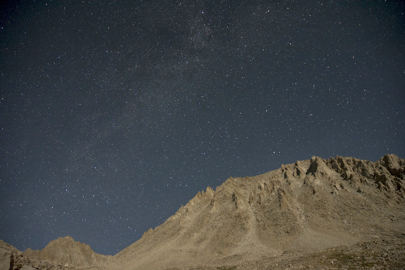
I get to prepare for the night by taking down the water filter, which was propped up using the tripod. I intend to take some night pictures, and I am hoping the Perseids are going to show up this time. Meantime a large orange cloud--smoke once again from the large fires near the coast--passes in front of the sun, making for odd colored stripes draped across the massive front of Whitney. With the sun setting, I sit out for awhile. It doesn't seem nearly as cold as some other camps, and I enjoy watching the stars come out. I also check messages on the YB. Anne has an update on the fire: 400 acres now, 25% contained with 268 firefighters and lots of equipment. Greg meantime has weighed in on the ranger's idea of trying Shepherd Pass: it is a firm no from him; that trail isn't safe for stock, period. He will negotiate with the Forest Service in the morning to see what can be done. I am sleeping in the tent, which I set up figuring I'd want to leave it up awhile given that I would be in camp until at least noon. We plan on getting Megan off in the morning about 7:30 or so, which should allow ample time for her with only a daypack to summit and return.
When I go to bed, I reflect on the strange turns the day has seen. When we set out in the morning, our plans were firm and we were looking forward to being able to dip into our food stocks a bit more deeply; I was looking forward to a couple nights in the same place, where I might relax and maybe set up the shower again. Now--who knows? At least we have the supplies to do whatever is needed without sacrificing the climb of Whitney, which has excited Megan for some time now.
I try a few photos from my tent with the stars out. Moonlight illuminates Whitney, but the time exposure brings out the Milky Way nonetheless. No meteors that I notice, though. I'll try and wake up early to see about meteor pictures...
Day 19. 11.4 mi to Guitar Lake (+0.4 to Crabtree RS); 10,920' Tyndall Creek camp, 11,430' high point Bighorn Plateau, 10,380' Wallace Creek, 10,960' Wallace-Whitney saddle, 10,635' low point, 10,990' high point, 10,630' Whitney Creek, 11,580' Guitar Lake camp.
11.8 miles, 660' net elevation gain, 2400' total elevation gain
Total to this point: 178.4 miles traveled, 35,140' total elevation gain.
prep | 0 | 1 | 2 | 3 | 4 | 5 | 6 | 7 | 8 | 9 |10 | 11 | 12 | 13 | 14 | 15 | 16 | 17 | 18 | 19 | 20 | 21 | 22 | coda | CHJ home