|
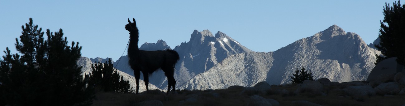
Sunrise reached the top of the Ritter Range about 5:40 am when we were at Thousand Island Lake, so I know I need to rise early if I am to catch it from South Red Cone. Rather than insult my feet any more than necessary with boots, I stick with wool socks and my sandals. The book suggests heading up the Muir Trail a ways and then cutting over to the cinder cone, a very young addition to the landscape here. I am up before sunrise and chugging up the hill thinking I am in good shape, but I turn towards Red Cone a bit too soon. When I hit the base of the cone, there is something of a trail, but as it tradition on these sorts of things, I frequently find myself sliding backwards as I move forwards. Eventually I meet up with a far more serious trail and my way up gets a bit easier. Still, I am sweaty when I finally top out and get my view.
There is some real satisfaction in looking north and seeing Ritter and Banner now distant instead of looming over us. A sense of travel, that we are actually getting somewhere, emerges from this view, and it is something of a relief. To the right is Mammoth Mountain; had we been inclined, we could have used our cell phones the past couple of days because the cell towers constructed for the winter skiers reach over to this side of the divide. The canyon of the Middle Fork of the San Joaquin is in shadow, the Ritter Range beyond is in a rather hazy orange glow that steadily brightens as I watch. I wander around to the south side of the crater hoping for a view to the south, but there really isn't one. I return to the north edge and then turn down the better-trodden trail, descending it to near the northeast base of the cone before struggling across all the downed trees to reach the Muir Trail. (Downed trees from that winter windstorm are a feature practically the rest of the way in the Middle Fork drainage).
 Of course the sun is going to be slow to come to Crater Meadow, so I decide to move the llamas and let them eat a bit more. I look around a bit harder than the night before and startle a deer across the creek--the deer was in the edge of the main meadow. If I can just get the llamas over the creek, they will have a feast. A search finally turns up a place where I think I can coax the llamas across, so I go and get Sarek. He really doesn't want to cross, but eventually I persuade him to come over. Soon he is happily consuming grass while tied to one of the meadow screws. I now go back for Theo. Theo turns out to be more eager, probably because he can see Sarek and partially because of his nature. When we come to the stream, I hop across and start to turn, figuring I will have the same battle with Theo I had had with Sarek. Instead I have a llama landing right on top of me. I had forgotten one of Greg's lessons--going over certain narrow things like this narrow little creek, when you hop across you keep on going because the llama will be right on your heels. Well, laying on the ground with a llama over me, I recalled that lesson rather more vividly than should have been necessary. No damage is done, though, and before much longer the three llamas are getting the meal they should have gotten the night before.
Part of the logic of spending time climbing the cone is that I thought today would be an easy day, so letting Megan sleep in while I do chores and climb the cone seemed wise, but when I consult the guidebook I find that Duck Creek, my planned goal, is not the 5 miles I thought but is 8 miles away. Rats. That and the 1500' elevation gain are demoralizing. There isn't much to do but pack up and hit the trail.
Some hikers pass by as we are getting breakfast, and it just underscores a theme of the trip: many backpackers are early risers and on the trail well before us. By the time we are really packing, the flies have become nearly insufferable. There is no breeze. It is a relief to start walking if for no other reason than at least some of the bugs won't keep up. That said, the flies are everywhere and our entertainment for the climb is seeing how many we can kill. The horseflies are the worst, but thankfully they are few in number. The more regular flies, while an incredible nuisance, are slow to bite and pretty easily picked off.
As the trail rises, I am noticing discomfort in my left heel. Having made it this far without that wound reopening, I am thinking it is just the scab being a little irritated, but later on I find that in fact a large blister has opened on my Achilles tendon. Grr. The cause, no doubt, is that because I washed the heavy socks last night, I shifted from my very heaviest socks to the second pair, which is thinner. There is nothing to do but patch this up as best as possible; after some failed attempts in the days ahead, it will be a series of bandaids across the wound that holds true and prevents things from getting worse.
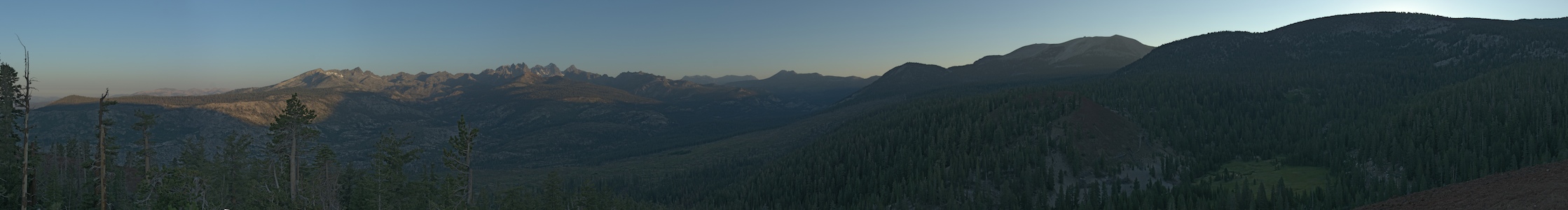
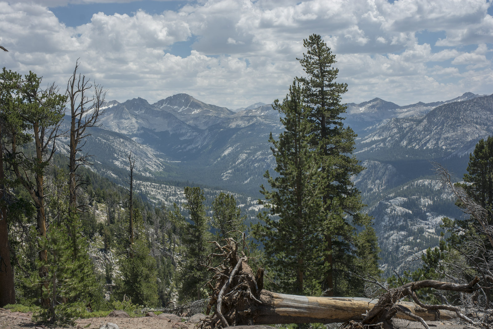
Our trail is mainly in the woods, but we emerge near meadows along parts of Deer Creek to get a little more sunlight. The maps and guidebook warn us of a five mile stretch ahead with no water, but we have used little this morning and now have more water bottle storage than before, so we push on past the last water as we cross Deer Creek. The trail wanders upward; as it starts to bend to the left I ask that we pull off so I can take a little break--this seems like a spot with a breeze and a new view. Indeed, as we stroll a ways down from the trail, we are greeted with a view of the lower part of Cascade Valley, a large glacial gorge that we will travel near today and tomorrow. The breeze is real and relief from the bugs is welcome. We eat some of our trail snacks while marveling at the view. At the leftmost edge, we can see some of the peaks of the Silver Divide near Silver Pass; the divide continues to our right, including Silver Peak and Sharktooth Peak. Farther right we look down to where the valley merges with the San Joaquin. Far in the distance are peaks of the Merced Group, on the southern side of Yosemite National Park. It is something of a relief to come back out to views like this, and this in a section of trail the book describes as the most boring part of the Muir Trail. Megan and I agree that it was the stuff we descended yesterday that deserves that sobriquet.
Rejuvenated, we return to the trail and continue up, but now with an occasional view increasingly revealing the mountains ahead and the upper part of Cascade Valley. We've met a number of hikers going the other way and heard stories of flies and mosquitoes, but we heard that Purple Lake might not be so bad. This is adding another 2.5 miles and another climb to our day, but the thought of fewer bugs is really encouraging. When we reach Duck Creek we drop down to a nice campsite near the creek. I gratefully remove my boots for the time we eat lunch. We discuss whether to camp here or push on. Right now the bugs don't seem bad, but Megan likes the idea of a lake and the recommendations on Purple are pretty good, so we decide to push on after purifying some water (mainly for me).
We immediately begin to rise again, but soon things level out and then the trail swings to the left. At a trail junction we turn left to head up along the lake as camping near the outlet is forbidden. The trail swings across the top of a meadow; on the other side is a nice rocky promontory with what looks like a flat top. Megan offers to go check it out. After awhile she indicates that there is a good site there, though there are some people camped a little ways above that site. It looks pretty nice; it is in position to catch the breeze and so help keep the bugs down, and we can watch the llamas from there. Megan wonders where I would graze the llamas, but I indicate the big meadow. Though there is a stretch I'd avoid, the far edge looks pretty favorable. It's about 4 pm, not bad overall given everything, and soon the llamas are grazing, Megan is swinging in her hammock and life is reasonably comfortable. Soon Megan heads down to the lake to swim a little; I am down there soon as well getting water for camp, preferring the lake water to the stream nearby. Several folks come by to admire the llamas. We watch the llama admirers from a distance; some are very cautious about them, others, more curious, approach more closely. This is one of the busier places we have camped at (and will camp at, for that matter) and so the llamas get a lot of attention.
One thing I had noticed during the day was the development of clouds in the afternoon. The day before there were a few visible, but today the cloud cover was growing. It seems likely that there will be rain in the coming days, so some of our carefree behaviors will need adjustment. We have garbage bags in the panniers to help keep things dry in addition to the rain covers; so far, we've just left those jammed at the bottom of the bags. We'll probably have to change that in the morning.
As Megan retires for the evening, I wander about and chat a bit with some folks camped above us, closer to the side trail. I notice that they have big metal bear boxes and a big tent and chairs and surmised they must have been on a horse trip. Indeed, they have been there a few days and will stay a bit longer. The father had been a backcountry ranger in Sequoia for years and so we swap some stories about that area. He says he had come to know that area so well there wasn't more to learn, so he is now vacationing up in this neck of the woods. I ask him what he thinks of all the flies, and he says it is something he can't recall having seen. That is reassuring to me, for when Greg said it was like a five-year hatch, I'd have thought I would have encountered such flies before. Anyways, this fellow's daughter wants to know if she can meet the llamas, so I invite her to help me move the llamas in close to my camp for the night. So we trudge over, me sharing what little llama lore I have acquired. I had trouble getting the llamas over the creek earlier, so we end up going upstream to the trail crossing and back down on the other side. She holds on to the llamas while I set out our picket line against the base of our ridge. I clip the llamas in, thank the young woman, and we go our separate ways. In retrospect, this isn't the best place to leave them as they aren't all that far from the creek; I probably should have brought them to a spot beyond our camp. Oh well, hopefully nothing ill comes of that decision.
As I am fussing with my things at my tent, Megan lets out a hoot: "Did you see THAT?" she asks. No, I say, I didn't see anything. "It was a really bright fireball and it woke me up, it was so bright. It moved west to east." I feel bad that I missed it; I had seen a nice fireball our second night at Thousand Island Lake, but this sounds far more spectacular. After we stop talking there is a big boom. Wow. (We later learn this was a fireball seen over three states; it was a Chinese rocket reentering the earth's atmosphere).
Since we have now outstripped our original planned goal, I figure tomorrow will be more of a rest day. And a good thing, too; a short jaunt would be nice, especially if we are going to see rain in the afternoon.
Day 5. 8.0 miles, Duck Creek, 2.5 miles to Purple Lake; 8690' at Crater Meadow, 9200' at Crater/Deer Crk saddle, 9100 at Deer Creek, 10170 high point, 10010 Duck Creek, 10430 high point, 9970' at Purple Lake camp.
10.5 miles, 1280' net elevation gain, 2000' total elevation gain
Total to this point: 42.7 miles traveled, 8420' total elevation gain.
prep | 0 | 1 | 2 | 3 | 4 | 5 | 6 | 7 | 8 | 9 |10 | 11 | 12 | 13 | 14 | 15 | 16 | 17 | 18 | 19 | 20 | 21 | 22 | coda | CHJ home