|
(As on day 6, I've replaced the lake name with its new name of Nüümü Hu Hupi)
Day 7. One full week. Megan is annoyed that I keep track like this, but this is something of a milestone. What is more, we will finally pass out of view of the Ritter Range today. And last but not least, we will meet Matt today, which will bring a little fresh air into our group.
 Although I never quite got my nice rest day, the good news here is that we don't have far to go to clear the pass. Although some clouds are building as we pack up and start to head back to the trail, it isn't quite the concern as yesterday. Of course, we do have all our stuff in the garbage bags, and the rain covers for the packs are on top and sticking out for easy access. We carry our own raingear in our packs. Occasionally we look across the lake to monitor the progress of the other groups. By the time we depart, near 10:30 today, everybody else has pretty much cleared out.
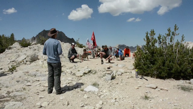
Switchbacking up, I am pleased to see we made the right call not to continue to a higher campsite last night. Sites are more exposed and not as pleasant as the one we used. As we pass the lateral to Goodale Pass, I pause, wondering if Matt is coming up this way. What is coming this way are some horses, so we move off the trail and ask if we are far enough off. The rider, a classic older mule skinner, seems to barely notice us in allowing we should be fine. He grumbles as he passes by. We're kind of amused at his behavior, but there was no drama, so we push on. The trail veers back left and actually is heading to near the lake that was above our site on Nüümü Hu Hupi. We swing pass a view down on Warrior Lake and turn south, a last few switchbacks separating us from the summit. Ahead we spy Nick, the marine with the flags, as he marches to the top of the pass. We are soon there with him, watching as he enlists a Boy Scout troop in doing his 22 push-ups at the pass. When he is done, he is thanked for his service by several of the adults in the area. After they have wandered off, we chat a bit more. He and his friend had stopped over at Reds Meadow, which is how they got behind us. He said they planned to do the push-ups on passes when practical. We compare notes on the fireball Megan saw: they were camped near Duck Lake and saw and heard it as well. That they heard it confirmed our observation (Anne had emailed that there were no reports of people hearing it). While he packs up to leave, we take some pictures and eat a snack.
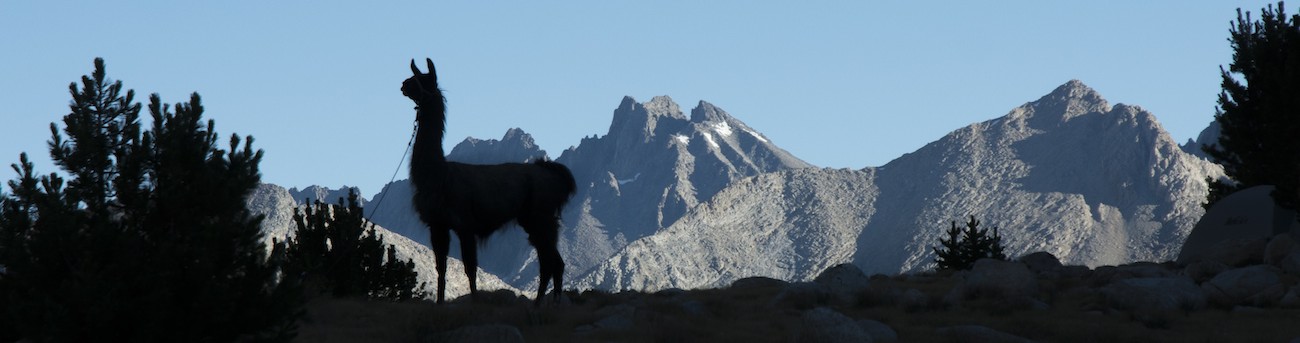
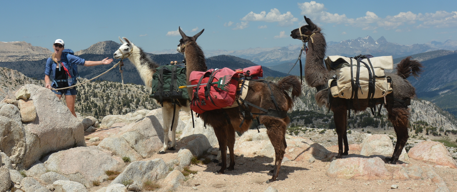
Silver is the first pass that feels like a pass. Our first pass, Island Pass, was a broad gap with lakes; there wasn't a single spot where you know you are on top. Here there is no question: views to both north and south let you know you are on the divide, and while there is a comfortable width to the pass for sitting and maneuvering, it isn't so broad and open that you have to wander about to figure out you are there. We return to the now empty push-up venue and arrange for Megan to parade the llamas before the view to the north. With Ritter and the Minarets in view for a last time, Theo gets a rare appearance at the front of the llama line.
Although Megan urges me to be quick, we enjoy our time at the pass. Now we head down, our view including peaks we will pass under in the next few days on our way to Selden Pass. We soon are passing Silver Pass Lake and then turning downward more steeply. As the forest starts to thicken, the clouds begin to rain, and the pack covers and raingear are donned. Although it looks to be pouring ahead of us, it isn't quite as bad where we are for awhile. Finally, though, we enter heavier rain. And then we encounter our first ranger.
The ranger is over near the creek doing something but hustles over to intercept us. I had never seen a Forest Service ranger in the backcountry, so this is a surprise. He asks if he can see our wilderness permit, and I allow he can, but I am not happy pulling it out in this downpour. He examines it and pronounces himself satisfied, but then asks if we are using any guides. I'm not sure what he means--is he asking if there is somebody along telling us where to go?--but then he clarifies that there are books and maps--indeed, the very ones we are carrying, it turns out--that have lots of bad information, that point people to illegal campsites while the publishers in New York are making lots of money, and the Forest Service is contacting these guys to get them to fix their books. [Our book was published by Wilderness Press, a niche publisher with small offices in Berkeley, and the book goes to rather great pains to point out what is and is not legal; the map in question uses the campsite list in the book. Although the book has some drawbacks, it is a big help]. Anyways, his point is that camps within 100' of water are illegal. His other nugget from the rulebook is that Sierra National Forest requires us to carry out our used toilet paper. This is news indeed, and so I ask what procedure he suggests for such an activity. He just says to keep a ziploc in a pouch and put the TP in there. Well, we'll see. As long as I have him, I ask what the outer bounds of stuff that must be in bear boxes is (he had mentioned used TP could stay out). Well, he allows that bug stuff could stay out and maybe fragrance-free toiletries. I ask about fires, as I still had the NO FIRES writing on the Wilderness permit. Fires are allowed below 10,000' in the backcountry, just as I was told when I visited the Sierra offices just over a week ago. Well that is good news. 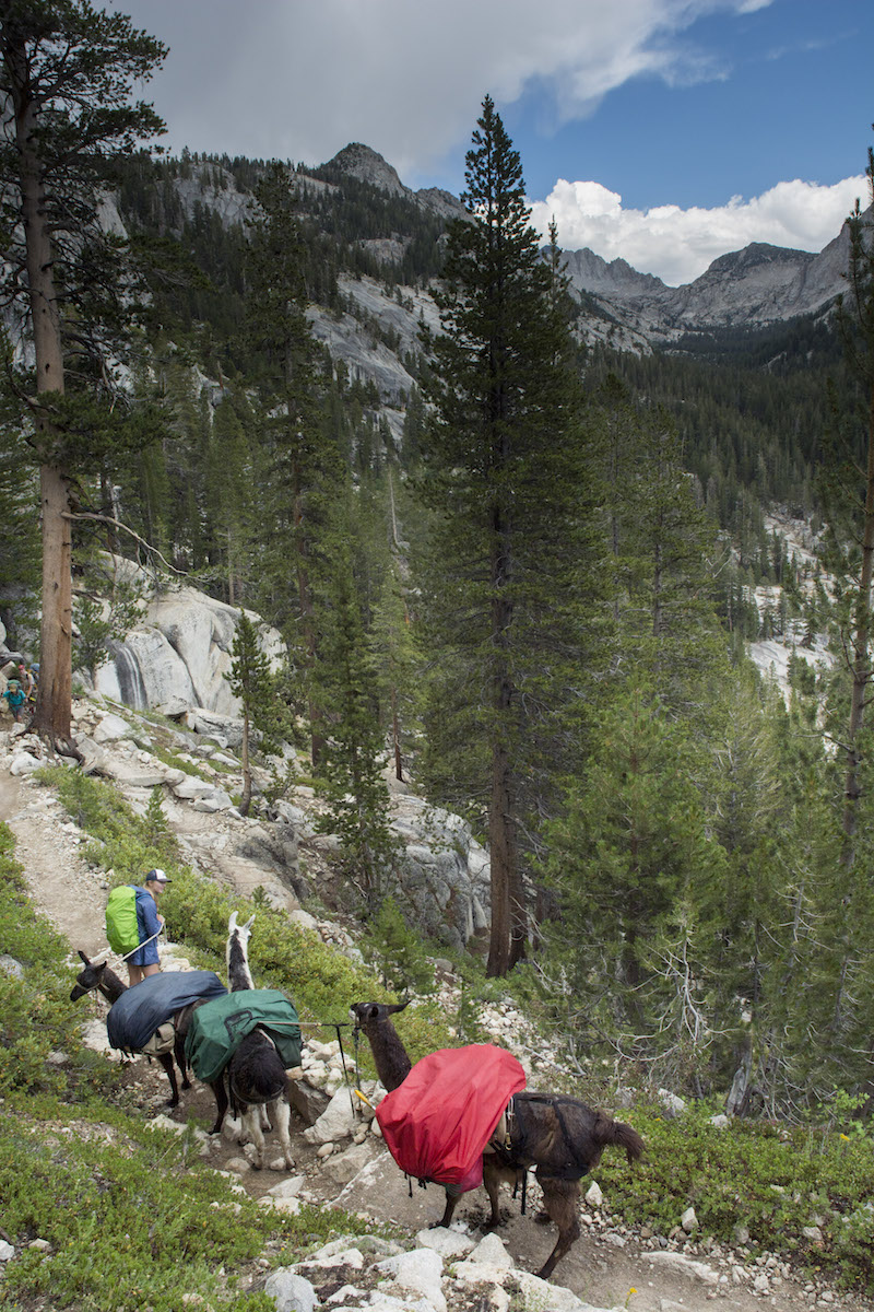
This ranger's earnest insistence on things spoke of a recent convert to forest rules. He was kind of missing one key piece: camps 50-100' are allowed if terrain doesn't permit you to go farther, and in a lot of this area, the terrain doesn't permit. The parks have a smarter view: established camps 25-100' from water are OK, but you have to be more than 100' away otherwise. The park rangers destroy camps they feel damage the resource near creeks and lakes but will leave or even improve sites that do not; the logic is that making new sites is worse than using ones already compromised.
As we prepare to depart, a fellow standing urgently nearby breaks in; he wants to know if we or the ranger have seen his hiking buddy. Neither of us have. He grouses that he is carrying most of his buddy's gear and now he can't find him. The ranger asks if they had a rendezvous, and he says yes, back at the Silver Pass Lake. Hmm, seems like that might be a good place to look, but moments later he is striding down the trail urgently. Well, who knows if his buddy was up at the lake still; presumably they eventually will figure it out.
Our descent gets pretty steep as we descend towards the North Fork of Mono Creek. A stream crossing here is sometimes tough, but Megan and llamas hustle across without hesitation. We have a bit of a view up to the eastern part of the Silver Divide, up where it would have seemed we would cross as we approached Tully Hole. But our course will now take us away from the crest and, for us, down low.
Soon the trees and canyon walls close in and we hit bottom, the creek roaring along as we turn right to head down towards Quail Meadow. Not too far down the trail is a familiar figure: Matt is waiting at the side of the trail for us. After some greetings, we turn and continue our descent.
We learn Matt's pack, with food, is at the bridge over Mono Creek a few miles down. He had ended up on the ferry and so didn't have to carry his gear far. He had looked around a little when he got to the bridge and thinks he knows where a decent camp might be found. Although we get an occasional raindrop, we soon are walking under a blue sky, the clouds choosing to hover near the higher terrain to our east. Matt jokes that he has a poncho, but the package says "fits most." He kind of suspects he isn't one of the "most" that this poncho will cover. Given the past couple of days we've had, he may well get to find out.
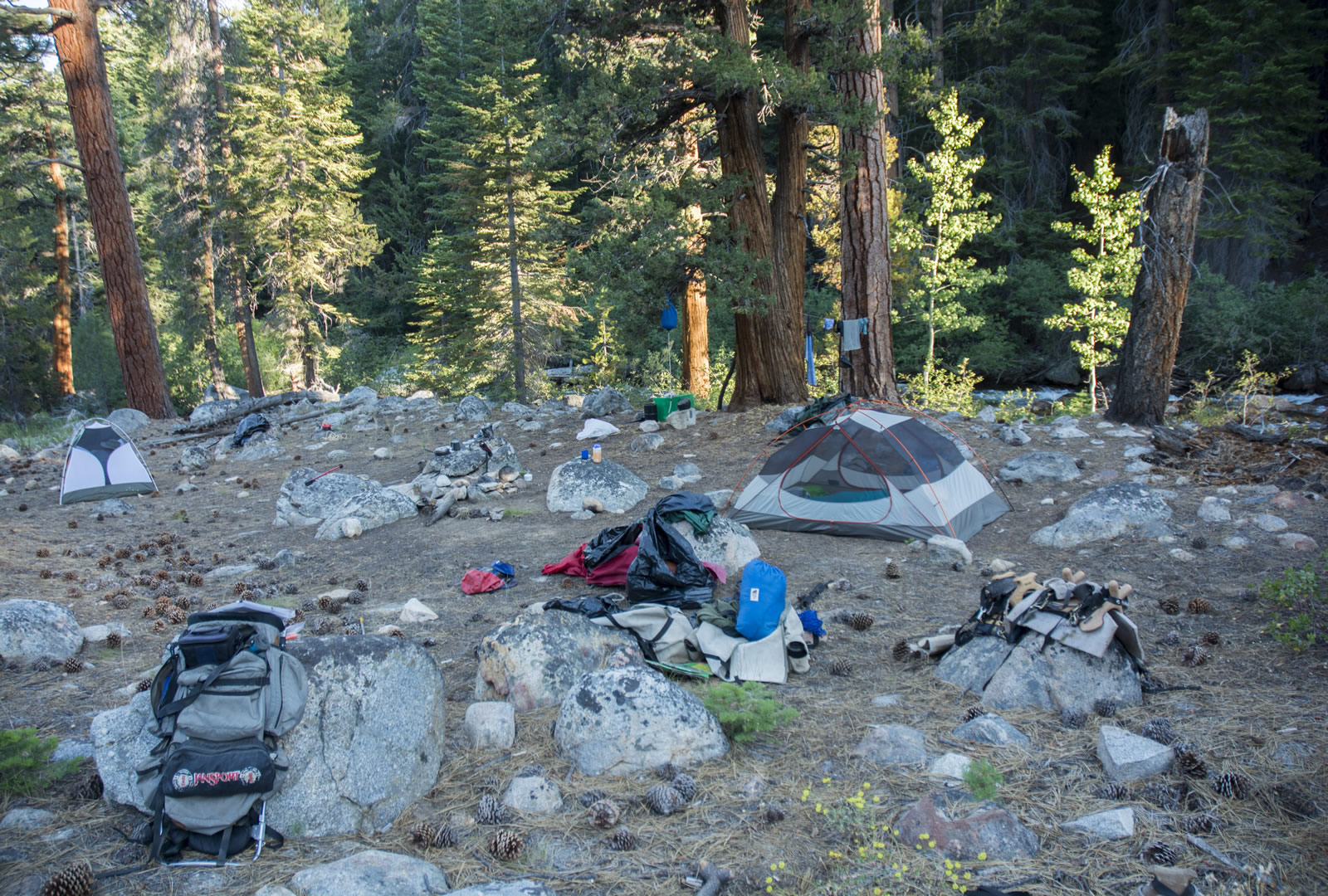
Before too long we pass the junction with Mono Creek and then soon enough are at the bridge. The trail ahead goes to Lake Edison, the Muir Trail crosses over the bridge to continue toward Selden Pass. I am wondering where Quail Meadow is, as that was my goal, but Matt says there wasn't really anything he noticed coming in. We move to the left, and while Matt and Megan check out Matt's site, I look around closer to the bridge. My area has thin grass with occasional decent grass and places where one could camp legally, but it isn't great. Megan brings back the scouting report from Matt's site: she thinks it is better, so we travel a little ways, passing a group behind a knob, and come to the site, an opening in the woods with green grass and a small spring. Matt then heads back to retrieve his pack; meanwhile Megan searches more and comes back with a better site closer to the river. While I am worried that we are closer than 100' to the water and in view where the ranger might be inclined to visit us, both Matt and Megan are more comfortable, noting others are also close to water and our site certainly is well above the water and not contributing any damage to the streamside vegetation. Another drawback only becomes clear with time: the noise from the river can make it hard to hear somebody speaking. With the llamas strung out by the spring, we set up camp (seen below the next morning).
Fires being allowed, Megan collects some wood. Meantime, Matt shares the goodies he brought for us. A pack of apple juice boxes is greeted by Megan with happiness, as is a small bag of sugar and brown sugar. I am relieved to get a spoon (mine was gone before we headed in, actually), but the choice part of the haul are 2 apples, 2 green peppers and a rather large onion. Although my veggies are still in decent shape, this is good to have as I am concerned the veggies in the resupply may be bad. Matt, meantime, is uncertain he will continue with us: his shoes' soles are separating from the uppers, and he left better shoes in his car before he got on the shuttle to Vermilion Valley Resort. So he sits near his tent trying to glue his shoes together. His journey will depend on how the glue sets overnight.
While we set up camp, the nearby group sees the llamas and is interested. They have a dog, and so I ask that the dog (which is unleashed) be kept away from the llamas (they stop eating when they spot the dog). A woman from the camp comes over and wonders if she can give the llamas some lettuce; I am not sure and so say best not to (Greg later tells me anything you can eat from the kitchen should be fine, so the llamas missed out). Megan heads over to the stream to wash up or sit in the water (I am not sure). Matt is unsure of our gravity filter and so pumps some water for himself. After awhile it is time for a meal. I move the llamas a little before dinner, which for me at least is my field burritos with the new ingredients. As we are eating we see Nick with his flag pass by across the creek, heading down towards Lake Edison.
Megan wants a fire as soon as possible, so even though it is still light and the air pretty warm, we start the fire up. She soon tires of it and heads to bed; in the end I am the one sitting by the fire who has to put the fire out as the smoke drifts over my sleeping site. I was hoping to sleep out as the mosquitoes are not too bad, but I see a bunch of ants and decide I am better off with the tent. So in the darkness (having, as usual, cleaned things in the dark) I set up my tent and hop in.
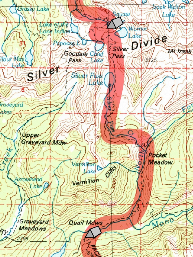
Day 7. 1.8 miles to Silver Pass, 6.5 miles to camp near Quail Meadows; 10,290' Nüümü Hu Hupi, 10,920' Silver Pass, 7900' Quail Meadows
8.3 miles, 2390' net elevation loss, 630' total elevation gain
Total to this point: 58.6 miles traveled, 10,720' total elevation gain.
prep | 0 | 1 | 2 | 3 | 4 | 5 | 6 | 7 | 8 | 9 |10 | 11 | 12 | 13 | 14 | 15 | 16 | 17 | 18 | 19 | 20 | 21 | 22 | coda | CHJ home